Up until a few months ago I was getting very reliable TFR's showing up on my G3X/45R combination. I have not checked it recently as not needed but will soon. Foreflight will capture reoccurring FTR's in the future through Wi-Fi or Cell coverage even with both of these off when checked. Foreflight seems to keep TFR's even after a re-boot so as others have said care needs to be obtained to see if Foreflight is really obtaining new TFR data or just remembering it from before.I can say that, in over four years flying with dual G3X, that I have NEVER had a TFR show up on the panel.
It would be a nice add, almost a "must-have" expectation, but I have never had it on the panel and have always referred to ForeFlight on my iPad.

Van's Air Force
You are using an out of date browser. It may not display this or other websites correctly.
You should upgrade or use an alternative browser.
You should upgrade or use an alternative browser.
G3X and TFR’s not showing
- Thread starter torquen
- Start date

I think there's a chance that we're addressing this suddenly because FIS-B has become unreliable. I can't prove it, but it's something I and others have noticed. It's really unfortunate that the FAA is deciding to cut funding for FSS with the justification that there are digital solutions, while also seemingly neglecting their digital infrastructure. I don't know if this is the definitive reason G3X systems aren't showing data (I don't have a G3X), but my iPad with foreflight and FIS-B through Sentry has been really bad the last several months. Presumably they both get the same data, and the data source is the problem.
That's wonderful! I'm sincerely happy for you, sir. You are free and clear of the anomaly and we wish you the best.Are they? I have a dual touch, 45r, and 750xi. And I'm seeing all the tfrs...
Nevertheless, there appears to be missing from your reasoning the fact that nobody with Dynon Sky View, AF5500 or AF6500 systems, or even Avidyne Vantage displays are reporting what we have experienced. The absence of TFR's on the Garmin displays is unique to the brand and needs to be addressed as such. If the FIS-B data is suspected as the source of the problem, why are the Garmin panels the only ones being affected? If other brands experience the anomaly, that would narrow our troubleshooting into a laser focus. As it now stands, we're still shooting shotguns in the dark and hoping to make apple pie out of whatever falls off the branches.
Some where it appears that people think I'm saying there isn't a problem. Couldn't be further from the truth. Also above you'll see where others have had a problem with other devices besides Garmin, albeit some components are Garmin. All I'm simply saying is I'm still waiting for someone to say, this garmin transponder, this Garmin display and this Garmin handheld device. And I've verified that none, or some are working others aren't. I see lots of I need to go checks and that's perfectly fine. I'm in the same boat. I did say, I don't know if I actually have the problem or not, I need to turn off the 51r and confirm as tfrs come over sxm as well. Having worked for SpaceX designing starlink, as it relates to determining a problem, I'm just more into RCA and taking the variables out of the equation as much as possible, e.g. distilling it down to the most common elements.That's wonderful! I'm sincerely happy for you, sir. You are free and clear of the anomaly and we wish you the best.
Nevertheless, there appears to be missing from your reasoning the fact that nobody with Dynon Sky View, AF5500 or AF6500 systems, or even Avidyne Vantage displays are reporting what we have experienced. The absence of TFR's on the Garmin displays is unique to the brand and needs to be addressed as such. If the FIS-B data is suspected as the source of the problem, why are the Garmin panels the only ones being affected? If other brands experience the anomaly, that would narrow our troubleshooting into a laser focus. As it now stands, we're still shooting shotguns in the dark and hoping to make apple pie out of whatever falls off the branches.
Never reported to Garmin as I did not know that it was supposed to be there.. . . not only "must have," but an advertised expectation. Have you ever reported this to Garmin in the 4 years you reference?
My belief was that the database is updated every 28 days and TFRs can appear instantly at any time. Therefore I have always referred to ForeFlight that is constantly updated on the internet for TFRs.
The GDL-52R does bring in weather so I suppose it makes sense to expect that it can bring in TFRs, as well.
As there are multiple mixes of equipment that allow/display ADSB information on Garmin GDUs and apps, please utilize [email protected] to provide details so the support team can compile tickets for our engineering team. Helpful information can include:
- Display(s)
- ADSB receiver (GTX/GDL)
- Communication interface (Serial, Bluetooth)
- Software levels
This will allow us to detail trends/issues on software levels in the Garmin ecosystem as well as its relation to any changes and amendments in the uplink from the FAA's FIS-B information.
- Display(s)
- ADSB receiver (GTX/GDL)
- Communication interface (Serial, Bluetooth)
- Software levels
This will allow us to detail trends/issues on software levels in the Garmin ecosystem as well as its relation to any changes and amendments in the uplink from the FAA's FIS-B information.
walkman
Well Known Member
Be careful relying on foreflight also.Yes, all TFRs will not show up through the ADS-B link. Garmin told me last year that this was a function of the data coming in from said link and was not a limitation of the Garmin unit. That being said, Foreflight displays those missing TFRs through the same data link. Hopefully someone will get a more technical answer from Garmin.
I busted a VIP TFR last summer because Foreflight didn't show the TFR. Yes, I'll put my hand up and admit that.
Neither foreflight nor my GRT system displayed it. I restarted foreflight (I think it updated) and it showed up. Luckily for me, I screen shotted the display without the TFR showing. Resulted in a couple of phone calls with the secret service and a NASA report.
Someone asked if other ADSB data came up and seems it does when I go to the Wx tab. I am getting TFR's (I think the data is not held in memory) but only if I go to the TFR tab. I am pretty sure I received TFR's before on the MAP page just like weather and traffic but nothing today. (Only if I went to the TFR tab)


If you see TFR data on the Weather page but not the Map page, take a look at your Map page settings.I am getting TFR's (I think the data is not held in memory) but only if I go to the TFR tab. I am pretty sure I received TFR's before on the MAP page just like weather and traffic but nothing today. (Only if I went to the TFR tab)
Will check the MAP page settings, thanks !If you see TFR data on the Weather page but not the Map page, take a look at your Map page settings.
==A little more data for everyone==
My configuration and connections:
GDU 465 and GDU 460 (G3X Touch)
GTN 650Xi
GTX 345
---
GDU to GTX; RS-232 & Bluetooth
GDU to GTN; ARINC. MapMX & Connext, RS-232
GTN to GTX; HSDB
The behavior:
I flew today in the central texas area between 900 and 3100 feet within 20 miles of the FAA - ADSB-X/TIS-B/FIS-B tower located at 30°35'13.75"N, 97°40'55.60"W.
The GTX 345 (via the GTN 650Xi) showed the ADSB data set was being received, 30/30 messages, NOTAM/TFR included in the data (you can see this information if you dig around in the menu items on the GTN 650xi, weather page, traffic pages).
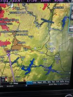
The established TFR over the SpaceX facility in MacGregor, TX *was* displayed on the Weather Page on the GTN Xi in "Yellow" not "Red." This same TFR, and all the rest nationwide, were NOT displayed on the G3X-GDU 460.
Current METARs were displayed on the GDU 460
Guess and next steps:
No change to configuration in years and this used to work.
Since the GTX 345 is receiving ADSB data and the GTN 650xi is displaying things like TFRs and the GDU is NOT, I suspect that there is a parsing/processing issue unique to the G3X stack.
Email sent to G3Xpert.
My configuration and connections:
GDU 465 and GDU 460 (G3X Touch)
GTN 650Xi
GTX 345
---
GDU to GTX; RS-232 & Bluetooth
GDU to GTN; ARINC. MapMX & Connext, RS-232
GTN to GTX; HSDB
The behavior:
I flew today in the central texas area between 900 and 3100 feet within 20 miles of the FAA - ADSB-X/TIS-B/FIS-B tower located at 30°35'13.75"N, 97°40'55.60"W.
The GTX 345 (via the GTN 650Xi) showed the ADSB data set was being received, 30/30 messages, NOTAM/TFR included in the data (you can see this information if you dig around in the menu items on the GTN 650xi, weather page, traffic pages).
The established TFR over the SpaceX facility in MacGregor, TX *was* displayed on the Weather Page on the GTN Xi in "Yellow" not "Red." This same TFR, and all the rest nationwide, were NOT displayed on the G3X-GDU 460.
Current METARs were displayed on the GDU 460
Guess and next steps:
No change to configuration in years and this used to work.
Since the GTX 345 is receiving ADSB data and the GTN 650xi is displaying things like TFRs and the GDU is NOT, I suspect that there is a parsing/processing issue unique to the G3X stack.
Email sent to G3Xpert.
Brian,This same TFR, and all the rest nationwide, were NOT displayed on the G3X-GDU 460.
RTCA/DO-358 defines Look Ahead Range as the radius for which a given product is provided from a given ADS-B ground station. The FIS-B radio stations use the look ahead range to geographically filter the set of NOTAMs that will be included in their FIS-B uplink.
FIS-B TFRs uplinked to your aircraft from nearby ADS-B ground stations have a 100 nm look ahead range, so you will never see "nationwide" TFRs when ADS-B ground stations are the source of this data.
Steve
Good to know! I didn't realize that there was a client/server relationship in FIS-B -- I thought it was just broadcast (the -B) all the time and not per-client...Brian,
RTCA/DO-358 defines Look Ahead Range as the radius for which a given product is provided from a given ADS-B ground station. The FIS-B radio stations use the look ahead range to geographically filter the set of NOTAMs that will be included in their FIS-B uplink.
FIS-B TFRs uplinked to your aircraft from nearby ADS-B ground stations have a 100 nm look ahead range, so you will never see "nationwide" TFRs when ADS-B ground stations are the source of this data.
Steve
Brian,Good to know! I didn't realize that there was a client/server relationship in FIS-B -- I thought it was just broadcast (the -B) all the time and not per-client...
That wasn't really what I communicated. The FIS-B broadcast for a particular ADS-B ground station is geographically filtered (using look ahead range), which has nothing to do with the specific aircraft in that area receiving the uplink.
Only ground stations within 100 nm of a published TFR will transmit that TFR to those aircraft listening.
Said another way, each ADS-B ground station knows it own position, and the position of all the TFRs in the U.S. It will only transmit TFRs within 100 nm of its fixed location.
Steve
Last edited:
I wouldn’t call it a client-server thing. The ground station just doesn’t send out some data that is 100 miles or more away from the ground station (not measured from your plane).Good to know! I didn't realize that there was a client/server relationship in FIS-B -- I thought it was just broadcast (the -B) all the time and not per-client...
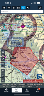
Went flying today. There is an active TFR to our East. I was going to the airport just North of it. I went to the weather page and selected TFR. Nothing on that page. I made sure TFR was selected in the airspace page. Nothing ever shows up on the G3x using a GDL50R using rs232.
Foreflight showed the TFR.
Foreflight showed the TFR.
Attachments
Hi everyone, thanks for your patience as we’ve worked to investigate the reports mentioned in this thread, and other similar reports.
Among the numerous reports of varying behavior relating to the display of TFR information, some can be attributed to variability among different data streams, and others to a problem the team has identified in our equipment.
There are a few aspects of the FIS-B data stream that can account for discrepancies in the display of TFR data across different devices. For example, ADS-B ground stations only transmit TFR data via FIS-B for local TFR’s – ‘local’ here means a look-ahead range of 100NM (see Advisory Circular 00-63B, Figure A-3). Additionally, only NOTAM-D and NOTAM-FDC products broadcast that were issued or effective within the last 30 days are made available via ADS-B (AIM Table 4-5-3). These are a result of the function of the ADS-B system, rather than an avionics or device specific function. In contrast, an EFB drawing on internet data (or stored internet data) or SiriusXM data would likely provide the data described by either of these cases, potentially leading to conflicting information between different devices.
In addition to these inherent sources of variability, our team has been able to identify a graphical TFR issue in our display products which leads to lost data in certain circumstances. The following products are affected:
As always, please feel free to reach out to [email protected] to get connected with our team.
Among the numerous reports of varying behavior relating to the display of TFR information, some can be attributed to variability among different data streams, and others to a problem the team has identified in our equipment.
There are a few aspects of the FIS-B data stream that can account for discrepancies in the display of TFR data across different devices. For example, ADS-B ground stations only transmit TFR data via FIS-B for local TFR’s – ‘local’ here means a look-ahead range of 100NM (see Advisory Circular 00-63B, Figure A-3). Additionally, only NOTAM-D and NOTAM-FDC products broadcast that were issued or effective within the last 30 days are made available via ADS-B (AIM Table 4-5-3). These are a result of the function of the ADS-B system, rather than an avionics or device specific function. In contrast, an EFB drawing on internet data (or stored internet data) or SiriusXM data would likely provide the data described by either of these cases, potentially leading to conflicting information between different devices.
In addition to these inherent sources of variability, our team has been able to identify a graphical TFR issue in our display products which leads to lost data in certain circumstances. The following products are affected:
- G3X Touch displays running v9.52, receiving FIS-B data from:
- GDL 5X(R) v2.23
- GDL 39(R) v4.91 (only Bluetooth connection affected)
- GNX 375 v3.22
- GTX X45(R)(D) v2.90
- Aera 660 and 760 running v4.21, receiving FIS-B data from:
- GDL 5X(R) v2.23 (only RS-232 connection affected)
As always, please feel free to reach out to [email protected] to get connected with our team.
This makes me smile and a little chuckle too. I have two G3X, GDL52, GNX375, and AERA 760 all mentioned above and in one cockpit and I am based thru the summers only 3 miles from the Wash/DC "temporary" TFR's. Also after last 4 years of "POP-UP TFR's" in Delaware, Maryland and New Jersey, I look forward to and welcome this software improvement. I can possibly leave the I-PAD with Garmin Pilot at home!
Heya Garmin, I have a suggestion. The rendering of TFR's on the map is really subtle and easy to miss. Foreflight choses an semi-transparent red shading layer that is impossible to miss. Any thoughts of changing the depiction on the G3X?
Regards,
G
Regards,
G
Any word on when we can expect an update? We're into November and not a peep...Hi everyone, thanks for your patience as we’ve worked to investigate the reports mentioned in this thread, and other similar reports.
Among the numerous reports of varying behavior relating to the display of TFR information, some can be attributed to variability among different data streams, and others to a problem the team has identified in our equipment.
There are a few aspects of the FIS-B data stream that can account for discrepancies in the display of TFR data across different devices. For example, ADS-B ground stations only transmit TFR data via FIS-B for local TFR’s – ‘local’ here means a look-ahead range of 100NM (see Advisory Circular 00-63B, Figure A-3). Additionally, only NOTAM-D and NOTAM-FDC products broadcast that were issued or effective within the last 30 days are made available via ADS-B (AIM Table 4-5-3). These are a result of the function of the ADS-B system, rather than an avionics or device specific function. In contrast, an EFB drawing on internet data (or stored internet data) or SiriusXM data would likely provide the data described by either of these cases, potentially leading to conflicting information between different devices.
In addition to these inherent sources of variability, our team has been able to identify a graphical TFR issue in our display products which leads to lost data in certain circumstances. The following products are affected:
These issues will be corrected in forthcoming software updates. We will update the group here when these are available for download.
- G3X Touch displays running v9.52, receiving FIS-B data from:
- GDL 5X(R) v2.23
- GDL 39(R) v4.91 (only Bluetooth connection affected)
- GNX 375 v3.22
- GTX X45(R)(D) v2.90
- Aera 660 and 760 running v4.21, receiving FIS-B data from:
- GDL 5X(R) v2.23 (only RS-232 connection affected)
As always, please feel free to reach out to [email protected] to get connected with our team.
rcarsey
Well Known Member
I may as well add to the thread as well. I have the G3x v9.52 and GDL52R v2.23 (FIS-B only, no XM). The G3x did not display a TFR in the Jacksonville, FL (JAX) area. Whether the FAA was not transmitting it, or the GDL/G3x wasn't interpreting it -- I don't know. It was displaying other TFRs (e.g. Disney World) and there were 2 UAT ground stations nearby (just north and south of JAX).
I was aware of the TFR just through pre-flight planning. Garmin Pilot (ios) (with an active wi-fi connection in flight too) was displaying it.. However, it was showing a multi-area TFR (all with different altitudes) with the same altitude. I decided that I must have made a mistake during pre-flight (or maybe the TFR had changed since pre-flight) -- and I flew right through it. One of my buddies that was following me on the ground sent me a text message asking me why I was going through a TFR.. We had an argument (as I was looking at live data in Garmin Pilot). It seems Garmin Pilot displays a multi-area TFR with each area's altitude with the 1st area's altitude. He was looking at SkyVector.
In the screenshot, I was at 2600', overflying a Class D and a TFR.. or so I thought. But that area was actually 2500-8500'
Attachments
File an ASRS report...I may as well add to the thread as well. I have the G3x v9.52 and GDL52R v2.23 (FIS-B only, no XM). The G3x did not display a TFR in the Jacksonville, FL (JAX) area. Whether the FAA was not transmitting it, or the GDL/G3x wasn't interpreting it -- I don't know. It was displaying other TFRs (e.g. Disney World) and there were 2 UAT ground stations nearby (just north and south of JAX).
I was aware of the TFR just through pre-flight planning. Garmin Pilot (ios) (with an active wi-fi connection in flight too) was displaying it.. However, it was showing a multi-area TFR (all with different altitudes) with the same altitude. I decided that I must have made a mistake during pre-flight (or maybe the TFR had changed since pre-flight) -- and I flew right through it. One of my buddies that was following me on the ground sent me a text message asking me why I was going through a TFR.. We had an argument (as I was looking at live data in Garmin Pilot). It seems Garmin Pilot displays a multi-area TFR with each area's altitude with the 1st area's altitude. He was looking at SkyVector.
In the screenshot, I was at 2600', overflying a Class D and a TFR.. or so I thought. But that area was actually 2500-8500'
I've got a G3X and GDL39 and sometimes I'll see then TFRs show up, other times not. As far as I can recall it's always been that way with this hardware combination in my aircraft.
Whether you're using a G3X, ForeFlight, Garmin Pilot, or other charting solution, I'd encourage people to be extremely careful these days about TFRs. Electronic solutions can be dicey. Sometimes they don't have the data. Other times they remove it at certain zoom levels, or only refresh every so often.
As a result, I always check the tfr.faa.gov web site. I see the TFR situation as a minefield every bit as bad as the NOTAM mess. There are graphically published TFRs, implied but unpublished TFRs (aka stadiums), and a plethora of drone TFRs now showing up in my neighborhood. A couple of weeks ago I counted 14 of them in the SoCal area alone. I called AOPA to see if they could shed any light on what was happening, but all I could get was a verbal shoulder shrug.
--Ron
rcarsey
Well Known Member
Even the official site isn't quite official..I've got a G3X and GDL39 and sometimes I'll see then TFRs show up, other times not. As far as I can recall it's always been that way with this hardware combination in my aircraft.
Whether you're using a G3X, ForeFlight, Garmin Pilot, or other charting solution, I'd encourage people to be extremely careful these days about TFRs. Electronic solutions can be dicey. Sometimes they don't have the data. Other times they remove it at certain zoom levels, or only refresh every so often.
As a result, I always check the tfr.faa.gov web site. I see the TFR situation as a minefield every bit as bad as the NOTAM mess. There are graphically published TFRs, implied but unpublished TFRs (aka stadiums), and a plethora of drone TFRs now showing up in my neighborhood. A couple of weeks ago I counted 14 of them in the SoCal area alone. I called AOPA to see if they could shed any light on what was happening, but all I could get was a verbal shoulder shrug.
--Ron

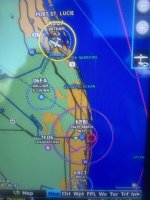
And now this week's TFR at the CRG vortac is showing SFC-14000 for all areas - which is the most minimum and most maximum of all areas listed in the TFR.
.png")
Last edited:
Issue was long before 9.52. I’ve hade my system for over 4 years and it’s never showed the TFR’s not just my system but others I know as well. Pretty crazy how this just slipped through the cracks for years.@g3xpert
Sooooooo --- Issue introduced in the 9.52 update in March, root cause and fix(es) identified in mid-September... (pause for dramatic effect)...
I'd like to be able to avoid any/all Santa Klaus related TFR's, what are the odds we'll get a patch before the end of the year?
With the recent helicopter crash where it hit a “slack line”, it would be really nice if the g3x system showed notams as well. On Foreflight the notams will show up enroute as a grey circle that allow you to click and gather the info.
Still no update available from Garmin on the TFR issues. 9.52 was released back in March and is still the current version.
Still no update available from Garmin on the TFR issues. 9.52 was released back in March and is still the current version.
Still no update available from Garmin on the TFR issues. 9.52 was released back in March and is still the current version.
We're now looking at one year since the last software update. The wait on getting this issue resolved appears to be much longer than anticipated. It must be a real humdinger of a problem.These issues will be corrected in forthcoming software updates. We will update the group here when these are available for download.
g3xpert, what's the latest update you can give us? Are we Garmin users going to be eternally bound to carry iPads or other devices with us to ensure TFRs are not being violated? What kind of progress is being made to get this fixed?
Thanks in advance for keeping us in the loop.
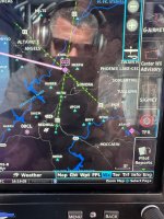
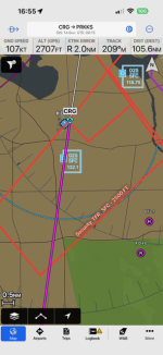
Flying Saturday I had a TFR box on the map page of my G3X for the first time. See the northeast edge (2 o’clock) of the glide distance ring.What kind of progress is being made to get this fixed?

I contacted Garmin g3x via email a few days ago. I explained that it’s been a year since the last update and TFR’s don’t pop up.
They wrote back saying they understand my frustration and the engineers are aware and working on it. And they would add me to the ticket so when an update comes they will email.
Maybe they don’t think this is much of an issue? I suggest that everyone here send an email expressing your concern and make sure they get on it.
As much as I like my G3x system, I am definitely thinking of going a different way on my next plane after the countless slow issues I’ve had due to firmware updates.
Different story than what we were told in September 2025 -- "We've fixed the issue -- will be updated in a forthcoming release."I contacted Garmin g3x via email a few days ago. I explained that it’s been a year since the last update and TFR’s don’t pop up.
They wrote back saying they understand my frustration and the engineers are aware and working on it. And they would add me to the ticket so when an update comes they will email.
Maybe they don’t think this is much of an issue? I suggest that everyone here send an email expressing your concern and make sure they get on it.
As much as I like my G3x system, I am definitely thinking of going a different way on my next plane after the countless slow issues I’ve had due to firmware updates.
Greetings VAF community,
We apologize that this fix has been slow in coming. We have the problem identified and addressed. At this point, we are working to ensure that we have enough testing on these and the other features we have been hard at work to bring you! While many of you are experiencing this on a regular basis, we have to ensure that our testing is representative of all environments. As usual, we are working to balance the inevitable complications and priorities.
While we do not have a specific release date to offer, we will keep you posted as things progress. Thank you again for your continued patience.
Thanks,
Justin
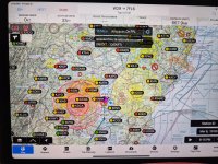
While the fix is not available to the G3X yet, I began learning to use the Garmin Pilot APP on my IPAD a whole lot more and discovered what I think may be a new feature. "Graphic Notams" when I activated this feature it opened up a new wealth of information. Active SUA's, 24hour notice's of intended TFR's, as well as active TFR's. active warning area's (probably live fire training areas). to even include active Parachute area's. My MAP page just got a lot more crowded but with really helpful information. I'm not sure where the source is for this information as I have Cell Service, WIFI, and Sirius XM Aviation all on the same IPAD while on the ground. I have not tried the feature Graphic Notams in flight yet.
Attachments
Last edited:
