A *unique* iphone/ipad app indeed ...
Wednesday I had the opportunity to ride along with the developer of the Xavion app and get a first hand demonstration. It was extremely impressive! I would say this is probably the least expensive "insurance" for an airplane of any make or model ($99.99 and no, I'm not on the payroll!). Some of you may be familiar with what this does as it is the software that runs the VP-400 that leads the airplane down to a safe landing on an airport if at all possible. It constantly computes the path, both laterally and vertically, to an airport and provides boxes (highway in the sky) on the synthetic vision display as well as lots of other neat and valuable information. I came home and looked at the website on it, and let me say that seeing it is much more impressive! It runs on iPad 2 or later, iPad mini, and iPhone 4 and later I believe.
Anyway, I just wanted to put out the word in case anyone already flying wants to try a really cool app that is actually a big safety item. And if you want some more info., maybe James Clark will chime in, as he and my husband, Ken, were on the demo. flight as well (yes, Ken has already downloaded it! & James too!!).
I was going to wait until I had a chance to "fly it" myself, but here goes ..
Disclaimer: I have known Austin Meyer (developer of X-Plane and developer of XAVION) for some number of years as we used to have hangars not far apart here in Columbia.
So .....
I come across info about the iPad app that does a lot of the VP-400 like stuff and being a bit behind about all of its feature, I decide to shoot an email to Austin about it, letting him know I was purchasing a copy and to ask questions and give comments. Instead of just replying to my email he says .."hey, I can give you and a couple of friends a DEMO of it all in my Columbia 400. Wanna do it? .."
**ABOSOPOSITIVELY**!
So we all meet at the airport and he gives us the debrief on the ground about its features. Won't try to cover all that here and instead more about the flight.
Off we go, heading toward an airport a bit away from the Columbia airspace.
The first thing that I notice is that the visuals make it clear that in THAT airplane with the data that IT had compiled over time, that we could NOT make a turn back to the airport and safely make it for some time. Hmmm.... did I really want to know that?? Well, actually yes. Even though I thought we could not, it showed clearly where we reasonably could get to and not get to.
As we climbed, it further opened up the map part of the display, showing where we could glide to if there was an engine out. Interesting.
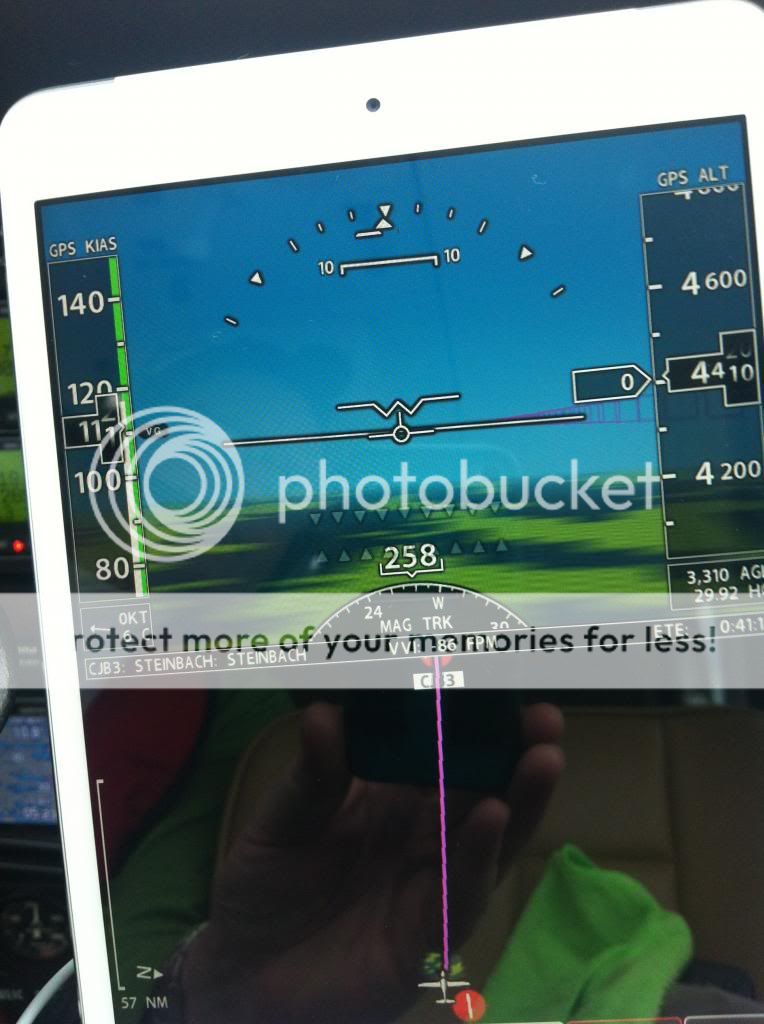
Next, as we got a little higher and started turning, it constantly computed a "path" back to KCAE if the engine quit AND constantly updated it. What I mean here is that it would in real time change which runway was the best choice based on our altitude and position. It also showed the turns that would be needed in order to not overshoot. This is COOL! And we are still talking to the tower!!
Then another interesting thing occurred. It went from showing me airports that we could make (KCAE and KCUB) to NONE! Yikes!!! Yes I knew this but it put it right there in my face!
")
Austin casually says, yep this lets me know that I should go for a road or field and not try to make the airport and end up hitting buildings!
Alright this app is working hard, but there are apps like AnyWhereMap that has cones of safety to kinda show you where you can glide to. What is different here is that this app has an irregular MAP that it builds in real time. And the map gets bigger as we get higher but is odd shaped as you probably can go further ahead than behind, assuming no wind.
So, we finally get to our real "DEMO" area. Austin slowly throttles back (Turbocharged BIG ENGINE up front) and says, " ... assume we are in the clouds at night and you have NO engine power ... this will help you get safely to the ground...". He presses the EMERGENCY button on the iPad and a highway in the sky is built with a SPECIFIC path to the nearest/most appropriate runway at the nearest/most appropriate airport. With three other pilots in the plane (including one who has a bazillion hours flying Delta Jets Internationally <Melinda>), some of us are looking outside for traffic, some of us are looking at the app on iphone, ipad mini and ipad as he looks EXCLUSIVELY at the highway in the sky and follows the hoops with its outbound turns and circles etc and glides us right down the chute to a perfect setup for landing. NICE!
There are a lot of other features but this is what the app was primarily built to do. An extra bit of "get out jail" when things go wrong.
Austin pointed out (both on website and to us verbally) that this is NOT an app to replace your ForeFlight or WingX or Garmin Pilot or AnyWhereMap etc.
He also has not replaced his EFIS
(dual G1000, I think in this plane). It is a COMPLEMENT to how you fly today.
And even if you have NONE of the fancy stuff in your plane today, this would be a nice addition as the "highway in the sky (HITS)" can be used to provide guidance from airport A to airport B. Not the main focus but it is there.
So, yes, we were pretty impressed with what is a unique app for the iPhone and iPad.
It is not free and it cost more that a dollar, but if it is called upon ONCE, it will pay for itself 100x.
James