

PilotjohnS
Well Known Member
I did a night cross country from LA to Vegas this week. My take off was from the LA area in the daytime, with landing in Vegas at sunset. My intent was to land at North Las Vegas airport. However, since I was coming from the southwest, the controller couldn't get me across the McCarran traffic pattern right away. So I was forced to hold over Henderson. This was a VFR trip, but the Class B around Vegas kind of blocks VFR self navigating. The controllers were very good about giving permission to operate in class b airspace if I followed their instructions.
After a lap, I gave up on North Las Vegas and landed at Henderson just at sunset. Needless to say the airport was deserted except for the two women at the terminal counter. A quick Uber, a few dollars left behind and hour later I arrived back at Henderson for the return flight. This was going to be a challenging night cross country VFR. There were no clouds, little wind, and visibility was unlimited.
If you are familiar with the Vegas area, Henderson sits on the southern end with the bright city to the north, dark desert to the south, and unlit mountain's to the west.
I decided on a box departure from runway 35 to gain altitude, with a jog to the southeast to pick up the victor airway. The thought being the victor airway would guide me through the 8000’ mountains to the south west.
Takeoff and first turn back towards the city was uneventful. But after the second turn towards the desert, it got very dark. And very disorienting; i could not see any mountains, just darkness. I couldn't tell if those were lights in the distance or stars. Did I already say this was tough VFR. So head down and I flew the flight plan as if it was an IFR flight with brief look for traffic. I tried to engage the autopilot at 800 feet agl. The autopilot did an immediate turn to the right with a terrain warning straight ahead. I think the autopilot didn't figure on the climb rate and it just saw clearance from my altitude to terrain ahead being too low. Who knew the autopilot wont let one fly into terrain.
After fighting the autopilot, I was finally high enough, and on course, for Otto to take over.
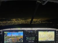
The rest of the flight was uneventful. Besides GPS, the glow of LA was enough of a sign post for guidance.
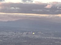
Photos are arrival at sunset. The sphere is quite visible and looks cool. I feel sorry for the neighbors.
The last picture is returning to LA with the darkness above.
Lesson learnt:1) No reason to do a box departure from Henderson since the climb rate of the RV is sufficient to miss the 8000’ mountains 20 miles down range. Better to be on autopilot than do fancy departure flying by hand.
2) Night VFR cross country should really be considered an IFR flight, planned, and flown that way
After a lap, I gave up on North Las Vegas and landed at Henderson just at sunset. Needless to say the airport was deserted except for the two women at the terminal counter. A quick Uber, a few dollars left behind and hour later I arrived back at Henderson for the return flight. This was going to be a challenging night cross country VFR. There were no clouds, little wind, and visibility was unlimited.
If you are familiar with the Vegas area, Henderson sits on the southern end with the bright city to the north, dark desert to the south, and unlit mountain's to the west.
I decided on a box departure from runway 35 to gain altitude, with a jog to the southeast to pick up the victor airway. The thought being the victor airway would guide me through the 8000’ mountains to the south west.
Takeoff and first turn back towards the city was uneventful. But after the second turn towards the desert, it got very dark. And very disorienting; i could not see any mountains, just darkness. I couldn't tell if those were lights in the distance or stars. Did I already say this was tough VFR. So head down and I flew the flight plan as if it was an IFR flight with brief look for traffic. I tried to engage the autopilot at 800 feet agl. The autopilot did an immediate turn to the right with a terrain warning straight ahead. I think the autopilot didn't figure on the climb rate and it just saw clearance from my altitude to terrain ahead being too low. Who knew the autopilot wont let one fly into terrain.
After fighting the autopilot, I was finally high enough, and on course, for Otto to take over.
The rest of the flight was uneventful. Besides GPS, the glow of LA was enough of a sign post for guidance.
Photos are arrival at sunset. The sphere is quite visible and looks cool. I feel sorry for the neighbors.
The last picture is returning to LA with the darkness above.
Lesson learnt:1) No reason to do a box departure from Henderson since the climb rate of the RV is sufficient to miss the 8000’ mountains 20 miles down range. Better to be on autopilot than do fancy departure flying by hand.
2) Night VFR cross country should really be considered an IFR flight, planned, and flown that way
Attachments
Last edited:

