

RV-14E
Well Known Member
Greetings.
Version 5.7 of my flight data analysis program has been released (original posts 15-Sep-19 and 2-May-20). It's been more than a year since there's been an update.
It's a public domain VBA, Excel-based program to view and analyze the following EFIS file types:
I don't check my DMs typically. You can find my contact information on the spreadsheet.
----------
Click any image below to see a larger version. You can see more screenshots, videos and learn more about it here: https://rv-14a.blogspot.com/2020/05/avionics-new-grt-flight-data-analysis.html. GRT offers a link to the software their website too: https://grtavionics.com/miscellaneous-software/
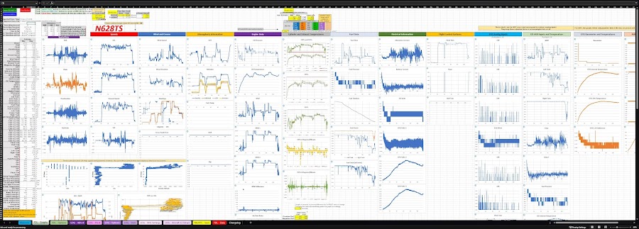
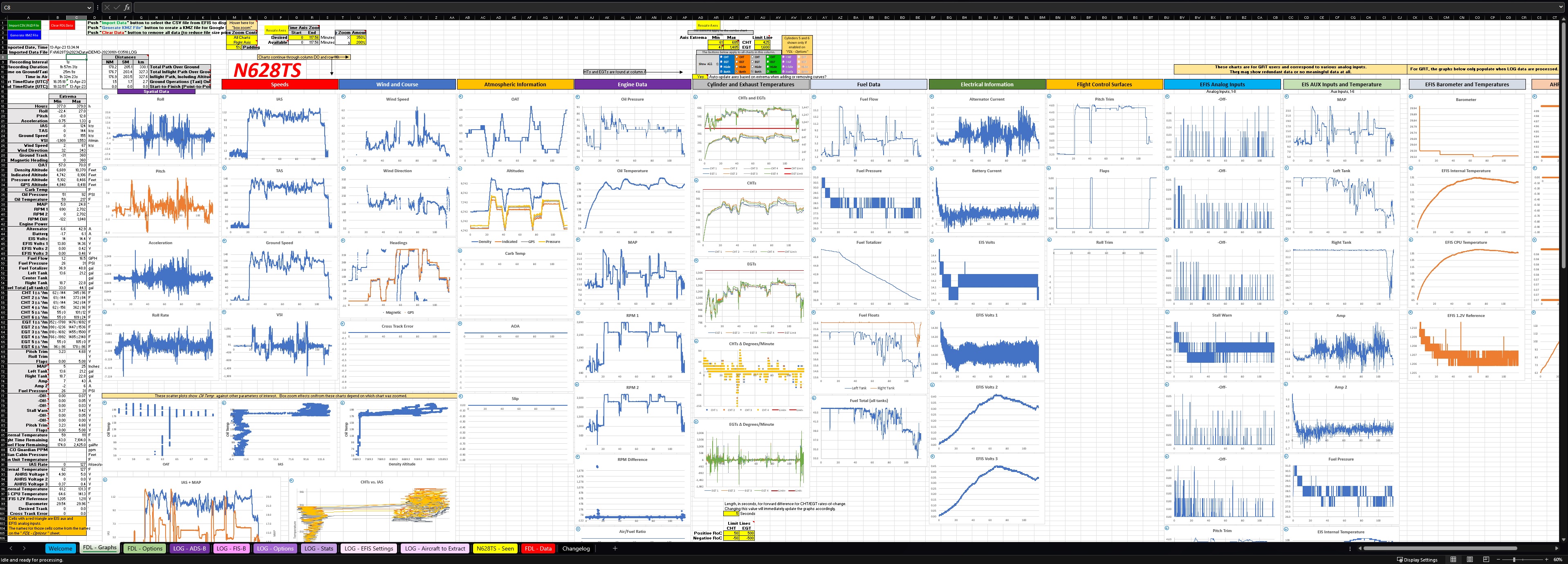
Here is an example of the comprehensive data you can view with this program. It's basically every graphable parameter in a GRT/Garmin/Dynon/AFS EFIS' CSV file and GRT's LOG file. You can zoom in on any single graph or all graphs with a click-and-zoom function with multi-level unzoom.
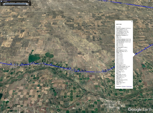
It also creates animated KML files for viewing your flight (and for GRT LOG file users, the other aircraft around you) in 3D in Google Earth. You can view engine and flight data at any point along the way, see nearest airports and project FAA charts on the terrain. You can "fly" your flight in Google Earth with "virtual pilot" mode.
Flight data shown at specific point along the flight:
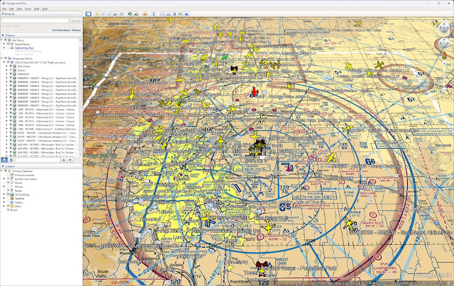
FAA charts (sections, IFR, etc.) can be projected on the terrain (below shown with ADS-B traffic, which is for GRT LOG files users only):
For GRT users, the LOG files provide a complete capture of the flight so we get insight into the entire flight, not just engine and spatial data.
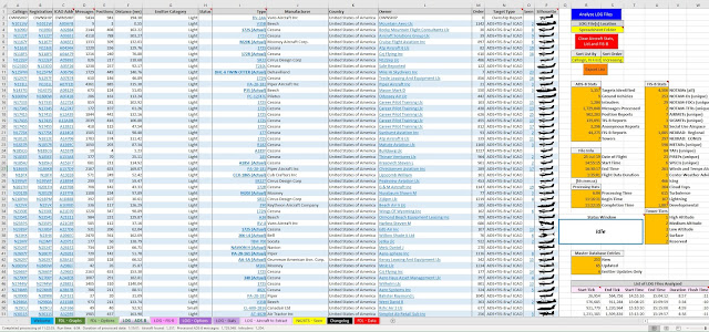
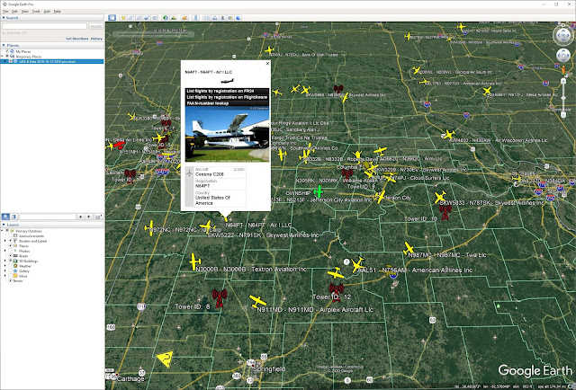
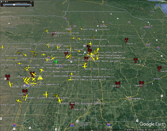
For example we get a full capture of ADS-B data so we can get a near complete picture of the aviation environment. You can get a list of all aircraft in the sky during your flight. A full list is constructed including callsign, registration, type, manufacturer, owner, etc. and can include highly accurate silhouettes of each aicraft based on its manufacturer and type.
A fully rendered KML file of all aicraft present during your flight can be created. You can click on any aircraft and get a plethora of data about it, including its past flights, owner, type, etc. and even an actual picture of that specific aircraft uniquely determined by its registration. Many aircraft are accurately represented by the more than 30 icons I include.
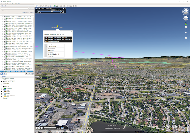
You can take the perspective of your cockpit and see the other aircraft flying around you, like this:
You can view all FIS-B weather at airports in Google Earth and get a full list of weather info in the spreadsheet.

The ADS-B ground-based transceivers (a.k.a., "towers") that provided data to you on your flight are plotted in red.
When processing GRT LOG files, a list of what devices are connected to your EFIS, what the analog inputs are defined as, what the serial port and EIS setups are and the amount of data each device transmitted to your EFIS is provided.
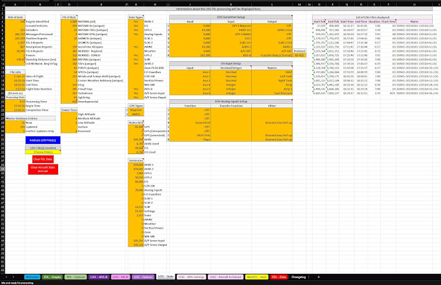
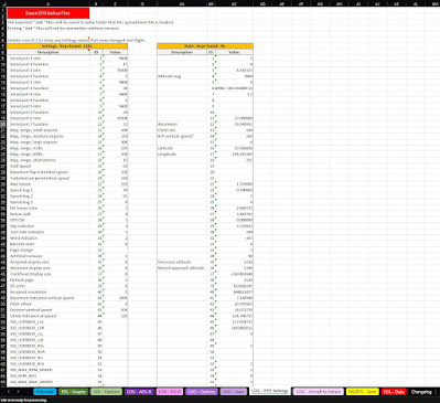
When processing GRT LOG files, all EFIS settings are captured in the LOG files and can be extracted. Settings that change mid-flight are tracked. These settings can be exported to a .bak file to later directly upload to your EFIS. Thus settings can be extracted from any LOG file, should you forget to make a backup through the EFIS menu.
Version 5.7 of my flight data analysis program has been released (original posts 15-Sep-19 and 2-May-20). It's been more than a year since there's been an update.
It's a public domain VBA, Excel-based program to view and analyze the following EFIS file types:
- GRT LOG and CSV files
- Garmin, Dynon and AFS CSV files
- Seattle Avionics FlyQ EFT XML files (kinda)
I don't check my DMs typically. You can find my contact information on the spreadsheet.
----------
Click any image below to see a larger version. You can see more screenshots, videos and learn more about it here: https://rv-14a.blogspot.com/2020/05/avionics-new-grt-flight-data-analysis.html. GRT offers a link to the software their website too: https://grtavionics.com/miscellaneous-software/
Here is an example of the comprehensive data you can view with this program. It's basically every graphable parameter in a GRT/Garmin/Dynon/AFS EFIS' CSV file and GRT's LOG file. You can zoom in on any single graph or all graphs with a click-and-zoom function with multi-level unzoom.
It also creates animated KML files for viewing your flight (and for GRT LOG file users, the other aircraft around you) in 3D in Google Earth. You can view engine and flight data at any point along the way, see nearest airports and project FAA charts on the terrain. You can "fly" your flight in Google Earth with "virtual pilot" mode.
Flight data shown at specific point along the flight:

FAA charts (sections, IFR, etc.) can be projected on the terrain (below shown with ADS-B traffic, which is for GRT LOG files users only):

For GRT users, the LOG files provide a complete capture of the flight so we get insight into the entire flight, not just engine and spatial data.
For example we get a full capture of ADS-B data so we can get a near complete picture of the aviation environment. You can get a list of all aircraft in the sky during your flight. A full list is constructed including callsign, registration, type, manufacturer, owner, etc. and can include highly accurate silhouettes of each aicraft based on its manufacturer and type.

A fully rendered KML file of all aicraft present during your flight can be created. You can click on any aircraft and get a plethora of data about it, including its past flights, owner, type, etc. and even an actual picture of that specific aircraft uniquely determined by its registration. Many aircraft are accurately represented by the more than 30 icons I include.

You can take the perspective of your cockpit and see the other aircraft flying around you, like this:

You can view all FIS-B weather at airports in Google Earth and get a full list of weather info in the spreadsheet.

The ADS-B ground-based transceivers (a.k.a., "towers") that provided data to you on your flight are plotted in red.

When processing GRT LOG files, a list of what devices are connected to your EFIS, what the analog inputs are defined as, what the serial port and EIS setups are and the amount of data each device transmitted to your EFIS is provided.

When processing GRT LOG files, all EFIS settings are captured in the LOG files and can be extracted. Settings that change mid-flight are tracked. These settings can be exported to a .bak file to later directly upload to your EFIS. Thus settings can be extracted from any LOG file, should you forget to make a backup through the EFIS menu.


