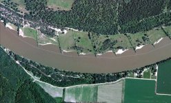
If I had to take a guess, I'd surmise that it's a protective island upstream from the embankment at the existing lock and dam.
Again, just guessing, but the likely goal of the Lock and Dam protective island would be to safeguard the existing embankment on the upstream, windward side acting as a buffer from wind and wave erosion. The 3,250-foot-long earthen embankment probably suffered degradation due to weather conditions, lack of vegetation, and the erosive effects of high-water events. The island would possibly be constructed using near-by river material from the 9-foot navigation channel that will feature various heights above the typical pool elevation to provide habitat benefits including tall grasses, tree plantings, a wetland, rock features and an overwintering fish habitat.
But that's just a guess.