

Van's Air Force

The definitive Van's Aircraft support community! Buying, building or flying an RV? Join our exclusive family of mentors and enthusiasts!

OSHKOSH microwave tower

RNB

Well Known Member
Sponsor
I have no idea what a microwave tower looks like. The Notam from last year pointed at it in the distance but nothing stood out. I've searched google map images but can't see anything.
What does a microwave tower look like?
How well does this stand out flying in?
Any specific images you can share?
How about circling it on a map so I can see it?
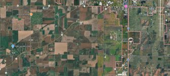
 

Attachments

  • Image 5-16-26 at 09.00.jpeg
    Image 5-16-26 at 09.00.jpeg
    875.6 KB · Views: 44
I have no idea what a microwave tower looks like. The Notam from last year pointed at it in the distance but nothing stood out. I've searched google map images but can't see anything.
What does a microwave tower look like?
How well does this stand out flying in?
Any specific images you can share?
How about circling it on a map so I can see it?
Sure - zoom to the south east intersection of Fisk & James Streets., 43.948945°N, 88.644388°W

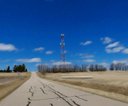
Here's the street view looking North/North East along James Street.

Screenshot 2026-05-16 at 8.11.31 AM.png

Looks like one of the old AT&T "Long Lines" Microwave Relay towers...
 
  • Like
Reactions: RNB
Just south of Fisk Ave, on James Road:


Midwesterners are used to seeing these things lurking on the horizon!

(edit: Brian beat me by a few seconds!)
 
It looks real close to Fisk? So when they say to keep that tower off to your right, they really mean keep it tight along the road.
 
It looks real close to Fisk? So when they say to keep that tower off to your right, they really mean keep it tight along the road.
That would be my inference as well...It's been so long for me, I don't recall the directions. I just remember "RV - rock your wings" and watching 15 other airplanes in front of me rocking their wings.
 
As we always tell people, if you can see the road you're over, you’re not OVER the road…. 😉

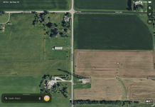
Here is the tower and its shadow, bottom center of the picture. If you are low enough for the tower to be an issue, you are WAY to low!

IMG_0625.png
 
How well does this stand out flying in?

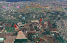
Inbound from Fisk is really obvious. Big picture is a straight road due east when the controllers say turn, with the airport clearly in view. I wouldn't waste eyeball time looking for a tower (below, blue). A little left or right isn't a problem. High/low, or off speed are issues.

BTW, do not descend along that path. The microwave tower has been used as a photo plane meeting point for the light stuff out of the Red Barn strip. If so, they should be 500 below you. The pattern at the Red Barn (orange) is 300 AGL, with an entry/exit under the Fisk inbound at Hwy 41.

ScreenHunter_3276 May. 16 09.23.jpg
 
If you ever get the opportunity to fly into the Pioneer runway at KOSH, that approach uses the microwave tower as well.

If whoever owns that tower someday decides to decommission it, EAA may have to buy it. Imagine an aviation group advocating to keep a tower up!
 
Back
Top