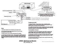
The Mini doesn't have built-in ARINC-429 so if you don't have a GRT ARINC-429 module you will need one to input the ARINC-429 data and the module wires to one of the serial inputs.
The ARINC-429 module document is on our Miscellaneous Documentation page:
https://grtavionics.com/miscellaneous-documentation/
RS-232 connection
GPS175 Pin 9 (RS-232 OUT 1) -- any serial input on EFIS
Example 1: GPS175 Pin 9 (RS-232 OUT 1) -- Mini pin 2 (Serial 1 IN)
Example 2: GPS175 Pin 9 (RS-232 OUT 1) -- GRT ARINC pin 8 (Serial Input pass-thru on male DB9 on box)
A direct connection to the display is preferred unless you're out of serial ports.
You would not connect the serial grounds.
If you are already using one of the Aviation Outputs for the King or something else, you may be able to set another output or you may need to splice into that existing wire. Some Garmins won't let you set two outputs to the same thing, so check the settings before you wire it.
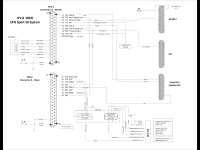
ARINC connections
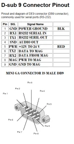
The GRT ARINC-429 connector (female DB9 on external module box or back of HX/HXr) will be referred to as the C connector here.
GPS175 Pin 5 (ARINC 429 OUT 1A) -- GRT ARINC pin C1 (ARINC 429 IN 1A)
GPS175 Pin 6 (ARINC 429 OUT 1B) -- GRT ARINC pin C2 (ARINC 429 IN 1B)
GPS175 Pin 27 (ARINC 429 IN 1A) -- GRT ARINC pin C5 (ARINC 429 OUT A) -- non-certified only
GPS175 Pin 28 (ARINC 429 IN 1B) -- GRT ARINC pin C9 (ARINC 429 OUT B) -- non-certified only
(Any other RS-232 input/output and ARINC-429 input/output can be substituted.)
GPS175 Settings:
ARINC RX Port 1: (input to 175 for non-certified only)
Format: EFIS/ADC
Speed: Low
ARINC TX Port 1:
Format: GAMA Format 1
Speed: Low
RS232 Port 1: Aviation Output 1
The 175 does not have an RS-232 Fuel/Air Data (FADC) input like other Garmin IFR GPS units.
EFIS Settings in SET MENU, General Setup:
For units with external ARINC module: ARINC Module Connected: Yes, Port (select port it's wired to)
ARINC Receive Rate: Low
ARINC Transmit Rate: Low
Serial Port Rate: 9600
Serial Port Input: GPS1 Aviation/MapCom
The Serial Port Output is not used for the 175 and can be used for unrelated functions at 9600 baud.
Using GPS1 for the GPS175 is recommended and sometimes required. Change any other GPS to GPS2 (change Internal GPS to GPS2).
If the GPS RS-232 is connected to the pass-thru port (pins 8 and 9) on the external ARINC module male DB9,
configure the serial port that the ARINC module is connected to as 9600 GPS1 Aviation/MapCom.
For example, if the ARINC module is connected to port 1 and the GPS RS232 data is connected to its pass-thru port, the settings would look like this:
ARINC Module Connected: Yes, Port 1
For software before July 2022:
Serial Port 1 Rate: 9600
Serial Port 1 Input: GPS1 Aviation/MapCom
The July 2022 and newer software will rename the pass-thru port to AMPT Serial Port:
AMPT Serial Port Rate: 9600
AMPT Serial Port Input: GPS1 Aviation/MapCom
If nothing is connected to the pass-thru port then the serial port input/output would be Off.
Other settings in General Setup:
ARINC GPS Input: GPS1
This tells the EFIS to use the GPS data from the ARINC-429 connection when GPS1 is selected.
NAV Mode Source: Internal
The GPS175 does not have a built-in VOR/ILS receiver, so all mode changes must be done in the EFIS.
GPS1 Flight Plan Source: External
This tells the EFIS to use GPS flight plan data from the GPS175 RS-232 connection.
GPS2 Flight Plan Source: update this to match your GPS2, if any.
GRT GPS units should be Internal. GPS units that transfer flight plan data should be External.
Virtual GPS2: Normally Off unless you know you want this feature.
If you have two GPS inputs this must be Off.
Settings in SET MENU, Primary Flight Display:
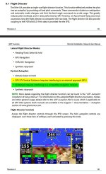
To enable the approach modes and PFD indicators, you must configure the ILS display:
ILS Type: pick Needles or Scales as preferred
When some other features are turned on, only Scales mode is possible.
Show VOR CDI on Localizer: No, unless you have a VOR input.
Show GPS CDI on Loc/GS: Yes
This displays the GPS approach deviations on the ILS indicators.
This is required for the GPS approach display and capture modes in the EFIS.
Jeff DeFouw <
[email protected]>
Programmer
GRT Avionics, Inc.