

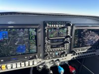
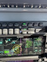
During a flight to northwest Arkansas today, I noticed that the PFD (GDU 460) was not displaying an upcoming TFR on either the MAP or WX:TFR page, but it was visible on the GTN 650xi and MFD (GDU 465).
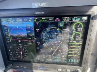
In my system/aircraft the FIS-B data is received by a GTX 345 and shared with the GTN 650xi and both GDUs. The MFD (GDU 465) also gets weather data from Sirius XM. By forcing the GDU 465 to only use FIS-B data, I was able to duplicate the issue on it also.
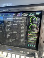
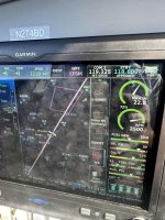
All of the data received was healthy, current and displayed on the GTN 650xi. After about an hour into the flight, the outer boundary of the TFR was displayed on the GDU -- it didn't match the image on the GTN.
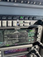
Screen grabs attached, Email sent to G3Xpert.
Some additional data:
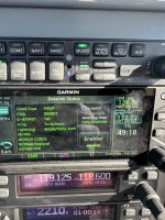
G3X Touch units running with v9.31
GTN Xi is v20.33
GTX is (main) 2.80, (ADSB) v3.51
I would not like to see a fellow pilot get caught by inaccurate TFR information.
We all know the caveats that go with in-cockpit weather data (FIS-B, etc.) and how we aren't supposed to rely on it for planning purposes, yaddah, yaddah. But still...
In my system/aircraft the FIS-B data is received by a GTX 345 and shared with the GTN 650xi and both GDUs. The MFD (GDU 465) also gets weather data from Sirius XM. By forcing the GDU 465 to only use FIS-B data, I was able to duplicate the issue on it also.
All of the data received was healthy, current and displayed on the GTN 650xi. After about an hour into the flight, the outer boundary of the TFR was displayed on the GDU -- it didn't match the image on the GTN.
Screen grabs attached, Email sent to G3Xpert.
Some additional data:
G3X Touch units running with v9.31
GTN Xi is v20.33
GTX is (main) 2.80, (ADSB) v3.51
I would not like to see a fellow pilot get caught by inaccurate TFR information.
We all know the caveats that go with in-cockpit weather data (FIS-B, etc.) and how we aren't supposed to rely on it for planning purposes, yaddah, yaddah. But still...
Attachments
Last edited:
