

Ron Lee
Well Known Member
Two days ago I decided to make a try at going to the west coast (California). Initial stops were at Catalina Island since that is a small overwater flight compared to the Bahamas, Redwood NP (National Park), Yosemite NP and Sequoia NP. Then I checked something and saw that hotel rates were about one-half of weekend rates in Las Vegas so I cut out Redwood NP and planned on making my first stop at Las Vegas to spend the night.
I am not a huge Las Vegas fan but a great deal at Luxor, the multi-color M&Ms at M&M World and the Bellagio fountains would be a change of pace.
Yesterday morning I checked the ADDS satellite map of the western USA with flight conditions and it was not good. Mountain obscuration in Colorado, Southern Utah and northern NM and AZ are iffy for this weather wuss. Some TAFs look better so I decided to wait and see if the sun would improve conditions. Off to Jills for breakfast.
When I returned home I saw a better satellite map that suggested a viable path south towards Albuquerque, southwest towards St Johns AZ then west and north to Las Vegas.
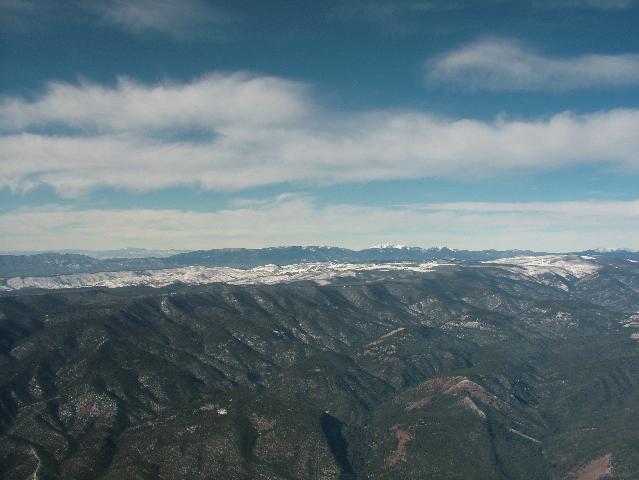
I decide to head south and hope that it clears in the northern NM/AZ area. Take-off at 1045 AM. As I am heading south I can see reasonably well to the west but there is no guarantee that just beyond where I can see it becomes an opportunity to hit a mountain or accumulate ice so I keep heading south. This is looking basically west and you can see what may be low clouds in the far distance...or maybe not.
Stop at Double Eagle NM (AEG) near Albuquerque for fuel and an update of satellite imagery and a FSS briefing. VFR not recommended for the direct flight so I elect to continue the trip south AROUND the weather.
When I get in the plane and input the direct AEG to VGT path in the GPS I made a quick mental calculation that adding in the trip towards St Johns would not leave adequate time to complete the trip in daylight so I bail and returned to Meadow Lake.
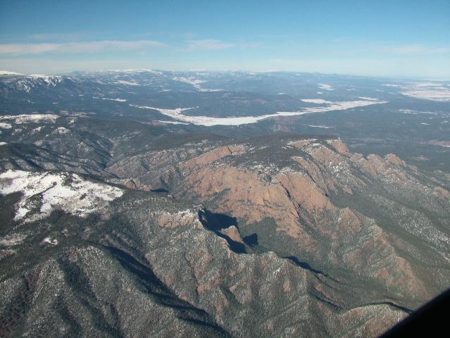
Another shot coming home. I believe that this is northern NM east of the Rockies near Las Vegas NM:
In retrospect here is where I made the mistake that cancelled this trip. The ADDS surface chart did show a low in the area and some orange lines that may be troughs. I should have assumed that no improvement was likely. Once I found out that a viable route was around the system I should have left about two to 2.5 hours earlier than I did. That would have allowed time to get to VGT before sunset.
So I made a mistake in assessing the weather and not quickly making a change in my flight path to work around the weather but I did make safe flight choices overall by not succumbing to "get there-itis" or worrying about losing my hotel room cost.
I did call Luxor when I got home and was able to have the reservation charge refunded because I was prevented from getting there by personal plane (weather).
One difference between this flight and the one to the Bahamas. On the Bahamas trip I was more geared for warm weather to include having snorkeling gear and a wetsuit. On this trip I had a bag with winter gear (snow boots, hats, gloves, ski pants, etc) plus firestarting material, space blanket, sleeping bag.
I am not a huge Las Vegas fan but a great deal at Luxor, the multi-color M&Ms at M&M World and the Bellagio fountains would be a change of pace.
Yesterday morning I checked the ADDS satellite map of the western USA with flight conditions and it was not good. Mountain obscuration in Colorado, Southern Utah and northern NM and AZ are iffy for this weather wuss. Some TAFs look better so I decided to wait and see if the sun would improve conditions. Off to Jills for breakfast.
When I returned home I saw a better satellite map that suggested a viable path south towards Albuquerque, southwest towards St Johns AZ then west and north to Las Vegas.
I decide to head south and hope that it clears in the northern NM/AZ area. Take-off at 1045 AM. As I am heading south I can see reasonably well to the west but there is no guarantee that just beyond where I can see it becomes an opportunity to hit a mountain or accumulate ice so I keep heading south. This is looking basically west and you can see what may be low clouds in the far distance...or maybe not.
Stop at Double Eagle NM (AEG) near Albuquerque for fuel and an update of satellite imagery and a FSS briefing. VFR not recommended for the direct flight so I elect to continue the trip south AROUND the weather.
When I get in the plane and input the direct AEG to VGT path in the GPS I made a quick mental calculation that adding in the trip towards St Johns would not leave adequate time to complete the trip in daylight so I bail and returned to Meadow Lake.
Another shot coming home. I believe that this is northern NM east of the Rockies near Las Vegas NM:
In retrospect here is where I made the mistake that cancelled this trip. The ADDS surface chart did show a low in the area and some orange lines that may be troughs. I should have assumed that no improvement was likely. Once I found out that a viable route was around the system I should have left about two to 2.5 hours earlier than I did. That would have allowed time to get to VGT before sunset.
So I made a mistake in assessing the weather and not quickly making a change in my flight path to work around the weather but I did make safe flight choices overall by not succumbing to "get there-itis" or worrying about losing my hotel room cost.
I did call Luxor when I got home and was able to have the reservation charge refunded because I was prevented from getting there by personal plane (weather).
One difference between this flight and the one to the Bahamas. On the Bahamas trip I was more geared for warm weather to include having snorkeling gear and a wetsuit. On this trip I had a bag with winter gear (snow boots, hats, gloves, ski pants, etc) plus firestarting material, space blanket, sleeping bag.
Last edited:
 estroying Perfectly Good Airplanes
