

n5lp
fugio ergo sum
I liked the old AOPA Flight Planner application but it was a Windows product which made it a pain for me to use as I prefer Macs. I noticed a couple of weeks ago that AOPA announced the beta version of a new web based flight planner. Today I had time to look at it in some depth. I think it is a big winner.
The Internet Flight Planner is an integrated flight planning, flight plan filing, and weather briefing application. Like the old application it keeps your pilot and aircraft information stored. This application can also store your routes.
When you start the application it comes up in the "New Route" window. The other modules are available by buttons across the top of the window. In the "New Route" window you put in your route information such as departure and destination, time enroute, altitude, etc. If you don't know identifiers it can find them for you.
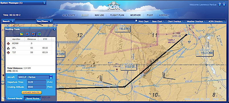
The next button is "Chart" which I consider the heart of the application. Your route will show on the configurable chart. The chart can show terrain or not, airways, obstructions, roads, localizers and other things. Most things can be toggled on or off. It also shows TFRs. You can drag the chart around and zoom in and out. From the chart window you can modify your route by double clicking on fixes, such as airports or intersections. It doesn't seem to work with user fixes. This route modification method isn't quite as nice as the old Windows application where you could just grab and drag the route line around. You can click on some items to get extra information. For instance you can show AOPA information on airports along the route, including gas prices, or get information on restricted areas or MOAs.
Various weather items can also be overlayed on the chart, such as winds aloft forecasts and NEXRAD radar. I believe this is the first time that I have ever seen a weather source that also has some lightning information at no extra cost, although the information seems to be quite basic.
As with the old application, you can print out your kneeboard NavLog and file a flight plan. You can also get the official DUATS briefing. Aside from the DUATS briefing there are graphical weather maps on the right side of the weather page of most things you might want. They are easily modified for altitude or animated in the case of satellite photos or radar information.
There are still a couple of things that are not implemented but I am very happy with this application that is available at no extra cost for AOPA members and that is available on pretty much any computer anywhere that can be connected to the internet.
http://www.aopa.org/aifp/welcome.cfm?


