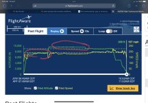
I looked at FlightAware track and altitude reporting was way off and I’ve never seen this before.
When I was at 7000, it shows me me 500 high. When at 9000, 500 low. Not the entire time but at least half.
I filed for 7000, later climbed to 9000 for cooler air. Obviously on an IFR flight from the altitudes, talking with ATC and resetting the baro on the altimeter when changing controllers, and on autopilot.
If my altitude was that far off, I would have gotten altitude alerts from ATC and probably told to call a number when I land.
It did correct itself a little over halfway through the flight but leaves me wondering if others have seen errors like this.
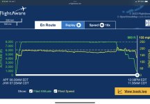