

ChiefPilot
Well Known Member
This past summer, I became somewhat interested in competition aerobatics. Joining the local IAC chapter, I found that one of the biggest challenges was being able to stay "in the box". The aerobatic box as defined by IAC rules is a 1km x 1km box starting from 328'agl to 1500'agl and going up to 2000' to 2952' feet (full details here).
Staying in the box wasn't hard because it is small but rather because knowing where it's boundaries were is difficult unless you're at a chapter meeting where the markers are out or at a competition meet. Moreover, any practice area needs be compliant with FAR 91.303 - away from airways etc. This was somewhat time consuming to do on a normal flight planning app. As an app developer, I knew there was a way to solve this problem.
The result is AcroBox for iPhone and iPad.
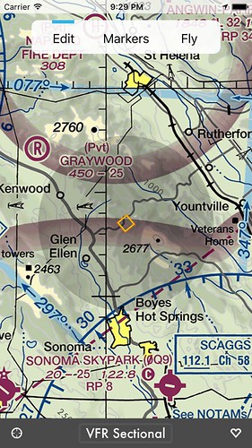
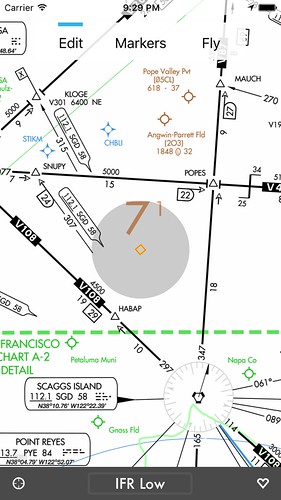
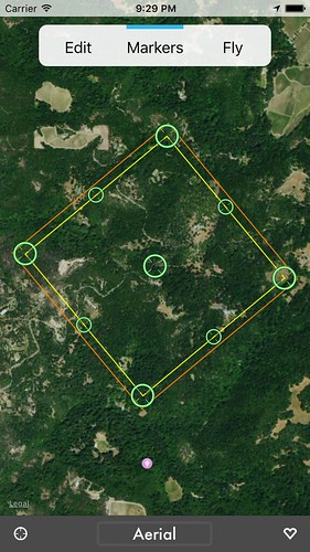
AcroBox lets you define the boundaries of a virtual aerobatic box compliant with the International Aerobatic Club's specifications and FAA regulations. Use the VFR and IFR charts to ensure that the box doesn't encroach on federal airways or airport surface areas, then use the aerial map to visually identify box boundaries. If you're setting up a box for a club or competition event, the "marker" mode shows exactly where the box markers should be placed.
If you have multiple devices, AcroBox lets you easily share box locations between them using iCloud. You can also share box details with other pilots via e-mail, and they will receive not only the coordinates of your aerobatic box but also a map image and a link to open the box in AcroBox or another popular flight planning app! Share your box definitions on Facebook, Twitter, or simply export them directly to ForeFlight - AcroBox is all about sharing.
One feature that is somewhat experimental is the "virtual boundary judge". When in "fly" mode and connected to the aircraft audio system, the app will audibly announce box enter/exit events. I say experimental because the GPSes in phones especially are horrible and lose position readily during manuvering. The GPS in an iPad Air/Air2 works ok but loses position occasionally. I'm interested to find out if external GPSes (Stratus, Stratux, etc.) work any better. If you want to try this, make sure the silent/vibrate switch is off - AcroBox honors the switch's setting.
The app is available on the Apple AppStore free of charge and free of ads. Aviation is expensive enough as it is.
Staying in the box wasn't hard because it is small but rather because knowing where it's boundaries were is difficult unless you're at a chapter meeting where the markers are out or at a competition meet. Moreover, any practice area needs be compliant with FAR 91.303 - away from airways etc. This was somewhat time consuming to do on a normal flight planning app. As an app developer, I knew there was a way to solve this problem.
The result is AcroBox for iPhone and iPad.
AcroBox lets you define the boundaries of a virtual aerobatic box compliant with the International Aerobatic Club's specifications and FAA regulations. Use the VFR and IFR charts to ensure that the box doesn't encroach on federal airways or airport surface areas, then use the aerial map to visually identify box boundaries. If you're setting up a box for a club or competition event, the "marker" mode shows exactly where the box markers should be placed.
One feature that is somewhat experimental is the "virtual boundary judge". When in "fly" mode and connected to the aircraft audio system, the app will audibly announce box enter/exit events. I say experimental because the GPSes in phones especially are horrible and lose position readily during manuvering. The GPS in an iPad Air/Air2 works ok but loses position occasionally. I'm interested to find out if external GPSes (Stratus, Stratux, etc.) work any better. If you want to try this, make sure the silent/vibrate switch is off - AcroBox honors the switch's setting.
The app is available on the Apple AppStore free of charge and free of ads. Aviation is expensive enough as it is.
Last edited:


")
")
