Interesting. For those living quite a few miles away from DC Airspace and unaware of the background, can you explain a bit more what this is about? Why do you need DNA testing and water-boarding interogation just to enter the airspace? What is the FRZ zone? And why would you go to so much trouble to get clearance just to fly there and back for giggles? Seems like a lot of trouble just to be able to go flying on a bad weather day, especially if there was no $100 hamburger at the destination.
Planenutz,
Fair question, yet not the 1st self-imposed flying challenge I'd set.
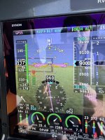
It required exacting flight parameters in every way, altitude, direction, communications.
The DC airspace is congested with multiple major airports, and military fields.
For security reasons the fingerprinting and additional measures from more than 1 federal agency, is to make sure someone will ill intent does not get too close.
It is made very clear that failure to comply does bring with it the possibility for armed jets to shoot down aircraft. Not a joke.
I took approached this flight methodically in my planning and execution (pun intended).
There are others that come to mind in my logbook-such as the Hudson River New York City flight past Manhattan and past the Statute of Liberty.
Memorable.
I intend to return, and the next time more relaxed.
I had done it about 15 years before on an IFR flight plan with a friend. Martin Walker who was an excellent teacher, pilot and good guy. He died a few years ago, I intend to pay that forward for a younger pilot.
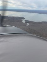
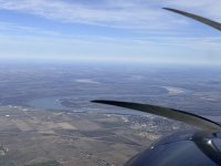
The picture I took captured the remains of ships from World War I left there over 100 years ago.
Daddyman58


 tomorrow….