Yes, you can make your Dynon package IFR with approved IFR navigation equipment. I've previously flown several using D10A, D100 and HDX's, installed several Dynon HDX's recently and will gladly share pics.Building RV-12iS E-LSA. As I do not have an IFR rating, would still want the plane to have IFR capabilities for my training purposes and not going intentionally into IMC. Van's offer the Gamin IFR package for $13,000+ over DYNON VFR package ($24000). Is anyone uses Dynon Avionics for IFR with components bought after E-LSA build and after adding additional components is there much of a price difference? Another reason I am asking is, I am getting ready to close up the Tailcone and want to run cables necessary for the Nav Com antenna in VS.

Van's Air Force
You are using an out of date browser. It may not display this or other websites correctly.
You should upgrade or use an alternative browser.
You should upgrade or use an alternative browser.
IFR question??
- Thread starter YME
- Start date

Yes, pics would be appreciated and is it necessary to run cables thru tailcone for any antennasYes, you can make your Dynon package IFR with approved IFR navigation equipment. I've previously flown several using D10A, D100 and HDX's, installed several Dynon HDX's recently and will gladly share pics.
Not tail cone wiring necessary if you go with the GPS175.Yes, pics would be appreciated and is it necessary to run cables thru tailcone for any antennas
Thank you. I am not familiar with the avionics, so I guess I will call Dynon and Garmin about items needed.Not tail cone wiring necessary if you go with the GPS175.
JackKing,
Thank you for all the information. So for IFR training, I do not need a heated pitot. Good to know. Now I will have to see what Dynon has to offer and see what I need after airworthiness to make it so I can train for IFR. I know the Garmin IFR package is $46,000, so not sure what my total would be for Dynon and then an add on.
As far as heated pitot, not saying don't just legally not required. Resale or again some E-LSA standard it may be warranted. As far as the panel $46,000 ouch. Best of luck with the project!
Last edited:
Each GDU 460 has its own attitude and heading reference system (AHRS) built in, and then uses GPS for sensor drift correction. Technically, you could use an iPhone as a backup AHRS in an emergency.Did your second screen have its own AHRS? If so where did you mount it?
Last edited:
The GDU 460’s do not contain an AHRS. The AHRS is a separate LRU. It would have to be a very bad day before I would trust a cell phone to keep me upright in IMC.Each GDU 460 has its own attitude and heading reference system (AHRS) built in, and then uses GPS for sensor drift correction. Technically, you could use an iPhone as a backup AHRS in an emergency.
Each GDU 460 has its own attitude and heading reference system (AHRS) built in, and then uses GPS for sensor drift correction. Technically, you could use an iPhone as a backup AHRS in an emergency.
That is a different but interesting topic. Has anyone flown simulated instrument, with safety pilot per FAR's of course, with just a iPhone, iPad, Android? Lighting strike and blank or RED X and it's all you have I would take it. However I would want to verify.The GDU 460’s do not contain an AHRS. The AHRS is a separate LRU. It would have to be a very bad day before I would trust a cell phone to keep me upright in IMC.
There are a few of stand alone "pocket" self powered ADI's like the Dynon Avionics D3 Pocket Panel Portable EFIS, powered/charged externally with internal battery.
I don't have any ADI/EFIS App for my iPad, at least directly. My iPad through bluetooth can repeat the EFIS (GRT Horz 10.1). The other way is Stratux ADS-B as a permanent installation for ADS-B IN. It is hard wired to EFIS. However Stratux has WiFi as well and the software (raw data) I never use as an ADI display page. Unless you were already connected and displaying, that, it would not be something you could pull up on the fly.
Normally the iPad is running EFB map display or airport info, no ADI. There are a bunch of standalone ADI Apps for the iPad.
What about the classic back up, an electric analog T&B or TC? Why not? Needle Ball and Airspeed (and VSI and ALT). I recall the early Glass in planes like Ciriius had three analog gauges. That was all you had, "partial panel" in steam driven planes. I do believe a Dynon D3 or similar would be better, and may be iPad?
Their is a youtube video out there (Here) that compares many different brands/models of backup EFIS instruments. Some are GPS based and some are AHRS based. The results were pretty clear on which ones I would not trust my life on. I had a prominent employee at one of the major players in the avionics world tell me "I would never trust any of those toy make-believe AHRS's". In this case he was referring to the mickey mouse AHRS built into the GLD39 3D. Likewise it is not difficult to completely confuse the gyro's inside a modern Ipad or Iphone with a sustained standard rate turn.That is a different but interesting topic. Has anyone flown simulated instrument, with safety pilot per FAR's of course, with just a iPhone, iPad, Android? Lighting strike and blank or RED X and it's all you have I would take it. However I would want to verify.
There are a few of stand alone "pocket" self powered ADI's like the Dynon Avionics D3 Pocket Panel Portable EFIS, powered/charged externally with internal battery.
I don't have any ADI/EFIS App for my iPad, at least directly. My iPad through bluetooth can repeat the EFIS (GRT Horz 10.1). The other way is Stratux ADS-B as a permanent installation for ADS-B IN. It is hard wired to EFIS. However Stratux has WiFi as well and the software (raw data) I never use as an ADI display page. Unless you were already connected and displaying, that, it would not be something you could pull up on the fly.
Normally the iPad is running EFB map display or airport info, no ADI. There are a bunch of standalone ADI Apps for the iPad.
What about the classic back up, an electric analog T&B or TC? Why not? Needle Ball and Airspeed (and VSI and ALT). I recall the early Glass in planes like Ciriius had three analog gauges. That was all you had, "partial panel" in steam driven planes. I do believe a Dynon D3 or similar would be better, and may be iPad?
All that being said, if the crap hits the fan and there is no better option, you betcha I am going to use whatever I have to attempt to get out of trouble.
Last edited:
I have put some thought into this - curious for the hive mind’s thoughts. The BOM offers a redundant AHRS, ADSB-in and GPS and it is heated. It wouldn’t feed into the panel-mounted avionics but a Dynon panel with the 175 backed up with a RAM-mounted iPad + BOM seems like a good solution for the heated pitot and lack of AHRS backup and none of it would require running wires after the ELSA certification.
Last edited:
I have an iPad that connects to a Stratus 2. These are turned on, connected and running during warmup/runup and left independent from the G3X and GPS175 system. As Brian points out it would be a very bad day before I relied on the iPad/Stratus 2 but a very bad day is exactly why I have this set up in the first place.All that being said, if the crap hits the fan and there is no better option, you betcha I am going to use whatever I have to attempt to get out of trouble.
This is incorrect. Each GDU 460 is indeed a self contained AHRS and is described in Garmin's documentation for the unit. For fun, apply power and ground to any GDU 4XX while holding it in your hands, and then move it around; it will do a great job of displaying your attitude and heading.The GDU 460’s do not contain an AHRS. The AHRS is a separate LRU. It would have to be a very bad day before I would trust a cell phone to keep me upright in IMC.
I believe you are confusing this with the GSU 25. This optional unit provides Pitot and Static Air Data information and Attitude Heading Reference (ADAHRS) in a single mechanical package and augments the data available within the G3X system. However, a GDU with a GPS antenna will provide accurate stand-alone AHRS service.
The GDU 460 does have mounting holes on its backside if you desire to mount a GSU 25 to it directly, which is a convenient option for those that want a redundant unit. You could connect two GSU 25's to the same GDU, but with dual GDU's, you would probably want to connect one GSU to each GDU for further redundancy; in normal operation, all of the data gets shared via CAN bus to every device on the system.
I've done an approach using an iPhone under a hood with a safety pilot and it worked out well. I recommend trying for practice in preparation for that "bad day".
Last edited:
This is incorrect. Each GDU 460 is indeed a self contained AHRS and is described in Garmin's documentation for the unit. For fun, apply power and ground to any GDU 4XX while holding it in your hands, and then move it around; it will do a great job of displaying your attitude and heading.
I believe you are confusing this with the GSU 25. This optional unit provides Pitot and Static Air Data information and Attitude Heading Reference (ADAHRS) in a single mechanical package and augments the data available within the G3X system. However, a GDU with a GPS antenna will provide accurate stand-alone AHRS service.
The GDU 460 does have mounting holes on its backside if you desire to mount a GSU 25 to it directly, which is a convenient option for those that want a redundant unit. You could connect two GSU 25's to the same GDU, but with dual GDU's, you would probably want to connect one GSU to each GDU for further redundancy; in normal operation, all of the data gets shared via CAN bus to every device on the system.
I've done an approach using an iPhone under a hood with a safety pilot and it worked out well. I recommend trying for practice in preparation for that "bad day".
Ok, show us where in Garmin's documentation that they state that the GDU 460 has a built in AHRS....
Also, show us a video where a GDU 460 out of the box with nothing but power applied will do a great job of displaying attitude and heading.....
I am not confusing the GDU 460 with anything. Do a little searching and you will find that I am pretty familiar with the G3X and G3X Touch systems.
Hi, could you share your experience of usage of the dynon skyview classic + GPS 175 in IFR? i'm setting up my 7 like this and I would like to understand if it is everything ok or do i need to change the setup of the cockpit. Thank you in advanceYes, you can make your Dynon package IFR with approved IFR navigation equipment. I've previously flown several using D10A, D100 and HDX's, installed several Dynon HDX's recently and will gladly share pics.
Thanks for your answer!Yes, you can make your Dynon package IFR with approved IFR navigation equipment. I've previously flown several using D10A, D100 and HDX's, installed several Dynon HDX's recently and will gladly share pics.
I need some advice regarding chart update. My setup is formed by 2 sky view and a gps 175, and I would like to know if anyone in Europe and mostly in Italy has experience with IFR charts update.
Do I need to to update both Dynon and Garmin or only the last one is enough?
Which IFR charts are most suitable for update in Europe?
Thanks in advance
I can't help with Europe or Italy, but in USA all data is free on line. Regarding getting it into your GPS Nav Data that is fairly straight forward (for a fee) with Garmin.Thanks for your answer!
I need some advice regarding chart update. My setup is formed by 2 sky view and a gps 175, and I would like to know if anyone in Europe and mostly in Italy has experience with IFR charts update.
Do I need to to update both Dynon and Garmin or only the last one is enough?
Which IFR charts are most suitable for update in Europe?
Thanks in advance
Having multi GPS Nav needing database updating can be expensive. Your GPS175 is the IFR approved GPS.... The other Dynon is VFR and only as a reference in IFR. I would only update the GPS175. Go to Garmin web page, they have Europe data bases. As far as Dynon no you don't "have to" update. You don't have to update the Garmin if VFR.... explanation:
VFR you don't have to update anything, however it is up the PIC to comply. There are updated Charts (Sectionals, Low IFR) and Inst Approach charts and "supplemental data" (called Airport Facility Director, now Chart Supplement) is free on line.
You may have free data on line for Europe. As long as you have the latest info, be it paper, PFD charts on your iPad and don't violate airspace you are good without an update.
Cost, no factor, update them all, all the time. I am not sure about Dynon's data base for Europe. Garmin has World Wide Database. If you want the min updates and fly IFR with the GPS175, updating that would be the min update you need to do. (if I understand you). BOTTOM LINE you do not have to update anything, but you as PIC are responsible. If you can fly legally with airspeed, altimeter and wet compass you don't need GPS or it's database.
----------------------------------------------------------
What I do in regards to data and IFR, flying IFR with a GPS175. I do not update regularly the 175. There are times of the year I travel and may need to file IFR and fly IMC. I get a onetime update as needed. Rest of the year VFR or practice IFR approaches in VFR with a safety pilot I let it lapse. I check chart and plate updates, NOTAMS on-line. I have EFB which gets IFR chart updates (sectional, Low Alt, IFR IAP's, Airport Data, NOTAMS) FREE.
Things rarely change or change significantly, surprisingly! Not really but you are responsible. Since it is practice IFR approaches (under hood) in VFR conditions for currency, I do not need an update data-base to be legal. However I am always responsible to not violate airspace rules. I have EFB which gets IFR chart updates FREE.
My GRT Horizon 10.1 EFIS has it's own VFR data-base, terrain data, with free updates. GRT has an option for additional IFR data, for a one time initial fee for the option. Updates are free indefinitely after that as long as GRT can get the data free. This data is free to all as public domain at this time.
It is legal to use the GRT EFIS IFR, with GRT IFR data base loaded? YES, but only if the GPS source like a Garmin GPS175 is providing the GRT with legal IFR GPS Nav/Approach position (WAAS). I elected to not add that GRT IFR option at this time, just go with Garmin GPS175 for form, fit, function, pulling up approaches, missed, holds are easier from practice. GRT button-ology is different and does not have holds I recall. Not a show stopper, but have to have the Garmin anyway regardless.
Garmin GPS175 talks to the GRT EFIS through an ARINC (Garmin GAD 29) interface, to display NAV data (LPV, LOC GS) and GPS position regardless of data base on both the GRT EFIS and the back up G5. The GRT is a glorified HSI in a way on approaches, but it also shows MAP, airport, waypoints, terrain, traffic, on and on. For now I go with GRT VFR updates (no charge) and Garmin GPS175 when needed ala cart.
Last edited:
My RV-12iS (N18HH) has dual Dynon Skyview HDXs, Garmin 200 Com, and Dynon A/P. I would like to add the GPS175 and SV-Airinc module and be able to file IFR. Everyone seems to have strong feelings about entering IMC. Around the Seattle area we have lots of days in the summer that have individual puffy white clouds that one might fly through if flying on an IFR plan between Tacoma and Bremerton, for example, not crummy weather but beautiful summer weather. Technically you go into IMC, but very briefly. And without a hood, it is perfect for keeping sharp flying in the IFR system. I would stay completely away from weather that might have icing. Doesn't all this make sense, or am I missing something?If your goal is truly training without intent of flying into IMC, the only thing you need to add to a basic Dynon package would be a TSO’d navigator, the cheapest being the GPS175, and an SV-Airinc module. Cheapest price I see online for the pair is $5350, so call it $5500 by the time you have it wired up. (Dynon does not offer a navigator permissible for use in the IFR system).
Don’t need backup ADAHRS or efis, don’t need heated pitot, but you could always add these down the road if you decided you wanted to venture into the fuzz.
I don’t think equipping an aircraft strictly for a training purpose is unreasonable… as already mentioned, all the factory RV-12is IFR package have a single adahr and unheated pitot.
Nothing really wrong here, except human nature. First, isolated cumulous clouds. Then, one day, a thin overcast. Then an overcast that's a lot thicker. Opps, got some icing here. And the cloud base just dropped to 200' AGL, vis 1/2 in fog. Why not? I have the rating..... If you really can avoid 'mission creep' and stay within the airplane's limits (and your own), great. But then, why spend $5K on a gps? Just get a used VOR/ILS receiver.My RV-12iS (N18HH) has dual Dynon Skyview HDXs, Garmin 200 Com, and Dynon A/P. I would like to add the GPS175 and SV-Airinc module and be able to file IFR. Everyone seems to have strong feelings about entering IMC. Around the Seattle area we have lots of days in the summer that have individual puffy white clouds that one might fly through if flying on an IFR plan between Tacoma and Bremerton, for example, not crummy weather but beautiful summer weather. Technically you go into IMC, but very briefly. And without a hood, it is perfect for keeping sharp flying in the IFR system. I would stay completely away from weather that might have icing. Doesn't all this make sense, or am I missing something?
So a Garmin 430W would fit (barely) , I think, in the 2 7/8” space available between the top of the 200 Com and the hand hold (which made ingress and egress super easyNothing really wrong here, except human nature. First, isolated cumulous clouds. Then, one day, a thin overcast. Then an overcast that's a lot thicker. Opps, got some icing here. And the cloud base just dropped to 200' AGL, vis 1/2 in fog. Why not? I have the rating..... If you really can avoid 'mission creep' and stay within the airplane's limits (and your own), great. But then, why spend $5K on a gps? Just get a used VOR/ILS receiver.
 ).
).Attachments
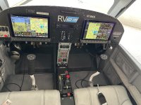
So a Garmin 430W would fit (barely) , I think, in the 2 7/8” space available between the top of the 200 Com and the hand hold (which made ingress and egress super easy
As a CFII, I agree strongly with Bob Turner about human nature. I often have new instrument students who tell me they only want the minimum to "go on top" or "descend through a high deck". "I don't intend to do any hard IFR". I never believe them. I know that they will end up someplace and unexpected IMC weather will require real skills to get out or to get home. The choice is to rent a car and drive, thus leaving the airplane at an airport 100+ miles from home, or ... I have an instrument rating so I can fly. Because of this, I never train a student to be good enough. My standard before signing them off for a checkride is "would I trust them in real IMC with my wife in the passenger seat?"Nothing really wrong here, except human nature. First, isolated cumulous clouds. Then, one day, a thin overcast. Then an overcast that's a lot thicker. Opps, got some icing here. And the cloud base just dropped to 200' AGL, vis 1/2 in fog. Why not? I have the rating..... If you really can avoid 'mission creep' and stay within the airplane's limits (and your own), great. But then, why spend $5K on a gps? Just get a used VOR/ILS receiver.
I view instrument redundancy the same way. The FAA requires partial panel skills. This is for good reason. I would not fly an aiplane in IMC without the ability to safely navigate to, and complete an instrument approach with any single component failure.
Also, remember that that if you file IFR (Instrument Flight Rules), ATC assumes that you are capable of operating under Instrument Flight Rules and they can direct you into IMC. If you are not current and equipped, don't file IFR.
Triumph1974
Well Known Member
I was able to add basic IFR capabilities with the Skyview system by installing a MGL remote NAV16 radio, and MG Razor head (the interface to NAV radio) and a homemade wingtip antenna that the local Ham radio club graciously helped me to accurately tune for great reception of over 100 miles if the channel is near 112.5 - the frequency I chose to tune the radio to for best reception). The radio will feed data to the Skyview display as an HSI and glideslope for both vertical and lateral guidance. You will get a redundant glideslope display, and 2 VOR ( the radio can automatically flip flop between two VORs so it appears to give you 2 VORS so your Skyview HSI can have 3 needles for HSI navigation guidance (VOR 1 and 2, and the Skyview WAASP GPS) for less than $1.6K with this set up
(assuming you already have the Skyview WAASP GPS antenna.) Of course you will not be able to legally fly GPS approaches without an approved GPS navigator, so this is not a viable option if all the airports you frequent only have GPS approaches.
You can use Airmate data to pull up current plates on the Skyview screen (have backup current paper charts). The original Skyview system requires using the left button for setting heading, track, altitude and other bugs is a little clunky during the learning process as you are using 1 control button to get to the page layers you need to get to in the Skyview to follow good IFR panel procedures to stay ahead of the airplane but is is light years ahead of what IFR pilots used up 15 or 20 years ago.
You can add other redundancy instruments one by one to suit your needs. The risk of having all your backup instruments tying back to a single failure point can reduced with this sort of set up vs. "all in one Garmin equipment box".
mike_tailwind
Member
This is off the original topic. @Triumph1874, Are you able to get correct VOR CDI deflections on the Skyview from the N16 and Razor? I have a GRT EFIS and the CDI deflections are backwards as is the display on the Razor. The problem is with the Razor and it has not been fixed in one year since I brought it to MGL's attention. I've since programmed an Arduino micro to correct the serial data between the Razor and the EFIS and it works OK.I was able to add basic IFR capabilities with the Skyview system by installing a MGL remote NAV16 radio, and MG Razor head (the interface to NAV radio) and a homemade wingtip antenna that the local Ham radio club graciously helped me to accurately tune for great reception of over 100 miles if the channel is near 112.5 - the frequency I chose to tune the radio to for best reception). The radio will feed data to the Skyview display as an HSI and glideslope for both vertical and lateral guidance. You will get a redundant glideslope display, and 2 VOR ( the radio can automatically flip flop between two VORs so it appears to give you 2 VORS so your Skyview HSI can have 3 needles for HSI navigation guidance (VOR 1 and 2, and the Skyview WAASP GPS) for less than $1.6K with this set up
(assuming you already have the Skyview WAASP GPS antenna.) Of course you will not be able to legally fly GPS approaches without an approved GPS navigator, so this is not a viable option if all the airports you frequent only have GPS approaches.
You can use Airmate data to pull up current plates on the Skyview screen (have backup current paper charts). The original Skyview system requires using the left button for setting heading, track, altitude and other bugs is a little clunky during the learning process as you are using 1 control button to get to the page layers you need to get to in the Skyview to follow good IFR panel procedures to stay ahead of the airplane but is is light years ahead of what IFR pilots used up 15 or 20 years ago.
You can add other redundancy instruments one by one to suit your needs. The risk of having all your backup instruments tying back to a single failure point can reduced with this sort of set up vs. "all in one Garmin equipment box".
Before I go on my rant you can have a very effective IFR trainer with a GPS only that can perform RNAV approaches, i.e., TSO-C129/145. However for Inst check ride in your RV-12 E-LSA you would need at least some ground based approach NAV, VOR / LOC, at least for the check ride. An ILS is not necessary as a RNAV LPV approach for the purposes of training or check ride is a suitable substitute for an ILS if the Mins are no higher than 300ft HAT. However there is a WORK AROUND.Building RV-12iS E-LSA. As I do not have an IFR rating, would still want the plane to have IFR capabilities for my training purposes and not going intentionally into IMC. Van's offer the Gamin IFR package for $13,000+ over DYNON VFR package ($24000). Is anyone uses Dynon Avionics for IFR with components bought after E-LSA build and after adding additional components is there much of a price difference? Another reason I am asking is, I am getting ready to close up the Tailcone and want to run cables necessary for the Nav Com antenna in VS.
I do not have VOR/LOC/GS(ILS) in my RV and file and fly IFR all the time very nicely. Most small GA airports today are RNAV only. Bigger airports with ILS have a RNAV LPV overlay. Yes ILS is lower mins overall but LPV is no slouch. If you can't get in with a LPV you probably should not have been flying that day. LPV is far better than a VOR (now a rare approach) or LOC only approach (typically in conduction with ILS which is typically at larger towered airports). As a CFII it is a challenge to even find VOR approaches, and LOC/ILS is almost short cross country to get to. RNAV LPV and LNAV all over...
Remember the IFR rating MAIN training is all about BASIC FLYING by sole reference to instruments: straight and level, level descents at precise airspeed and ROD, turns, climbs, level offs and timing. You don't need fancy equipment to do that. You only need 15 hrs of dual of the 40 hrs of simulated/actual/simulator hours for the INST rating. You don't need VOR/LOC/GS or even RNAV capability to train and practice basic flying skills, but you can not take your check ride in a plane without capability of "3 types" of approaches. ***
I started flying RV's in early 1990's, and also became a CFI-I-ME about the same time. My first Van's was an RV-4 I flew IFR (no autopilot a little busy but pitch trim is your friend and knees were wing leveler). Being in Washington state at the time, IFR capability came in handy.
I have maintained my CFI for over 30 yrs. I was most active first 4 yrs, and recently got back into doing ratings at a local flight club (one student at a time, Flt reviews, IPC, checkouts). One of my students passed his Instrument check ride. Your thinking about your RV-12 and learning is great.
Yes you can train and get your rating in your RV-12iS, of course in VMC conditions as you say (with view limiting device and safety pilot or CFI). It is your money, do as you like. I encourage your to finish your plane and learn. Your ability to fly precisely and understanding of the NAS (National Airspace System) will expand many fold. Besides it is fun to "breakout" and see the runway in front of you. HOWEVER consider a RNAV only approach setup, no VOR/LOC/GS.
Per Part 61 and ACS (Airman's Cert Standards) you DO need to do a LONG Cross country and file an IFR flight plan along airways, with ATC, fly Instrument approaches to each airport, for the Inst rating. Can you FILE IFR in an E-LSA to fulfill this requirement in training?
Yes. As long as it is VFR, E-LSA meets all the required equip and inspections (pitot/static/transponder) for IFR and one pilot (instructor presumably who will sign your off for check ride) must be IFR rated and current. As a CFI, I can NOT file IFR unless I am current even in VFR conditions. Check-ride can be done in an E-LSA if the DPE agrees. Not a DPE yet, but I know a local DPE who loves RV=12's. I see him giving check rides in them all the time (S-LSA's). DPE's almost always fly VFR during check rides, even for INST rating. However you will need RNAV and at least VOR/LOC capability in the plane for the check ride, or "3-types" of approaches. There is a work around however.
As an Inst instructor I like my students to get some actual IMC during training. My recent Inst student above had over 4 hours IMC, including approaches in IMC, one near approach to minimums IMC. You will not be able to do this in a LSA. However I highly recommend SIMULATOR training. Make sure you find an instructor that, one knows how to run the simulator efficiently and two, has proper lesson plan, can conduct a proper simulator training. I use to teach in fixed base and full flight motion Simulators. There is an art to making it real and meaningful, including simulating real ATC communication (with instructor playing ATC) and emergency "scenarios". Airlines call it LOFT (line orientated flight training, e.e., realistic). It is not playing a video game. You will shoot approaches down to min's in the simulator and with weather (winds, turbulence) , with possible real world scenarios. It counts towards you rating (if simulator is an approved training device). Even if you fly a plane that can fly in IMC, I recommend simulator for al those reasons. I dry lease a local flight school Red Bird LD, set up like a Cessna 172.
The challenge all new Inst Pilots is staying current. If you want to stay current you are required, within last the 6 mo do your "Six-HIT" (6 approaches, hold, intercept, track). Note legal currency is not proficiency, but this is bare min. You will need a view limiting device and a safety pilot of course (they must be a current pilot but need not have an Inst rating). They must sign your log book with their Cert # and you can only log time you are "under the hood". I hate foggle's by they way, but they are convenient. Recommend a hood. You will have to fly all approaches to Mins in VFR under hood to make them count. You can fly local approaches in VFR, no IFR flight plan and not talking to ATC. If towered airport you can negotiate with tower, but best to call ATC and get a VFR Practice Inst Approach, especially if near class B. You can call ATC in VFR conditions, ask for training approach in VFR. There is a difference in that you have no priority. This helps keep your IFR Com skills up and they do provide some traffic alerts (but your are responsible for seeing and being seen since you are VFR). Mid-air collisions between aircraft doing IFR training (where both pilot's are heads down) and VFR pilot head down, also not talking and listening on radio, is a real danger. I have heard of IFR training vs VFR traffic mid airs for 40 yrs. I do worry about it. DO NOT assume ADS-B traffic will save you. When I fly a one of our club planes without ADS-B traffic I bring my own, Stratux and iPad. Lecture switch off.
Other ways to stay current is fly with a CFII and do an IPC every 6 mo. Most Inst pilots who fly IFR in actual IMC (Part 23 and EAB airplanes) find it a challenge to meet the 6HIT requirement in IMC. At the Airlines we get 6 mo checks, and it is possible to fly 6mo Part 121, with no more than a few minutes of IMC. I find it a challenge to stay IFR current just GA flying. .I use all 4 methods, Simulator, actual IMC, Safety pilot, and IPC with a CFII. Does Airline 121 currency count for Part 91? Yes but to be realistic IFR single pilot in an RV-7 is not like flying a large two crew airliner. I have done IPC of airline pilots in their personal plane (twins, high perf singles) and rusty is the word I would use, but with practice they come up to speed.
Bottom line, having this IFR knowledge and skill will make you a better safer VFR pilot. Filing and flying an IFR flight plan in VFR can be practical. When I lived in Washington State, would fly my RV-4 I had at the time to Los Angeles area to see friends and family there at satellite airports all around LAX. VFR with no flight plan and not being a local pilot, VFR was a challenge (no IFR GPS then, handheld Garmin GPSMAP 195). With a sectional it was doable, to fly around LA basin, getting handed off tower to tower. However filling IFR, vectored to an approach in VFR simplifies arrival, verses hunting and pecking around down low VFR, calling tower at the XYZ, still not really seeing the actual airport or runway, looking for traffic and staying out of PC airspace.
*** Some people get 60% to 90% of their training in a non / not fully IFR, or "IFR light" planes, with a safety pilot/CFI , then transition to a "Full IFR plane" for some or all of the required 15 hrs dual. HOW does that work?
Say you don't load your RV=12 up with any or full IFR navigation, may be just a IFR GPS navigator with RNAV approach capability (LNAV, LPV), no VOR/LOC/GS. You can do 25 hours of training in that "IFR Light" plane with a safety pilot or CFI. It counts. You can do all the basic "Attitude Instrument Flying", "Scan-Cross Check-Interpret-Control, i.e., climbs, descents, turns, and RNAV approaches in VFR conditions with view limiting device. It all counts. Than supplement training in a simulator and a rented plane, say a C-172, for the long cross country (requires 3 different approach types not just RNAV). Practice VOR/LOC/ILS approaches in the rental, prep for check ride in rental, and then take check ride in rented plane. Make sense?
I did something like this 35 yrs ago, pre IFR GPS RNAV approaches. I owned with a partner, a Piper Tomahawk with VOR/LOC and Marker beacons (when MB's and LOM's existed). With a safety pilot (partner in plane who who was also working on his IFR rating) we practiced and practiced, basics: climbs, descent, turns, holds, intercepts, tracking and VOR/LOC approaches in VFR (with ground NAV, no GPS). Then I flew with my instructor in a rented C-172 for the required 15 hrs of dual and check ride prep. I took my check ride in the rented C-172. If I wanted to, I could have added a Glide Slope receiver to the Tomahawk, but elected not to do that. I continued to fly the Tomahawk after getting my Inst rating. I filed IFR and flew IMC commuting 30 miles away one way, LOC approaches only. It worked great. If weather was too low I'd drive to work. Repeat: For the IFR rating it is BASIC FLYING SKILLS, straight and level, level descents are precise airspeed and ROD, turns, climbs, level offs and TIMING not NAV gear. You don't need fancy equipment to do that.
For check ride you will need to master your GPS Navigator which is a whole challenge for pilots. So I recommend you do get a GPS175, GNC 355, GNX275 to make your RV-12iS a good IFR trainer that will get you 90% there for a rating. Then the plane you rent should have similar or the same GPS navigator. Flying skills are a MUST, but next is "Button-ology". You need to know how to run the menus, load routes and approaches into the GPS on the fly, quickly, proficiently without errors or whoops. This is not flying skill but programing skill. Depending on your technological prowess this can frustrate students and experienced pilots alike (me included).
Note 1 or 2 COMS: You do NOT need two COMS, but it makes life easier. Example you are IFR, IMC, initial arrival within ATIS/ASOS range of airport. You must get the weather and know what approach is being used, but you are on Freq with ATC, being vectored to the airport. YOU MUST always have a listening watch on the COM with ATC.. Mandatory. You need to listen to ATIS during arrival phase of flight, to set up for approach. Some COMS have a listen to standby mode while staying on primary (can hear and transmit on primary). If primary com is received it blocks the standby Freq listening mode. This makes one radio practical. How do you handle one COM IFR with no standby listen feature? Make ATC Request, to go off Freq briefly to get ATIS? That is approved. You leave Freq, get ATIS, check back in. I do it all the time in a one COM radio IFR trainer (two G5's one GNS430W). My RV-7, GPS175 Navigator (RNAV only no VOR/LOC/GS). The COM one ICOM A220 with standby listen mode. Flight Inst, GRT Horizon 10.1 and one G5. IFR light but really very capable with dual axis autopilot. I don't go looking for the lowest most severe wx to fly in. Credit card and hotel is fine as needed.
BTW you could build your RV-12iS as an EAB and fly IFR in IMC. That has pros and cons. Now with MOSAIC this is more of an option. Your RV-12 EAB could still be flown by Sport Pilots but also could now go IFR (for a PVT pilot with INST Rating). The other part is maintenance. Pilot owners who by a E-LSA or EAB can take the "Inspector LSA" course (two days I think), buy a E-LSA or EAB they did not build, do condition inspections on that plane, even if they did not build the plane (i.e., repairman's certificate). Sport pilots can now fly a C-182. It is all grand. Sport Pilot, LSA and EAB limits and definition have changed, with no LSA weight limits anymore, just stall in clean configuration, which has was raised significantly. Thus a Sport Pilot can fly many EAB and Part 23 planes.
Last edited:
Are you certain this is accurate?However for training you do need to fly at least one other ground based approach, VOR or LOC, for the check ride.
It is possible to get an instrument rating in a GPS only equipped aircraft. I had a student in an RV-12 with only a Garmin 175 do it.Are you certain this is accurate?
Discuss with the DPE… The rules have relaxed a bit.
CFR 61.51 "Pilot logbooks" simply says "The name of a safety pilot, if required by § 91.109 of this chapter." There is no requirement for a safety pilot to sign a log book or provide their Cert # in this CFR. I especially like that is says "The name of a safety pilot...", not "The name of the safety pilot...". My mind races with possibilities!You will need a view limiting device and a safety pilot of course (they must be a current pilot but need not have an Inst rating). They must sign your log book with their Cert # and you can only log time you are "under the hood".
")
I think I agree with this for my RV flying.If you can't get in with a LPV you probably should not have been flying that day.
It is possible to get an instrument rating in a GPS only equipped aircraft. I had a student in an RV-12 with only a Garmin 175 do it.
Discuss with the DPE… The rules have relaxed a bit.
I got my Instrument Rating in August of this year in the RV9A I built with a Garmin 175 as the navigator tied to my dual Dynon HDX system. IR check ride can be done in a GPS only equipped plane with a knowledgeable DPE.
FWIW there was a FAA rule change about a year ago regarding such.
Amedeus,I have an iPad that connects to a Stratus 2. These are turned on, connected and running during warmup/runup and left independent from the G3X and GPS175 system. As Brian points out it would be a very bad day before I relied on the iPad/Stratus 2 but a very bad day is exactly why I have this set up in the first place.
Word of caution on the iPad/Stratus as a back up. Whilst I too run this as a back-up system it has to be configured correctly to work.
Short Version: Be sure the iPad is not connected via EITHER wi-fi or Bluetooth to the Garmin - if it is it will not function as a backup. You can address this in the moment - just be sure you know what to do and remember to do it.
Longer version: I have a full Garmin IFR panel in my 14 (G3X, GTN750, auto-pilot, etc) and have a panel mounted iPad and a Sentry as a back-up - likely for all the reasons you do. I usually flight plan on the pad or my iPhone and it all connects automatically via Bluetooth to my Garmin when I fire up the cockpit avionics. Very nice and convenient. And, in flight, even though I have a G3x MFD I tend to use foreflight’s map on my large panel mounted iPad as my primary map and the G3X to display other stuff.
So, all that said - my Garmin GPS malfunctioned recently on a cross-country flight. It began cutting out intermittently, severing the gps connection to my auto-pilot each time. No problem, I thought as I was running foreflight on the iPad linked to the sentry via wi-fi (I always confirm the iPad WiFi is connected to the sentry on my preflight). I knew I couldn’t continue with my auto-pilot slaved to the now misfunctioning Garmin GPS, but no problem I thought, I’d simply hand-fly and navigate with foreflight/Sentry and everything would be good. Incidentally, I was a bit concerned as I was suspecting I was going to have to get a pop-up IFR clearance to land at my destination where the weather had deteriorated from what had been forecasted.
I was running foreflight in split screen mode on the iPad so I could see both the map and the ADAHARS display. That’s when I noticed the ADAHARS display was flickering on and off.. Ruh-Roh. My primary gps is intermittent and now my backup ADAHARS (and gps) is glitchy, too. What gives?
After much head scratching I finally realized that since the iPad was connected to BOTH the Garmin and the sentry (Garmin via BT and the Sentry via Wi-Fi) - the iPad was taking its data for the ADAHARS from the Bluetooth - and, the gps glitch w the Garmin was now impacting the foreflight ADAHARS display - in spite of the iPad being connected to the sentry via wifi. So, I disabled the BT on the iPad and that solved the issue.
Point of all this…if you are going to use the iPad/sentry (and I assume stratus is the same) - be sure to fully isolate it from your panel (BT and WiFi) to ensure it’s a redundant and separate system. I will still run with the iPad slaved to both systems (for all kinds of reasons) - but, if I have an issue I now know to immediately sever the BT connection to the Garmin.
I’m glad this happened to me when it did, and not in hard IMC. That would have not been pretty.
Thank you for sharing this. You and I are utilizing the iPad, Stratus/Sentry and Foreflight in the same manner. Given that the Stratus connects to the iPad via WiFi a quick "Settings > Bluetooth > Off" on the iPad should resolve this issue.Point of all this…if you are going to use the iPad/sentry (and I assume stratus is the same) - be sure to fully isolate it from your panel (BT and WiFi) to ensure it’s a redundant and separate system.
JACKKING,Before I go on my rant you can have a very effective IFR trainer with a GPS only that can perform RNAV approaches, i.e., TSO-C129/145. However for Inst check ride in your RV-12 E-LSA you would need at least some ground based approach NAV, VOR / LOC, at least for the check ride. An ILS is not necessary as a RNAV LPV approach for the purposes of training or check ride is a suitable substitute for an ILS if the Mins are no higher than 300ft HAT. However there is a WORK AROUND.
I do not have VOR/LOC/GS(ILS) in my RV and file and fly IFR all the time very nicely. Most small GA airports today are RNAV only. Bigger airports with ILS have a RNAV LPV overlay. Yes ILS is lower mins overall but LPV is no slouch. If you can't get in with a LPV you probably should not have been flying that day. LPV is far better than a VOR (now a rare approach) or LOC only approach (typically in conduction with ILS which is typically at larger towered airports). As a CFII it is a challenge to even find VOR approaches, and LOC/ILS is almost short cross country to get to. RNAV LPV and LNAV all over...
Remember the IFR rating MAIN training is all about BASIC FLYING by sole reference to instruments: straight and level, level descents at precise airspeed and ROD, turns, climbs, level offs and timing. You don't need fancy equipment to do that. You only need 15 hrs of dual of the 40 hrs of simulated/actual/simulator hours for the INST rating. You don't need VOR/LOC/GS or even RNAV capability to train and practice basic flying skills, but you can not take your check ride in a plane without capability of "3 types" of approaches. ***
I started flying RV's in early 1990's, and also became a CFI-I-ME about the same time. My first Van's was an RV-4 I flew IFR (no autopilot a little busy but pitch trim is your friend and knees were wing leveler). Being in Washington state at the time, IFR capability came in handy.
I have maintained my CFI for over 30 yrs. I was most active first 4 yrs, and recently got back into doing ratings at a local flight club (one student at a time, Flt reviews, IPC, checkouts). One of my students passed his Instrument check ride. Your thinking about your RV-12 and learning is great.
Yes you can train and get your rating in your RV-12iS, of course in VMC conditions as you say (with view limiting device and safety pilot or CFI). It is your money, do as you like. I encourage your to finish your plane and learn. Your ability to fly precisely and understanding of the NAS (National Airspace System) will expand many fold. Besides it is fun to "breakout" and see the runway in front of you. HOWEVER consider a RNAV only approach setup, no VOR/LOC/GS.
Per Part 61 and ACS (Airman's Cert Standards) you DO need to do a LONG Cross country and file an IFR flight plan along airways, with ATC, fly Instrument approaches to each airport, for the Inst rating. Can you FILE IFR in an E-LSA to fulfill this requirement in training?
Yes. As long as it is VFR, E-LSA meets all the required equip and inspections (pitot/static/transponder) for IFR and one pilot (instructor presumably who will sign your off for check ride) must be IFR rated and current. As a CFI, I can NOT file IFR unless I am current even in VFR conditions. Check-ride can be done in an E-LSA if the DPE agrees. Not a DPE yet, but I know a local DPE who loves RV=12's. I see him giving check rides in them all the time (S-LSA's). DPE's almost always fly VFR during check rides, even for INST rating. However you will need RNAV and at least VOR/LOC capability in the plane for the check ride, or "3-types" of approaches. There is a work around however.
As an Inst instructor I like my students to get some actual IMC during training. My recent Inst student above had over 4 hours IMC, including approaches in IMC, one near approach to minimums IMC. You will not be able to do this in a LSA. However I highly recommend SIMULATOR training. Make sure you find an instructor that, one knows how to run the simulator efficiently and two, has proper lesson plan, can conduct a proper simulator training. I use to teach in fixed base and full flight motion Simulators. There is an art to making it real and meaningful, including simulating real ATC communication (with instructor playing ATC) and emergency "scenarios". Airlines call it LOFT (line orientated flight training, e.e., realistic). It is not playing a video game. You will shoot approaches down to min's in the simulator and with weather (winds, turbulence) , with possible real world scenarios. It counts towards you rating (if simulator is an approved training device). Even if you fly a plane that can fly in IMC, I recommend simulator for al those reasons. I dry lease a local flight school Red Bird LD, set up like a Cessna 172.
The challenge all new Inst Pilots is staying current. If you want to stay current you are required, within last the 6 mo do your "Six-HIT" (6 approaches, hold, intercept, track). Note legal currency is not proficiency, but this is bare min. You will need a view limiting device and a safety pilot of course (they must be a current pilot but need not have an Inst rating). They must sign your log book with their Cert # and you can only log time you are "under the hood". I hate foggle's by they way, but they are convenient. Recommend a hood. You will have to fly all approaches to Mins in VFR under hood to make them count. You can fly local approaches in VFR, no IFR flight plan and not talking to ATC. If towered airport you can negotiate with tower, but best to call ATC and get a VFR Practice Inst Approach, especially if near class B. You can call ATC in VFR conditions, ask for training approach in VFR. There is a difference in that you have no priority. This helps keep your IFR Com skills up and they do provide some traffic alerts (but your are responsible for seeing and being seen since you are VFR). Mid-air collisions between aircraft doing IFR training (where both pilot's are heads down) and VFR pilot head down, also not talking and listening on radio, is a real danger. I have heard of IFR training vs VFR traffic mid airs for 40 yrs. I do worry about it. DO NOT assume ADS-B traffic will save you. When I fly a one of our club planes without ADS-B traffic I bring my own, Stratux and iPad. Lecture switch off.
Other ways to stay current is fly with a CFII and do an IPC every 6 mo. Most Inst pilots who fly IFR in actual IMC (Part 23 and EAB airplanes) find it a challenge to meet the 6HIT requirement in IMC. At the Airlines we get 6 mo checks, and it is possible to fly 6mo Part 121, with no more than a few minutes of IMC. I find it a challenge to stay IFR current just GA flying. .I use all 4 methods, Simulator, actual IMC, Safety pilot, and IPC with a CFII. Does Airline 121 currency count for Part 91? Yes but to be realistic IFR single pilot in an RV-7 is not like flying a large two crew airliner. I have done IPC of airline pilots in their personal plane (twins, high perf singles) and rusty is the word I would use, but with practice they come up to speed.
Bottom line, having this IFR knowledge and skill will make you a better safer VFR pilot. Filing and flying an IFR flight plan in VFR can be practical. When I lived in Washington State, would fly my RV-4 I had at the time to Los Angeles area to see friends and family there at satellite airports all around LAX. VFR with no flight plan and not being a local pilot, VFR was a challenge (no IFR GPS then, handheld Garmin GPSMAP 195). With a sectional it was doable, to fly around LA basin, getting handed off tower to tower. However filling IFR, vectored to an approach in VFR simplifies arrival, verses hunting and pecking around down low VFR, calling tower at the XYZ, still not really seeing the actual airport or runway, looking for traffic and staying out of PC airspace.
*** Some people get 60% to 90% of their training in a non / not fully IFR, or "IFR light" planes, with a safety pilot/CFI , then transition to a "Full IFR plane" for some or all of the required 15 hrs dual. HOW does that work?
Say you don't load your RV=12 up with any or full IFR navigation, may be just a IFR GPS navigator with RNAV approach capability (LNAV, LPV), no VOR/LOC/GS. You can do 25 hours of training in that "IFR Light" plane with a safety pilot or CFI. It counts. You can do all the basic "Attitude Instrument Flying", "Scan-Cross Check-Interpret-Control, i.e., climbs, descents, turns, and RNAV approaches in VFR conditions with view limiting device. It all counts. Than supplement training in a simulator and a rented plane, say a C-172, for the long cross country (requires 3 different approach types not just RNAV). Practice VOR/LOC/ILS approaches in the rental, prep for check ride in rental, and then take check ride in rented plane. Make sense?
I did something like this 35 yrs ago, pre IFR GPS RNAV approaches. I owned with a partner, a Piper Tomahawk with VOR/LOC and Marker beacons (when MB's and LOM's existed). With a safety pilot (partner in plane who who was also working on his IFR rating) we practiced and practiced, basics: climbs, descent, turns, holds, intercepts, tracking and VOR/LOC approaches in VFR (with ground NAV, no GPS). Then I flew with my instructor in a rented C-172 for the required 15 hrs of dual and check ride prep. I took my check ride in the rented C-172. If I wanted to, I could have added a Glide Slope receiver to the Tomahawk, but elected not to do that. I continued to fly the Tomahawk after getting my Inst rating. I filed IFR and flew IMC commuting 30 miles away one way, LOC approaches only. It worked great. If weather was too low I'd drive to work. Repeat: For the IFR rating it is BASIC FLYING SKILLS, straight and level, level descents are precise airspeed and ROD, turns, climbs, level offs and TIMING not NAV gear. You don't need fancy equipment to do that.
For check ride you will need to master your GPS Navigator which is a whole challenge for pilots. So I recommend you do get a GPS175, GNC 355, GNX275 to make your RV-12iS a good IFR trainer that will get you 90% there for a rating. Then the plane you rent should have similar or the same GPS navigator. Flying skills are a MUST, but next is "Button-ology". You need to know how to run the menus, load routes and approaches into the GPS on the fly, quickly, proficiently without errors or whoops. This is not flying skill but programing skill. Depending on your technological prowess this can frustrate students and experienced pilots alike (me included).
Note 1 or 2 COMS: You do NOT need two COMS, but it makes life easier. Example you are IFR, IMC, initial arrival within ATIS/ASOS range of airport. You must get the weather and know what approach is being used, but you are on Freq with ATC, being vectored to the airport. YOU MUST always have a listening watch on the COM with ATC.. Mandatory. You need to listen to ATIS during arrival phase of flight, to set up for approach. Some COMS have a listen to standby mode while staying on primary (can hear and transmit on primary). If primary com is received it blocks the standby Freq listening mode. This makes one radio practical. How do you handle one COM IFR with no standby listen feature? Make ATC Request, to go off Freq briefly to get ATIS? That is approved. You leave Freq, get ATIS, check back in. I do it all the time in a one COM radio IFR trainer (two G5's one GNS430W). My RV-7, GPS175 Navigator (RNAV only no VOR/LOC/GS). The COM one ICOM A220 with standby listen mode. Flight Inst, GRT Horizon 10.1 and one G5. IFR light but really very capable with dual axis autopilot. I don't go looking for the lowest most severe wx to fly in. Credit card and hotel is fine as needed.
BTW you could build your RV-12iS as an EAB and fly IFR in IMC. That has pros and cons. Now with MOSAIC this is more of an option. Your RV-12 EAB could still be flown by Sport Pilots but also could now go IFR (for a PVT pilot with INST Rating). The other part is maintenance. Pilot owners who by a E-LSA or EAB can take the "Inspector LSA" course (two days I think), buy a E-LSA or EAB they did not build, do condition inspections on that plane, even if they did not build the plane (i.e., repairman's certificate). Sport pilots can now fly a C-182. It is all grand. Sport Pilot, LSA and EAB limits and definition have changed, with no LSA weight limits anymore, just stall in clean configuration, which has was raised significantly. Thus a Sport Pilot can fly many EAB and Part 23 planes.
Thanks for taking time to write a thorough explanation. I will keep building, as you say, and will decide at a later date with avionics to go with. Any suggestions on equipment list for Dynon that would allow me to train for IFR rating or just bite the bullet and go with Garmin. If I get Dynon equipment, it will save me about $10,000 which I could put toward my training. Thanks again.
The question I would ask -- say you find yourself on top of a solid thin overcast layer that exists for miles around, but your original plan was to fly "VFR over the top". Now you find -- even though your destination airport is reporting VFR, it's underneath this solid overcast layer. Say it's summer, so the freezing altitude is much higher than this overcast layer, so icing isn't a problem. You have your IFR ticket and you're even current using a safety pilot under VFR conditions. However, your RV-12 LSA doesn't allow actual IMC condition flying. So, doesn't this defeat the purpose of having and IFR rating? And, it doesn't seem logical or feasible to declare an emergency every time you encounter such conditions -- right?I understand staying current but at this point of my life I would like to take the challenge of getting the IFR rating
Dynon efis plus most any nav-com will let you train for the rating. You’ll need to fly, I don’t know how far, to find VOR and ILS approaches you can practice on. To be safely ifr equipped, imho, will require much more.JACKKING,
Thanks for taking time to write a thorough explanation. I will keep building, as you say, and will decide at a later date with avionics to go with. Any suggestions on equipment list for Dynon that would allow me to train for IFR rating or just bite the bullet and go with Garmin. If I get Dynon equipment, it will save me about $10,000 which I could put toward my training. Thanks again.
This thread has a good discussion. https://vansairforce.net/threads/dynon-hdx-recommended-added-equip-for-ifr.155042/
The question I would ask -- say you find yourself on top of a solid thin overcast layer that exists for miles around, but your original plan was to fly "VFR over the top". Now you find -- even though your destination airport is reporting VFR, it's underneath this solid overcast layer. Say it's summer, so the freezing altitude is much higher than this overcast layer, so icing isn't a problem. You have your IFR ticket and you're even current using a safety pilot under VFR conditions. However, your RV-12 LSA doesn't allow actual IMC condition flying. So, doesn't this defeat the purpose of having and IFR rating? And, it doesn't seem logical or feasible to declare an emergency every time you encounter such conditions -- right?As I have not flown in quite awhile
As I have not flown for quite some time, you bring up valid points that I have to think about. ThanksThe question I would ask -- say you find yourself on top of a solid thin overcast layer that exists for miles around, but your original plan was to fly "VFR over the top". Now you find -- even though your destination airport is reporting VFR, it's underneath this solid overcast layer. Say it's summer, so the freezing altitude is much higher than this overcast layer, so icing isn't a problem. You have your IFR ticket and you're even current using a safety pilot under VFR conditions. However, your RV-12 LSA doesn't allow actual IMC condition flying. So, doesn't this defeat the purpose of having and IFR rating? And, it doesn't seem logical or feasible to declare an emergency every time you encounter such conditions -- right?
Thanks for replyingDynon efis plus most any nav-com will let you train for the rating. You’ll need to fly, I don’t know how far, to find VOR and ILS approaches you can practice on. To be safely ifr equipped, imho, will require much more.
Are you certain this is accurate?
100% sure.
Get the INSTRUMENT PILOT - AIRPLANE ACS (PDF is on line). and read 14 CFR § 61.65 - Instrument rating requirements. https://www.law.cornell.edu/cfr/text/14/61.65
Read Par Par (d) (ii) (C). "Three different kinds of approaches with the use of navigation systems." FAA has changed and clarify by what this means, google that. It is less strict interpretation than in the past. That's a good thing..
Before RNP GPS, RNAV approaches, the NAV aids were, NDB, VOR, VOR DME, LOC, LOC DME, LOC BC, ILS. Common interpretation of three (types) different approaches was different frequencies, different runways.
Now Localizer Performance (LP) non precision with MDA and Localizer Performance with Vertical Guidance (LPV)* with DA min, we can add these to the terreristiral NAV aids.
The LPV (DA) can for the purposes of training and check ride be a substitute for a precision ILS, if DA is 300ft or less above HAT. 100% sure. It is in the ACS. (Note LPV is NOT a precision approach for filing. LPV is a non precision for alternate even with low DA, so 800-1 must be used.
NOTE: LPV is not the same as LP + V is a Garmin thing . The latter is a LP with a MDA and the vertical guidance is advisory only.
For your check ride you do RNAV LPV and RNAV LP, even to same runway, you have done two of the required DIFFERENT approaches. needed for the check ride, one precision and one non-precision. What about 3rd Non precision?
By default they (Non-precision). LP, VOR, LOC being the choices. VOR and LOC are not terribly hard to find, and per FAA MON one should be within 50nm away.
>>>> Can you (for check ride) do TWO RNAV LP approach (to a different runway) to count for the two non precision approaches. <<<<<
My DPE says no. He may not be wrong, but DPE's are representatives of FAA. Your mileage may vary with a different DPE. At least ONE additional ground based approach, VOR or LOC is needed in my opinion That is my opinion. Although if a DPE accepts two LP's and one LPV great.
** NDB approaches in continental USA are pretty much gone (a few exist). NBD airways in Alaska are also going or gone. by 2030 NAS moderization will be complete. There are LESS VOR's, two closed in my region but service volumes of others increased. There will be VOR's. LOC, ILS for decades to come. Why? If GPS goes out you have what FAA calls MON, Min Operational Navigation program to ensure pilots can navigate and land at a safe airport even if their GPS fails. MON airports are shown on Low Alt with MON in a box. You can in general land there with just a VOR or LOC.
DME is almost a MUST now to fly IFR, or have RNP GPS. Fortunately a GPS (WAAS) is a substitute for DME. So if you want to fly OLD school, VOR/LOC/GS without a RNP GPS you need DME to have practical capability in the IFR system. ILS approaches have lost their LOM (locator outer marker). This was a NDB (locator) and Marker Beacon, three lights: Blue dash/dash, Smber dot/dash, White (dot/dot). They are all gone. You still need to ID crossing FAF altitude on an ILS. That is now charted as DME or RADAR (ATC), or crossing radial. Again GPS RNP is a sub for DME. Yeah.
My point is not to teach INST on line, but what equip do you NEED. The FAR is clear, you need the NAV equip you plan on using. That is it. To my point ONE GPS for LP, LPV (DME) and airways be Victor or Tango Route, you are good. VOR/LOC/ILS are around, and will remain as a backup. However for MIN IFR one RNP GPS with a current data base is all you need. What if there is a total GPS outage? Talk to ATC and get vectored to VMC or get a ASR or PAR... Even if the ASR is not listed many terminal areas can talk you down to at least min vector altitude. Of course a handheld transceiver with VOR?LOC are available.
Jack,100% sure.
Get the INSTRUMENT PILOT - AIRPLANE ACS (PDF is on line). and read 14 CFR § 61.65 - Instrument rating requirements. https://www.law.cornell.edu/cfr/text/14/61.65
Read Par Par (d) (ii) (C). "Three different kinds of approaches with the use of navigation systems." FAA has changed and clarify by what this means, google that. It is less strict interpretation than in the past. That's a good thing..
Before RNP GPS, RNAV approaches, the NAV aids were, NDB, VOR, VOR DME, LOC, LOC DME, LOC BC, ILS. Common interpretation of three (types) different approaches was different frequencies, different runways.
Now Localizer Performance (LP) non precision with MDA and Localizer Performance with Vertical Guidance (LPV)* with DA min, we can add these to the terreristiral NAV aids.
The LPV (DA) can for the purposes of training and check ride be a substitute for a precision ILS, if DA is 300ft or less above HAT. 100% sure. It is in the ACS. (Note LPV is NOT a precision approach for filing. LPV is a non precision for alternate even with low DA, so 800-1 must be used.
NOTE: LPV is not the same as LP + V is a Garmin thing . The latter is a LP with a MDA and the vertical guidance is advisory only.
For your check ride you do RNAV LPV and RNAV LP, even to same runway, you have done two of the required DIFFERENT approaches. needed for the check ride, one precision and one non-precision. What about 3rd Non precision?
By default they (Non-precision). LP, VOR, LOC being the choices. VOR and LOC are not terribly hard to find, and per FAA MON one should be within 50nm away.
>>>> Can you (for check ride) do TWO RNAV LP approach (to a different runway) to count for the two non precision approaches. <<<<<
My DPE says no. He may not be wrong, but DPE's are representatives of FAA. Your mileage may vary with a different DPE. At least ONE additional ground based approach, VOR or LOC is needed in my opinion That is my opinion. Although if a DPE accepts two LP's and one LPV great.
** NDB approaches in continental USA are pretty much gone (a few exist). NBD airways in Alaska are also going or gone. by 2030 NAS moderization will be complete. There are LESS VOR's, two closed in my region but service volumes of others increased. There will be VOR's. LOC, ILS for decades to come. Why? If GPS goes out you have what FAA calls MON, Min Operational Navigation program to ensure pilots can navigate and land at a safe airport even if their GPS fails. MON airports are shown on Low Alt with MON in a box. You can in general land there with just a VOR or LOC.
DME is almost a MUST now to fly IFR, or have RNP GPS. Fortunately a GPS (WAAS) is a substitute for DME. So if you want to fly OLD school, VOR/LOC/GS without a RNP GPS you need DME to have practical capability in the IFR system. ILS approaches have lost their LOM (locator outer marker). This was a NDB (locator) and Marker Beacon, three lights: Blue dash/dash, Smber dot/dash, White (dot/dot). They are all gone. You still need to ID crossing FAF altitude on an ILS. That is now charted as DME or RADAR (ATC), or crossing radial. Again GPS RNP is a sub for DME. Yeah.
My point is not to teach INST on line, but what equip do you NEED. The FAR is clear, you need the NAV equip you plan on using. That is it. To my point ONE GPS for LP, LPV (DME) and airways be Victor or Tango Route, you are good. VOR/LOC/ILS are around, and will remain as a backup. However for MIN IFR one RNP GPS with a current data base is all you need. What if there is a total GPS outage? Talk to ATC and get vectored to VMC or get a ASR or PAR... Even if the ASR is not listed many terminal areas can talk you down to at least min vector altitude. Of course a handheld transceiver with VOR?LOC are available.
Missing from your list is an LNAV-circle to land approach, which the faa considers ‘different’ from the ones you listed (and a circle to land is on the ACS list of required approaches, so kill 2 birds with one stone).
Also, you are correct that absent a gps a DME is almost a requirement. But I am fortunate to live near Stockton, CA (KSCK) where, following a gps failure (my box or the system), my single SL30 can bring in both the ILS and the nearby VOR fix that defines the FAF. One of the few ILS’s that do not need a DME or gps fix.
LNAV-circle to land approach, which
Nave done many circle to lands from all kinds straight in approaches (followed by visual circile). Never did a "LNAV circle to land approach"? Typically no guidance in circling except visual. I remember when microwave landing systems were going to be a thing in 1980's (cancelled for GPS). Circling visually is all I have done.Jack,
Missing from your list is an LNAV-circle to land approach, which the faa considers ‘different’ from the ones you listed (and a circle to land is on the ACS list of required approaches, so kill 2 birds with one stone).
Also, you are correct that absent a gps a DME is almost a requirement. But I am fortunate to live near Stockton, CA (KSCK) where, following a gps failure (my box or the system), my single SL30 can bring in both the ILS and the nearby VOR fix that defines the FAF. One of the few ILS’s that do not need a DME or gps fix.
I still teach SDA (simplified directional aid) and LDA (localizer directional aid) approaches. There are 28 LDA approaches as of 2025 (Ref Google). SDA are recently now all gone. Last one, (KMOR) Tennessee, permanently decommissioned end of 2024. I guess I don't have to teach that anymore (as long as it's not in the ACS).
Really it's GPS or nothing for most airports IAP's. ILS , LOC and VOR will be around the NAS as a backup or MON for a long time to come. Major airports, ILS CAT 1, 2, 3 approaches will be here for decades I predict? Two VOR's in my region went away in past two years. More T airways are showing up, often with slightly lower MEA's.
Good for me. I can fly IFR with just GPS and frankly do it more accurately with better situational awareness, including terrain. With ADS-B in traffic/weather, plus coupled digital autopilots with altitude capture, VS mode, todays pilots GA pilots have never had it so good. On the other hand, a no electrical system, Piper CUB with needle ball airspeed and just a sectional, pilotage, dead reckoning is fun. Hey that is the way most pilots flew back in the day, no "children of the magenta line".
Last edited:
