

Louise Hose
Well Known Member
I needed to fly from Oshkosh to Anoka County (St. Paul), MN, yesterday to join Paul for a family event today. I knew I was racing west to (hopefully) beat out weather coming from the northwest so I kept my eye on the XM Weather the entire flight. First light green, then dark green, and finally yellow covered my destination. Bummer. About 50 nm out, I diverted my line a bit to the south towards Red Wing (RGK). Oddly, the Anoka METARS didn't mention rain yet, but the area was covered with yellow on the screen.
As I flew, I entered the light green area. No rain and good visibility. Okay, I've seen this before. As I approached KRGK, I listened to the AWOS at Lake Elmo (21D). No rain reported despite dark green. Since Lake Elmo would be much closer for Paul to pick me up, I decided to change course for Lake Elmo. The path to Red Wing remained clear as a potential retreat.
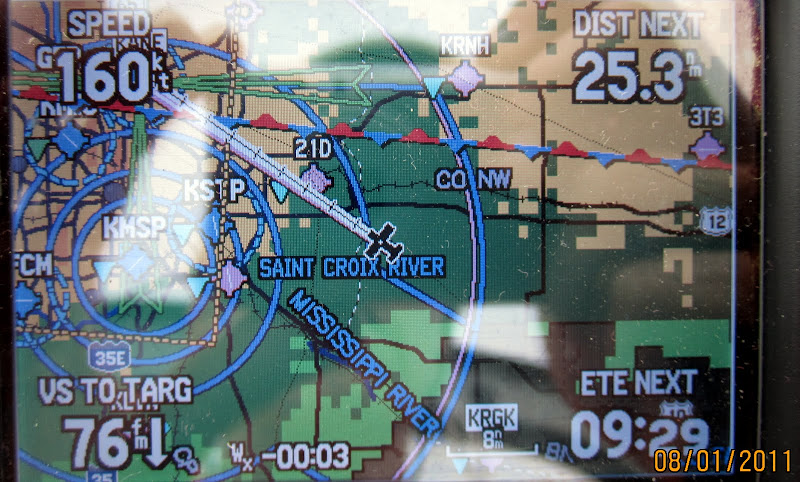
A couple miles from 21D and still no rain. Could I possibility make a safe trip to Anoka County (KANE)? I tune in that ATIS and things sounded very do-able. Light wind, light rain, decent visibility. As I reached Lake Elmo, a very light rain started (in what was reported as a yellow area). I called the Anoka Tower and the lonely controller confirmed that the rain was light, winds trivial, and visibility decent. I told him that I would try to come in if the weather remained good.
On the way in, I actually flew through a small patch of area recorded as orange, but I would only call it a steady "soaking" rain. No bumps. No lightening. No issues. The landing was a non-issue.
I found the experience highly interesting and useful. My path always had excellent retreat lines behind me (because I had basically flown from airport to airport). I have once previously flown into an area that turned yellow on me and I didn't like it at all. But, I've learned that light green, dark green, and yellow don't represent consistent conditions. In the humid south Texas, green seems to rarely mean actual rain. Seems the same was true yesterday for Minnesota. Yesterday was a great example of how going out in a strategic manner to find out what the weather data are really telling you, and ensuring excellent escape routes, can get you places that a review of a computer screeen would never have supported.
As I flew, I entered the light green area. No rain and good visibility. Okay, I've seen this before. As I approached KRGK, I listened to the AWOS at Lake Elmo (21D). No rain reported despite dark green. Since Lake Elmo would be much closer for Paul to pick me up, I decided to change course for Lake Elmo. The path to Red Wing remained clear as a potential retreat.
A couple miles from 21D and still no rain. Could I possibility make a safe trip to Anoka County (KANE)? I tune in that ATIS and things sounded very do-able. Light wind, light rain, decent visibility. As I reached Lake Elmo, a very light rain started (in what was reported as a yellow area). I called the Anoka Tower and the lonely controller confirmed that the rain was light, winds trivial, and visibility decent. I told him that I would try to come in if the weather remained good.
On the way in, I actually flew through a small patch of area recorded as orange, but I would only call it a steady "soaking" rain. No bumps. No lightening. No issues. The landing was a non-issue.
I found the experience highly interesting and useful. My path always had excellent retreat lines behind me (because I had basically flown from airport to airport). I have once previously flown into an area that turned yellow on me and I didn't like it at all. But, I've learned that light green, dark green, and yellow don't represent consistent conditions. In the humid south Texas, green seems to rarely mean actual rain. Seems the same was true yesterday for Minnesota. Yesterday was a great example of how going out in a strategic manner to find out what the weather data are really telling you, and ensuring excellent escape routes, can get you places that a review of a computer screeen would never have supported.
Last edited:
")

