
Van's Air Force
You are using an out of date browser. It may not display this or other websites correctly.
You should upgrade or use an alternative browser.
You should upgrade or use an alternative browser.
Help with another failed PAPR report
- Thread starter lndwarrior
- Start date

Longez
Well Known Member
These NIC/NACv/NACp errors are normally caused by poor GPS data when there are no Baro Alt errors, and you no longer seem to have those.I solved the problem with the lack of altitude info. on the previous report, but still failed again today. I seem to be close to passing on this one.
Any suggestions as to what I should try next?
TIA
Since the errors only occurred ~5% of the time on your 51 minute flight, it is probably not a software or installation error.
What we don't know from this data is whether the 5% failure was all at once (e.g. at the start of the flight before you had a good 3D Diff GPS fix) or sprinkled throughout the flight as would happen from maneuvering flight (causing antenna performance issues) or COM radio transmissions interfering with GPS reception and causing occasional low fix integrity.
The good folks from the FAA that provide these reports can also provide .kmz files that can be loaded into Google Earth which will show you, second-by-second, where along the flight your ADS-B output was non-compliant. You would have to specifically request this.
What I would do next would be to make another flight where you make sure and don't take off until the GPS navigator providing GPS data to your ADS-B Out transponder has a full 3D Diff fix. Throughout the flight, I would monitor the GPS status page for that navigator and make sure it is maintaining that 3D Diff fix and not occasionally downgrading during COM transmissions.
Not sure what kind of GPS source you are using, but this is what the GPS status page looks like on the GNX 375 I am using for all IFR GPS navigation and ADS-B In/Out.

If you get a clean report on this flight, then the 5% failure on this last flight was probably the result of either taking off before the GPS had a good fix, or cycling power on the GPS during flight which would have also resulted in failures of this type a small percentage of the flight.
If you don't get a clean report on this flight, and don't see GPS fix momentary downgrading when using the COM radio, I would request the .kmz data for the last flight and see what you can learn in Google Earth.
Steve
Last edited:
GalinHdz
Well Known Member
Start with this before you do anything else and see what happens. This way you don't wind up chasing an equipment problem that might not exist.What I would do next would be to make another flight where you make sure and don't take off until the GPS navigator providing GPS data to your ADS-B Out transponder has a full 3D Diff fix.

I had similar issues with passing the PAPR so I called uAvionix and spoke to David Wagner, who is the Echo guru.
After some checking, he determined that although my airport was right next to a big city, the radar coverage was poor below 1500' and I was likely failing during the takeoff, pattern and landing portions of the flight. My failure rate was around 2.5% of the flight.
Anyway, my VSo was set at 51KIAS, for the RV8, and he suggested I increase that number to 62KIAS in order to give the plane time to get airborne before the Echo started reporting.
I did that and it passed the next PAPR.
Just a thought.
You have to be in rule airspace for 30 minutes. That is your issue. Your PAPR says Rule: 00:00:00
I believe that’s incorrect. The 30 minute in rule airspace requirement was only needed when the FAA was issuing rebates for ADS-B installs. A clean PAPR can be had without flying in rule airspace at all. For example, my flight yesterday was 1 hour 18 minutes with 17 seconds in rule airspace, yet it was clean (no red).
It is true, however, that the FAA wants us to fly in ADS-B covered airspace for 30 minutes, but ADS-B covered airspace is not the same as rule airspace.
If you have information to the contrary, please post it so we can all learn.
Last edited:
Longez
Well Known Member
I believe that’s incorrect. The 30 minute in rule airspace requirement was only needed when the FAA was issuing rebates for ADS-B installs. A clean PAPR can be had without flying in rule airspace at all. For example, my flight yesterday was 1 hour 18 minutes with 17 seconds in rule airspace, yet it was clean (no red).
It is true, however, that the FAA wants us to fly in ADS-B covered airspace for 30 minutes, but ADS-B covered airspace is not the same as rule airspace.
If you have information to the contrary, please post it so we can all learn.
That is correct SPX. The failures in this PAPR report had nothing to do with not flying in rule airspace. As you have said, flying in rule airspace is only a concern if you are trying to get a "pass" for a rebate payment.
Steve
rocketbob
Well Known Member
I believe that’s incorrect. The 30 minute in rule airspace requirement was only needed when the FAA was issuing rebates for ADS-B installs. A clean PAPR can be had without flying in rule airspace at all. For example, my flight yesterday was 1 hour 18 minutes with 17 seconds in rule airspace, yet it was clean (no red).
It is true, however, that the FAA wants us to fly in ADS-B covered airspace for 30 minutes, but ADS-B covered airspace is not the same as rule airspace.
If you have information to the contrary, please post it so we can all learn.
https://adsbperformance.faa.gov/PAPRRequest.aspx
"For best results, ADS-B validation flights should be conducted within published areas of FAA ADS-B Coverage. Flying near the surface or at the fringe of ADS-B coverage areas may negatively impact the metrics provided in your PAPR Report."
"Published areas of FAA ADS-B Coverage" = rule airspace.
The reason why the FAA required rule airspace flights for rebates is because of cases like this one. There is a much higher chance to get bad percentages at lower altitudes where radar coverage is not as good. You might get lucky at lower altitudes.
Flying in rule airspace will guarantee good ADS-B and radar coverage.
https://adsbperformance.faa.gov/PAPRRequest.aspx
"For best results, ADS-B validation flights should be conducted within published areas of FAA ADS-B Coverage. Flying near the surface or at the fringe of ADS-B coverage areas may negatively impact the metrics provided in your PAPR Report."
"Published areas of FAA ADS-B Coverage" = rule airspace.
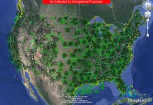
I disagree that Published areas of FAA ADS-B Coverage" = rule airspace. The image attached shows ADS-B coverage as of 2020. As you can see, there's a whole lot of ADS-B coverage than there is rule airspace.
Flying in rule airspace will guarantee good ADS-B and radar coverage.
It will guarantee good ADS-B coverage, but not necessarily radar coverage. Reference parts of Alaska that have no radar coverage, but great ADS-B coverage.
Sorry to get stuck on this, but I don't want to see people flying to "rule airspace" when their local airport is within perfect ADS-B coverage.
Attachments
rocketbob
Well Known Member
Sorry to get stuck on this, but I don't want to see people flying to "rule airspace" when their local airport is within perfect ADS-B coverage.
I've done three ESG installs and three Tailbeacon installs in 2020. In every case we flew in rule airspace above class C airspace. No failed PAPR reports.

