What's new
Van's Air Force

Don't miss anything! Register now for full access to the definitive RV support community.

Garmin GHA 15 Height Advisor - New Product Announcement

g3xpert

Well Known Member
Advertiser
Good Morning VAF!

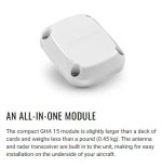
Garmin is pleased to announce the GHA 15, a small and lightweight height advisor that uses radar technology to provide height above ground level (AGL) information on G3X Touch flight displays for experimental aircraft.

AGL readouts are shown on the G3X Touch display and drawn on the altitude tape or gauge at altitudes as high as 500 feet AGL. Using the readings provided by GHA 15, G3X Touch flight displays can also provide AGL audio callouts via their audio output to help keep the pilot’s eyes looking outside the cockpit.

gha1511-L.png


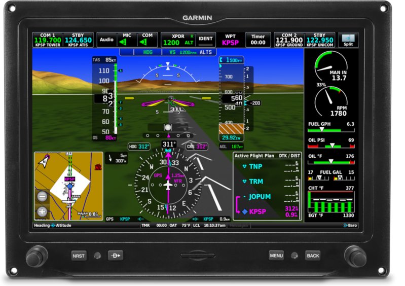
Beginning at 300 feet, the pilot will hear audible AGL altitude callouts at select intervals down to 1-foot AGL. The pilot can configure the callouts to start and stop at specified altitudes. This is helpful for landings in unique areas where limited barometric altimeter setting information is available – such as backcountry flying.

The single module integrates all electronics into one compact unit that attaches to the bottom of the aircraft. Weighing less than one pound, the GHA 15 requires minimal space and modification for installation on aircraft.

This cost-effective, easy-to-install solution for experimental and light sport aircraft is available to order now and expected to start shipping in mid-August. A new revision of the G3X Touch Installation Manual, Revision AT, will be posted to our website later today that will include all relevant installation information for this LRU.

Please let us know if any questions come up!

Thanks,

Justin
 
Last edited:
GHA15 query

Nice product!

Looking forward to seeing mounting requirements etc, was looking at another product on the market, however the G3X integration looks much better, do we need a firmware update on the G3X touch to run this or current v9.22 support the new LRU?
 
Software Update

Nice product!

Looking forward to seeing mounting requirements etc, was looking at another product on the market, however the G3X integration looks much better, do we need a firmware update on the G3X touch to run this or current v9.22 support the new LRU?

Software support for the GHA 15 will be provided with GDU v9.30+, which will be released in August of this year.

Thanks,

Justin
 
The G3X has had an AGL readout available for the configurable data fields at the top of the screen for a while now, driven by GPS I assume.

I'd love to hear Garmin's thoughts on how much more accurate the GHA 15 is over the legacy G3X AGL readout.
 
Altitude Accuracy

The G3X has had an AGL readout available for the configurable data fields at the top of the screen for a while now, driven by GPS I assume.

I'd love to hear Garmin's thoughts on how much more accurate the GHA 15 is over the legacy G3X AGL readout.

Great question!

Due to the fact that the GHA 15 directly measures the distance from the aircraft to the ground using radar, it is able to provide AGL data accurate to +/- 1.5 feet from 3-100 feet AGL and +/- 2% from 100 - 500 feet AGL.

GPS-derived height is affected by a number of factors including signal reception, satellite geometry, and database resolution. That is why the GPS-derived AGL data field you are used to seeing provides lower precision, and its data is removed entirely (dashed out) at low altitude. Meanwhile, an installation with a functioning GHA 15 can have an AGL data field that provides the most accurate data from both radar and GPS all the way to the ground.

Thanks,

Justin
 
New Worlds

So having this accurate data in the cockpit, does it open up New Worlds for us G3X'ers to explore?

For Example, can we shoot an IFR approach to lower minimums with this extra data?
 
For Example, can we shoot an IFR approach to lower minimums with this extra data?

Since this is an uncertified device, I think the answer is no. However, unless they’ve changed the FARs, it’s actually possible to get a cat II (100’ minimums) authorization for a single engine plane without a radar altimeter. But it requires re-certification, iirc, every 6 months, of the pilot and the barometric altimeter, which is such a pain that very few do it.
Edit. I looked up the rules, and they’ve changed again. It’s now still doable but so painful that no part 91 pilot will bother.
 
Last edited:
I might have to install one just for the ‘cool’ factor, alt callouts on landing
50, 40, 30, 20, 10…. :D
 
Stall in Ground Effect & Radio Altimetry

A curious phenomenon is that airplanes stall at a lower angle of attack in ground effect than they do at altitude, with 2° to 4° difference commonly quoted.

So if the AOA system is calibrated in one environment (out of ground effect) and you fly it in a different environment (in ground effect), you'll get different results. For example, if you're flying down the runway at 10 feet to get to your desired touchdown point, or if your student bounces the landing and recovers at 10 feet, you could stall the airplane before the stall warning system gives you adequate notice.

There is a patent out there that biases the angle of attack based on radio altitude (in ground effect), but only biases AOA as much as 1.5°. Garmin might choose to use that patent after they do the flight testing.

I've not been able to find much written on AOA in ground effect, but there is one computational fluid dynamics paper that discusses the subject. An interesting takeaway from that paper is that in ground effect, it's not just AOA that matters, it also matters how you got to that AOA. (!)

I'll be discussing this and other equally interesting and obscure AOA phenomenon in my Oshkosh forum at 10 on Monday in the NAFI tent. The title is, "AOA: Setting Reasonable Expectations." The data supports conclusions different from what is commonly advocated...
 
I might have to install one just for the ‘cool’ factor, alt callouts on landing
50, 40, 30, 20, 10…. :D

I agree! Although for $2K it needs to be ‘really cool’.
I wonder, from those who have experience with radar altimeters, is the quoted 1.5’ accuracy really good enough to judge touchdown? I think my eyes are at least that good (or maybe not?).
 
A curious phenomenon is that airplanes stall at a lower angle of attack in ground effect than they do at altitude, with 2° to 4° difference commonly quoted.

Ed, I’m very interested in this, but won’t be at OSH. Any chance your talk will be published (written or U-tube)?
I would guess that ground effect compressed air escapes upwards behind the wing, and helps to detach the flow? Just a guess.
 
Ed, I’m very interested in this, but won’t be at OSH. Any chance your talk will be published (written or U-tube)?
I would guess that ground effect compressed air escapes upwards behind the wing, and helps to detach the flow? Just a guess.

NAFI will have this presentation on their web site after the show, I believe. And there's enough interesting material that this might get published, or become a conference presentation.

And there's lots more to ground effect aerodynamics than just stall AOA, but I real quickly get in over my head.

Since the RV-9A accelerates so quickly on takeoff, and since I don't want to explore ground effect phenomena on landing, I've been experimenting with low power takeoffs in the RV-9A, 160 HP, constant speed prop. I've seen some interesting phenomena at liftoff down to 18.5" MP, but since I don't know what to look for and am not really sure what I saw, and since I haven't read much that might explain it, that won't be in the presentation. But you can guess what I'll be exploring when I get home, at least on calm days.

Thanks for your interest!

Ed
 
I agree! Although for $2K it needs to be ‘really cool’.
I wonder, from those who have experience with radar altimeters, is the quoted 1.5’ accuracy really good enough to judge touchdown? I think my eyes are at least that good (or maybe not?).

For the most part, its only really useful to experienced pilots to get an aural sense of the descent rate -- which can help if you go into a wacky airport (think sloping runway, excessively wide, etc). I think the real use though is for student pilots who are typically runway shy and will flare 10 feet up off the ground if you let them.

I have no doubt that a 24Ghz sensor can give accurate measurements -- especially over pavement and turf.. trees might be a different story though -- I doubt RF in this band can penetrate through leaves.. but seeing the top of the tree is safer than seeing the forest floor.

Using the Infineon chip as an example..the spec sheet shows about 250Mhz of bandwidth.. which is comparable to the bandwidth that the traditional radar altimeter uses in the 4Ghz band. As long as the software/firmware was programmed in a smart way, measurements down to centimeters can be had. Setting your sensor height above ground in the Config screens will be important.

The Garmin specs leave room for improvement though.. I can see them offering a GHA 17 (random number) which will work at up to 1000' with a slightly more powerful radar chip.

Everything you didn't want to know about radar altimeters: http://lea.hamradio.si/~s53mv/radalt/radalt.html

Garmin's FCC filings regarding the product: https://fccid.io/IPH-04099
 
Last edited:
For the most part, its only really useful to experienced pilots to get an aural sense of the descent rate -- which can help if you go into a wacky airport (think sloping runway, excessively wide, etc). I think the real use though is for student pilots who are typically runway shy and will flare 10 feet up off the ground if you let them.

Think floatplanes.
 
@Garmin

Is the AGL data logged to the SD card?

Separately, is the AGL data output on the "Text Out" data stream?

Thx!
 
might have to install one just for the ‘cool’ factor, alt callouts on landing
50, 40, 30, 20, 10…. :D

Not sure what you mean by 'cool' factor... but these callouts sure would remind me of work ;)
 
24Ghz Doesn't Penetrate Trees

We use 2Ghz, 5Ghz, 11Ghz, 24Ghz and 60Ghz in our business for microwave applications. The higher you go in the spectrum the less it penetrates foliage and is more prone to signal loss from rain fade, etc.

24Ghz won't penetrate foliage (penetration really starts falling off at 5Ghz). It has to be clear line of sight to the intended target. I also wonder about the accuracy in rain - at less than a couple hundred feet it may be ok but if it's heavy, it may be sketchy.

Not sure how/if it works for float plane, as in if it would sense the surface accurately.
 
Not sure how/if it works for float plane, as in if it would sense the surface accurately.

I would guess that since one of the Garmin engineers specifically called out float planes as a good use case, one could assume they have tested it out over water. Just an assumption though.
 
Last edited:
I would guess that since one of the Garmin engineers specifically called out float planes as a good use case, one could assume they have tested it out over water. Just an assumption though.

I once did a glassy water landing in a Husky, and the instructor told me to go around. Once we were back in the air, he asked me if I realized that I had landed.

Uh, no....

RA would have been nice at that point.
 
Part of the Fire Boss STC for aerial firefighting tankers requires just such a device as part of the amphibious float landing gear warning system. If the wheels are "down" and it senses a water surface it activates the warning system. When the wheels are up and it senses non-water surface it activates the warning system.
 
When first announced, I looked on the Garmin website, I saw $1,500. I looked today and saw $1,995. :eek:
 
Wonder if this potentially add some feature to Garmin’s Smart Glide, a stripped down version of Auto Land. Auto Land uses radar altimeter as one input. Of course still missing auto throttle and brakes. Maybe some sort of landing assist here the passenger just have to follow throttle instructions on the screen and then hit the brakes?
 
24Ghz

I have 24 Ghz radar altimeter, see link below.
It has been reliable below 700 ft GND.
It is very exact over RWY and water. I have seen no problem over terrain.
The only operational drawback is that it must be activated on GND before flight.
For some reason it is not reliable if activated when already airborne.
Connectors do not meet Garmin standards.
It is more expensive than the Garmin product.

https://www.wavenetradio.com/en/projects/dra-2421ga-2/

Good luck
 
Last edited:
When first announced, I looked on the Garmin website, I saw $1,500. I looked today and saw $1,995. :eek:

They must be following Lycoming's post covid pricing strategy - x% increase on odd numbered months and y% increase on even numbered months. :eek: Occasionally someone forgets to raise the price and we get two months in a row with the same low price. It's almost like a black friday deal. As you can tell, I am a bit jaded by what I have seen in pricing over the last year or two. A buddy bought cylinders recently and they were exactly double what I paid in 2019. Boy, do we need a recession to cool this off.
 
Last edited:
They must be following Lycoming's post covid pricing strategy - x% increase on odd numbered months and y% increase on even numbered months. :eek: Occasionally someone forgets to raise the price and we get two months in a row with the same low price. It's almost like a black friday deal. As you can tell, I am a bit jaded by what I have seen in pricing over the last year or two. A buddy bought cylinders recently and they were exactly double what I paid in 2019. Boy, do we need a recession to cool this off.

In the latest update for engine prices through Vans they actually lowered prices for regular engines and only increased thunderbolt prices. They have a 3 year order book on those so I think they are trying to steer more people to the regular models.
So it’s starting to cool off a little already. And they guarantee them until December!
 
Are there plans to let the GI275 display the radar altitude or won’t this work because the radar is experimental only? Any plans to release an experimental version of the GI275?
 
A curious phenomenon is that airplanes stall at a lower angle of attack in ground effect than they do at altitude, with 2° to 4° difference commonly quoted.

So if the AOA system is calibrated in one environment (out of ground effect) and you fly it in a different environment (in ground effect), you'll get different results. For example, if you're flying down the runway at 10 feet to get to your desired touchdown point, or if your student bounces the landing and recovers at 10 feet, you could stall the airplane before the stall warning system gives you adequate notice.

There is a patent out there that biases the angle of attack based on radio altitude (in ground effect), but only biases AOA as much as 1.5°. Garmin might choose to use that patent after they do the flight testing.

I've not been able to find much written on AOA in ground effect, but there is one computational fluid dynamics paper that discusses the subject. An interesting takeaway from that paper is that in ground effect, it's not just AOA that matters, it also matters how you got to that AOA. (!)

I'll be discussing this and other equally interesting and obscure AOA phenomenon in my Oshkosh forum at 10 on Monday in the NAFI tent. The title is, "AOA: Setting Reasonable Expectations." The data supports conclusions different from what is commonly advocated...

Interesting.

My take is that wing lift circulation which of course is distorted near the ground will change the lift slope, but the AOA indicator which measures the velocity vector will be predictive even though the wing is at a lower geometric angle.
In other words, the local angle of attack will be higher than its geometric angle indicates due to ground effect, but the AOA device will still give the proper output since it is driven by the same thing that determines lift and stall, the local angle of attack.


BTW, your example brought back images of my Part 141 days when a student bounced, added stick making it worse and we'er hanging 10 feet above the runway. Get the nose down, add a little power, don't bend the boss's airplanes.

Be well,
Ron
 
GI275 radar altitude

As I understand it, the GI275 works with G3X over Can bus and RS232.
The G3X and the GHA15 communicates via Can bus.
The GI275 can display radar altitude from the GRA55 via ARINC 429.
So the GI275 should be able to display radar altitude from the GRA55
or the GHA15. A G3X system can have a G5 OR a GI275. (not both).

Good luck
 
Last edited:
Quickly reading through the posts, and I don't think anyone mentioned the VAF advertiser Engine Bridge. (See front page left side.) Does this option do the same at less of a cost? I not researching for this product, just noticed it and am now curious about the differences.

https://www.enginebridge.com/product/landing-height-controller-copy/

The engine bridge product appears to be a LiDAR base system using the Garmin LiDAR sensor.

This new Garmin offering uses radar.
 
Last edited:
The engine bridge product appears to be a LiDAR base system using the Garmin LiDAR sensor.

This new Garmin offering uses radar.

For pure integration with a G3X I don't think you can beat the GHA15, its on the CAN bus, all you need is a CAN H/L and a DC supply and you are away, no scruffy audio inputs and or audio panel to worry about. Once the data is on the CAN bus is so much more flexible what you can do with it. Apart from the whole LiDAR vs RADAR comparison.
 
For pure integration with a G3X I don't think you can beat the GHA15, its on the CAN bus, all you need is a CAN H/L and a DC supply and you are away, no scruffy audio inputs and or audio panel to worry about. Once the data is on the CAN bus is so much more flexible what you can do with it. Apart from the whole LiDAR vs RADAR comparison.

I agree and extra characters!
 
As I understand it, the GI275 works with G3X over Can bus and RS232.
The G3X and the GHA15 communicates via Can bus.
The GI275 can display radar altitude from the GRA55 via ARINC 429.
So the GI275 should be able to display radar altitude from the GRA55
or the GHA15. A G3X system can have a G5 OR a GI275. (not both).

Good luck

Yes, technically they should be able to 'talk'. Just wonder if a certified instrument is permitted to display sensor inputs from a non-certified 'advisor' instrument. Common sense says it's up to the installer but this is aviation lol.
 
Received today

Once I get this installed, I'll sell my original Engine Bridge LIDAR unit (their earlier experimental-only version). I've been completely happy with this as an audio-only device, but I like the tighter integration of the GHA into the G3X system. And I'm dreaming of that Garmin autothrottle for my lycosaurus to give me Autoland in the RV! :)

One thing I didn't catch when I looked at the manual before: this thing uses a circular 22-pin plug. That connector uses a different pin which requires the DMC K40 positioner. I don't think I want to drop $500 for the DMC + positioner, so I will be outsourcing the construction of a harness pigtail that I can tap into my existing canbus as it heads under the seats & out to the roll servo.
 
What ??

I looked at this at OSH and the only wiring (I thought I saw) was power, ground and can bus. I even asked the Garmin rep if that was it? Obviously don't have one but really a 22-pin connection??
 

Attachments

  • Screenshot 2023-08-10 204349.jpg
    Screenshot 2023-08-10 204349.jpg
    29.4 KB · Views: 23
Last edited:
Is uses power, CAN bus and a USB connection for diagnostics (9 pins). The circular connector was likely the most practical option for installation since it only needs a round hole in your fuselage. Also better sealed than a sub-d. This sensor sits at the lowest point of your fuse so any spilled liquid would find the connector easily.
 
Is there software support for it yet? In post #3, Garmin said support for the GHA 15 will be provided with GDU v9.30+, which will be released in August of this year. Looks like they are still at v9.22.
 
22 pins, at most 9 are needed. The rest are either Reserved or N/C. As someone else stated, only 4 are needed in most installs - power, ground, can hi, and can lo. The other 5 are for a can term & an optional USB receptacle.

If you are ordering one of these & don't have the right crimper / positioner for these pins, you should consider ordering a custom pigtail from your Garmin dealer - Stein, etc.

Mounting requires a 1.5" hole in the bottom of your fuselage, plus 4 holes for mounting screws.
 
Once I get this installed, I'll sell my original Engine Bridge LIDAR unit (their earlier experimental-only version). I've been completely happy with this as an audio-only device, but I like the tighter integration of the GHA into the G3X system. And I'm dreaming of that Garmin autothrottle for my lycosaurus to give me Autoland in the RV! :)

One thing I didn't catch when I looked at the manual before: this thing uses a circular 22-pin plug. That connector uses a different pin which requires the DMC K40 positioner. I don't think I want to drop $500 for the DMC + positioner, so I will be outsourcing the construction of a harness pigtail that I can tap into my existing canbus as it heads under the seats & out to the roll servo.

I got mine yesterday and was looking at the connector and pins. Like you, I don't have the K40 positioner so I will just use my cheap Steinair crimper without the positioner. I added in the USB port so a few more wires for me.
 
I just wired mine up. I have an assortment of positioners for my Daniels crimper and chose one that was a bit too deep. I inserted a high density pin in the barrel and cut it to length to put the crimp area in the proper position. After crimping, removed cut pin and placed in next barrel. Though there is a good chance the USB option will never get used, I decided to add it now just in case.
 
from Garmin specs:
Performance Specifications
Altitude Accuracy: +/- 1.5 ft (3-100 ft AGL), +/- 2% (>100 - 500 ft AGL)
Altitude Range: 0 - 500 ft AGL
Horizontal Velocity: 0 - 100 knots maximum
Vertical Velocity: 20 ft/sec maximum (up to 100 ft AGL), 25 ft/sec maximum (above 100ft AGL)
Pitch Angle: +/- 20° maximum
Roll Angle: +/- 20° maximum

This max speed might affect some of us.

I'm normally much slower than 100KT when less than 500 AGL (most likely on final), so I don't see it affecting me personally, but YMMV.
 
I'm normally much slower than 100KT when less than 500 AGL (most likely on final), so I don't see it affecting me personally, but YMMV.

I’d bet Garmin’s lawyers added the speed limit to protect themselves from individuals who use this new device to make high speed, very low passes.
 
For those that did the install already.
How did you ground the shield of the CAN bus cable?
Not obvious to me with that fancy connector.
 
For those that did the install already.
How did you ground the shield of the CAN bus cable?
Not obvious to me with that fancy connector.

The last center pin, i believe is #22 is grounded to unit itself. That is where I attached the shield grounds.
 
Back
Top