

rightrudder
Well Known Member
Had a great flight this morning. Made the 1-hour drive to the airport in 45 minutes (the benefit of a 6 a.m. start to beat the bulk of commuters), scarfed down McDonald's finest Sausage McMuffin combo and was airborne over the Inland Empire by about 7:45. This was my third flight after finishing Phase 1, and I picked a great day...velvet smooth air, high cirrus clouds and only a hint of L.A. haze.
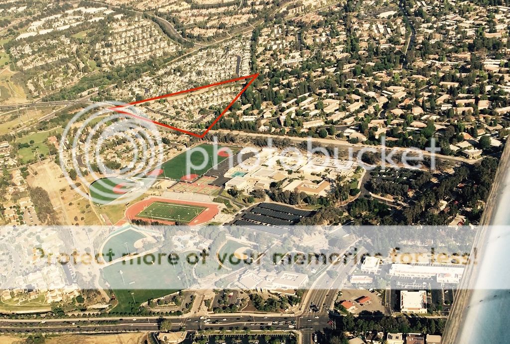
It's always fun the first time you fly over (or at least near) your house! I never knew that Laguna Hills High School had two big baseball diamonds, but there they are.
Laguna Beach and the Pacific are right over that hill, with Catalina Island in the distance (future destination!).

Then I headed south over the water, just outside Camp Pendleton's restricted airspace, then inland at Oceanside. This pic shows I-15, with the town of Rainbow at the base of the right hill and Murrieta/French Valley beyond the peaks.

Lake Elsinore. Lots of skydiving activity here, southeast of the lake.

For the first time coming back to Cable, my home airport, I approached it from the south. Without talking to ATC, this requires staying under Ontario's Class C shelf (2700 ft) and threading the needle between Brackett Field Class D, Chino Class D and the "To surface" portion of Ontario. Oh yeah, and way up high is a shelf of LAX's Class B, so it looks crazy on the TAC. A rat maze? It sounds a lot worse than it is. And very conveniently, there's a canal you can follow to prevent busting any airspace, so I was using that plus my GPS for no-worries navigation.
Better yet, the terrain rises in this direction, so it's very easy to get a nice stabilized airspeed and altitude early on, with plenty of AGL clearance. From the north, with descending terrain, you're always diving down to pattern altitude pretty close to the airport, making for a higher workload.
It's always fun the first time you fly over (or at least near) your house! I never knew that Laguna Hills High School had two big baseball diamonds, but there they are.

Laguna Beach and the Pacific are right over that hill, with Catalina Island in the distance (future destination!).

Then I headed south over the water, just outside Camp Pendleton's restricted airspace, then inland at Oceanside. This pic shows I-15, with the town of Rainbow at the base of the right hill and Murrieta/French Valley beyond the peaks.

Lake Elsinore. Lots of skydiving activity here, southeast of the lake.

For the first time coming back to Cable, my home airport, I approached it from the south. Without talking to ATC, this requires staying under Ontario's Class C shelf (2700 ft) and threading the needle between Brackett Field Class D, Chino Class D and the "To surface" portion of Ontario. Oh yeah, and way up high is a shelf of LAX's Class B, so it looks crazy on the TAC. A rat maze? It sounds a lot worse than it is. And very conveniently, there's a canal you can follow to prevent busting any airspace, so I was using that plus my GPS for no-worries navigation.
Better yet, the terrain rises in this direction, so it's very easy to get a nice stabilized airspeed and altitude early on, with plenty of AGL clearance. From the north, with descending terrain, you're always diving down to pattern altitude pretty close to the airport, making for a higher workload.
Last edited:


")

