I figured there would be threads on this already in existence, but I can't find any. I soon must make the decision about whether to go with Dynon HDX or Garmin G3X. Looks like the Dynon is about $2500 cheaper. Are there any compelling reasons to pay that much more for Garmin? I'd be interested in hearing how others reasoned out the decision. Are the map updates significantly different in price? Is one more capable than the other?
Jerre
Hello Jerre,
Could you help us understand where you are seeing the $2,500 difference?
From Van's website, there is only a $175 difference between the 2 base VFR systems, and even with fully loaded systems with autopilot and ADS-B, the difference is a few hundred, not $2,500. (Pricing checked for RV-12iS packages)
While we don't currently have any free database subscriptions, the equivalent of the free databases on the other system (and more) are only $49.99/yr ($4.17/mo).
These are the two U.S. database bundles available for G3X Touch systems. This is a system subscription that covers all of the G3X Touch displays (up to 4) in the system.
US Mini Database Bundle for G3X Touch Systems $49.99/yr ($4.17/mo)
Includes the following databases, updated as often as you like using an SD card in the display:
- US VFR Navigation Data (airports, runways, frequencies)
- Obstacles (e.g. towers - used to provide obstacle visual and aural alerting including obstacle depiction in synthetic vision)
- Terrain (used to render synthetic vision and provide terrain alerting)
- SafeTaxi (airport diagrams integrated into moving map that are displayed and zoomed automatically when you need them for taxi and landing)
US Database Bundle for G3X Touch Systems $149.99/yr ($12.50/mo)
Includes the following 7 databases, updated as often as you like using an SD card in the display:
- US Navigation Data (airports, intersections, navaids, runways, frequencies)
- Obstacles (e.g. towers - used to provide obstacle visual and aural alerting including obstacle depiction in synthetic vision)
- Terrain (used to render synthetic vision and provide terrain alerting)
- FliteCharts (Geo-referenced IFR approach plates, airport diagrams, arrival and departure procedures)
- SafeTaxi (airport diagrams integrated into moving map that are displayed and zoomed automatically when you need them for taxi and landing)
- Airport Directory (FBOs, runways, hours of operation, rental cars, etc)
- IFR/VFR Charts (VFR sectionals and IFR Hi/Lo charts, G3X Touch only)
For strictly VFR flying, there would be little reason to spend more than $49.99/yr for your G3X Touch system. This gives you navigation data for airports, frequencies, and runways, and terrain/obstacle data to keep all the terrain and obstacle alerting working to help you avoid those pesky towers. Additionally, it provides Garmin SafeTaxi, which automatically shows the airport runways and taxi-ways on the map to help you comply with taxi instructions on takeoff and landing.
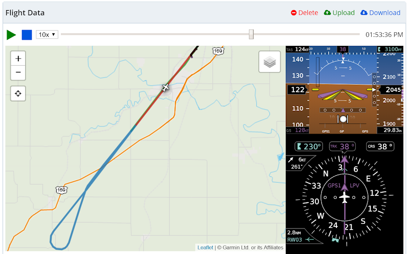
There is no need to contract with a 3rd party to obtain your databases, because Garmin sources all these databases and they are available from the same FlyGarmin portal that you will also use to upload your logged flights complete with flight data, autopilot modes, and engine data to your free FlyGarmin logbook. You can even re-play your flights and see everything that occurred including all autopilot modes and approach captures.
Everything about the Garmin system is high quality, professional, and Garmin designed/manufactured. We don't need to source navigators, audio panels, transponders, radios, and ADS-B transmitter/receivers from 3rd parties and put our name on them because we have the most complete product line in this industry.
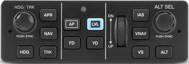
Customers purchasing G3X Touch systems for both certified and EAB aircraft often comment on how much they appreciate the high quality and ergonomics of the Garmin GMC 307/507 autopilot control panel. Everything needed to control the most powerful autopilot in the industry is all located in one area with high quality buttons and knobs.
Thanks,
Steve