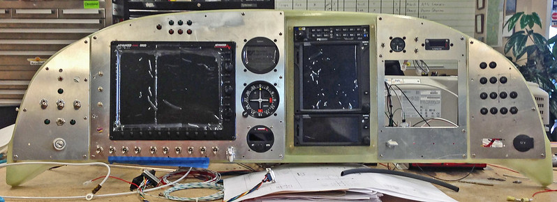
OK, so I am almost done with my wings and have been spending a little too much time at work researching EFIS feature and pricing changes and updating my ?spreadsheet? of choices when all of a sudden, none of the info on my spreadsheet matched what Advanced Flight had listed on their Price List. I started to look at it and noticed the prices on all of the 5500 Series EFISs had dropped a few hundred bucks, and then I noticed the price of the Autopilot dropped a GRAND, that?s no chump change. Getting gitty about what I noticed, I realized they also dropped their pricing a couple hundred bucks on their EMS add-on, their AHARS, AOA A and B kits and the list goes on. The total dropped the price of a complete 2 Screen system a little over 3 grand!!  I always drool over the RV10?s out there sporting the full AFS decks and their capabilities as well as their convenient included extras from the user checklists, weight & balance page, and maintenance page. Their pricing has always been a little too far off for my reach (Building Dave Ramsey Style), but now instead of the ?Big G? angel on one shoulder fighting with the GRT angel on the other shoulder; Advanced Flight just threw the ?Big G? off and jumped in the fight. Whatever am I supposed to do?
I am sure Rob Hickman is going to jump in here eventually and sort everything out or begin his own post announcing the new lower prices, but I just couldn?t let this go.
I always drool over the RV10?s out there sporting the full AFS decks and their capabilities as well as their convenient included extras from the user checklists, weight & balance page, and maintenance page. Their pricing has always been a little too far off for my reach (Building Dave Ramsey Style), but now instead of the ?Big G? angel on one shoulder fighting with the GRT angel on the other shoulder; Advanced Flight just threw the ?Big G? off and jumped in the fight. Whatever am I supposed to do?I am sure Rob Hickman is going to jump in here eventually and sort everything out or begin his own post announcing the new lower prices, but I just couldn?t let this go.