FlyinTiger
Well Known Member
Traveling by RV is a fantastic way to get around the country. For any destination this side of the Mississippi from SC I can easily beat total time to fly in a commercial airliner.
My daughter offered to accompany me on a family visit to Danville, KY. We loaded up her duffel bag and my back pack into the baggage compartment. With my "go bag" it was pretty much maxed out. Weighing the bags before we left the house prevented having to disappoint my daughter by having to leave something behind.
I planned a few days before and had a back up plan to drive if the weather didn't pan out. It would be an 8 hour drive if I include a lunch and fueling stops.
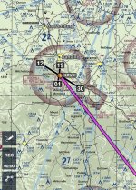
Flying the RV-7 would save a ton of hours and allow me to enjoy my magic carpet while performing a needed trip to see family. I needed the weather to cooperate for both sides of the mountains and at each airport (NOTAMS, TFRs, winds, rain, etc). It ended up being a little windy on my way up to Kentucky so I knew our ground speed would suffer a little. Cross winds were forecasted to be less than 20 knots in KY and Danville has a couple of runways to choose from, so it was still a go. I was current and proficient in cross wind landings. One consideration was that my RV-7 would be closer to the aft CG limit than I've flown it on a regular basis. Cross winds and aft CG is a combo worth considering as a challenge.
I use ForeFlight and have two devices that can display my planning info. An iPad Mini goes into the fan cooled mount on the panel and I have a smart phone that also runs ForeFlight with the same information available. I also have a couple of charts in a reachable side pocket in the baggage compartment. Even if the paper charts are a bit out of date they would still get me where I'm going if both electronic devices became unusable for some reason. I look over the route ahead of time, read the AFD info for my destination and nearby airports. I compare fuel prices at my destination and the cost of stopping somewhere cheaper along the way. Most of the time the cost of stopping to get fuel somewhere besides my destination to save 10 cents, or even 20 cents a gallon isn't worth it.
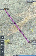
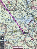
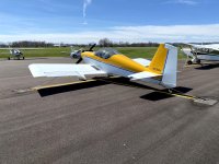
Taking off from SC45, Gilbert Airpark in Gilbert, SC with full tanks in my RV-7 I was limited by the weather. Winds favored cruising lower than the cloud ceiling at 4500 feet on my North West route while over the flat lands. As we neared the mountains we managed to get around a few clouds, staying below them but sufficiently above the Appalatian Mountain peaks. We went around the highest peaks by going a little South of our direct route to stay above the mountain wave turbulence. We were seeing about 150 knots ground speed consistently while heading North West into the wind toward KY. What a treat.
Keeping emergency airports within gliding distance is my practice as I fly over mountainous areas in a single engine airplane whether it be the Appalacians or the Rockies. It isn't always possible, but minimizing the time I spend outside the safety of being able to reach and airport is a goal.
My daughter took on the task of listening to a nearby airport's weather info and updating the altimeter setting and then the CTAF for that airport up. Looking ahead a little we planned to switch tanks at 30 minutes in, right before crossing the mountains, and then after crossing, but always near enough to an airport that we could perform a forced landing if the fuel valve were to fail in some way that caused the engine to quit. With my daughter on board I don't take many chances, it might seem silly, but where I can eliminate risk, I do, so the fact that flying a single engine aircraft over mountains is less than 100% risk free.
The bottom line is that the trip was successful. I got to enjoy a quick trip to KY so we could spend more time with family than driving there and my daughter was there with me, enjoying some Dad-time.
My daughter offered to accompany me on a family visit to Danville, KY. We loaded up her duffel bag and my back pack into the baggage compartment. With my "go bag" it was pretty much maxed out. Weighing the bags before we left the house prevented having to disappoint my daughter by having to leave something behind.
I planned a few days before and had a back up plan to drive if the weather didn't pan out. It would be an 8 hour drive if I include a lunch and fueling stops.
Flying the RV-7 would save a ton of hours and allow me to enjoy my magic carpet while performing a needed trip to see family. I needed the weather to cooperate for both sides of the mountains and at each airport (NOTAMS, TFRs, winds, rain, etc). It ended up being a little windy on my way up to Kentucky so I knew our ground speed would suffer a little. Cross winds were forecasted to be less than 20 knots in KY and Danville has a couple of runways to choose from, so it was still a go. I was current and proficient in cross wind landings. One consideration was that my RV-7 would be closer to the aft CG limit than I've flown it on a regular basis. Cross winds and aft CG is a combo worth considering as a challenge.
I use ForeFlight and have two devices that can display my planning info. An iPad Mini goes into the fan cooled mount on the panel and I have a smart phone that also runs ForeFlight with the same information available. I also have a couple of charts in a reachable side pocket in the baggage compartment. Even if the paper charts are a bit out of date they would still get me where I'm going if both electronic devices became unusable for some reason. I look over the route ahead of time, read the AFD info for my destination and nearby airports. I compare fuel prices at my destination and the cost of stopping somewhere cheaper along the way. Most of the time the cost of stopping to get fuel somewhere besides my destination to save 10 cents, or even 20 cents a gallon isn't worth it.
Taking off from SC45, Gilbert Airpark in Gilbert, SC with full tanks in my RV-7 I was limited by the weather. Winds favored cruising lower than the cloud ceiling at 4500 feet on my North West route while over the flat lands. As we neared the mountains we managed to get around a few clouds, staying below them but sufficiently above the Appalatian Mountain peaks. We went around the highest peaks by going a little South of our direct route to stay above the mountain wave turbulence. We were seeing about 150 knots ground speed consistently while heading North West into the wind toward KY. What a treat.
Keeping emergency airports within gliding distance is my practice as I fly over mountainous areas in a single engine airplane whether it be the Appalacians or the Rockies. It isn't always possible, but minimizing the time I spend outside the safety of being able to reach and airport is a goal.
My daughter took on the task of listening to a nearby airport's weather info and updating the altimeter setting and then the CTAF for that airport up. Looking ahead a little we planned to switch tanks at 30 minutes in, right before crossing the mountains, and then after crossing, but always near enough to an airport that we could perform a forced landing if the fuel valve were to fail in some way that caused the engine to quit. With my daughter on board I don't take many chances, it might seem silly, but where I can eliminate risk, I do, so the fact that flying a single engine aircraft over mountains is less than 100% risk free.
The bottom line is that the trip was successful. I got to enjoy a quick trip to KY so we could spend more time with family than driving there and my daughter was there with me, enjoying some Dad-time.