What's new
Van's Air Force

Don't miss anything! Register now for full access to the definitive RV support community.

Bubba makes his first trip to the big city (Los Angeles)

Ron Lee

Well Known Member
Planned flight path was 00V - KSEZ - P52 - KBNG - KCMP - KHHR

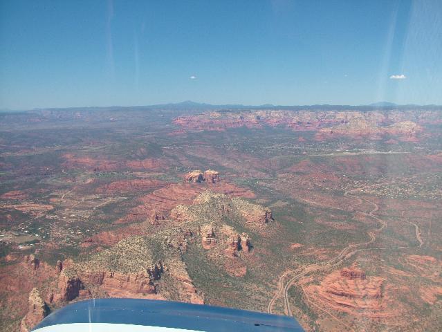
Altitude 16,500' using flight following. Fuel stop was P52 but that so close to Sedona that I had to check it out

Sedona1Small.jpg


I spotted Banning Pass over 130 nm away but did not know what it was (first time here). Around the time of overflying Banning Pass I was asked for my route and I mentioned BNG to CMP to HHR and that I was new here.

No problems other than having to change frequencies seven or so times before I was handed off to the HHR tower.

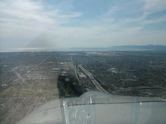
This is the view of HHR on final with LAX a few miles to the northwest (above the nose and a bit right). I was to remain above 1500' MSL until I crossed a certain expressway. I was over one that went east-west and asked if that was it. Nope...one ahead. After returning home I checked and the north-south one was 110. May or may not have been the one mentioned.

HHR1Small.jpg


The trip back was even easier leaving HHR. I was given a frequency where I got Class B clearance and climb to enroute altitude (17,500'). Fuel stop was at St Johns (KSJN) where the fuel was about $2.77 USD a gallon. This is another place I had wanted to visit because of the fuel price. Friendly FBO and landing to take-off was right at 30 minutes.

With preplanning, advice from guys in the California forum and superior piloting, it was not a problem even though I was apprehensive about flying in the LA basin. Another expansion of my flying comfort zone. If I ever go back, it will be much less stressful unless I go on a weekend. I do not like VFR flight corridors and my path did basically use them.

I was asked about my cruising altitudes. The terrain in much of the west is less than hospitable. What may look semi smooth and level from several thousand feet often is not. Altitude gives me options. My groundspeed is typically 155 knots and I burn under seven GPH. I will have to check my consumption over the entire trip to get an average including climb and descent but i will wager that it is still below 7 GPH.

I just checked and assuming no math blunders I averaged 6.8 GPH for the entire trip. That includes climbing to 16,500' twice on the way out and 17,500' twice on the way back (the first one from sea level).
 
Last edited:
Congratulations on the trip

Flying into the LA basin really is a big deal. You seem quite bit south of Sedona but I do all of my flight planning via airways using VORs and pass directly overhead. Your second photo on final to Hawthorn brings back a lot of memories of driving from JPL to LAX via the 105 for project monthly management reviews in Denver and Boulder.

Bob Axsom
 
LA Basin is a classic workload situation

I fly from Tucson to Fullerton (just north of Long Beach) several times a year and I FULLY appreciate the anxiety attached to navigating under, over, and around all of that airspace.

With a GPS & user defined waypoints, it's possible. W/o a gps, I wouldn't dream of it. Now that my a/p is installed, it makes it a lot easier to handle the many hand offs and rapid fire dialogue from LA Ctr.

I download the charts from SKYVECTOR, save them to disk, encode remarks right into my color charts (such as altitude), and let the system guide me in. Fortunately, I'm getting used to the landmarks so if the a/p croaks, I can do it manually.

In June, the marine layer rolls in which adds (yet) another dimension to the workload. Basically, this old man waits for the perfect weather day and tells the grandkids when we're coming.

Barry
Tucson
 
Other than being hot, the visibility was very good. No marine layer which would have been a no-go for me.

Having the Terminal Area Chart was essential although other charts may do the same thing. I don't know that I could do it without a GPS next time which is why I have two working.

Bob, the pic of the Sedona area was one that looks OK as I was flying in there. I don't believe that I got a picture on final due to workload issues. It is a pretty area and I should spend a weekend there sometime. Probably not in the summer though.
 
Last edited:
It doesn't make a lot of difference in VMC

If you are not instrument rated and current that isn't a routine option. If under VFR you contact Palm Springs Approach (TRSA) they will give you a SOCAL Approach frequency to contact on the other side of Banning Pass. Whether you actually contact them or not is up to you but if you do contact them and tell them where you are going they will give you vectors and handdoffs similar to IFR operations. Once they are communicating with you they do not want to lose you in that airspace. As long as they know where you want to go they will try their best to assure that you get there. The difference is you still have the airspace avoidance responsibility unless they specifically send you there - if concerned ask (sometimes it is hard to find a break in the communication).

Bob Axsom
 
Good story Ron!

I had never done any flying in the LA basin until I met Louise, and we started taking trips out to her cabin at Big Bear, and then dropping down into LA and San Diego to visit her family. Having read about all that airspace in the past, and the potential for being squeezed between mountains and the marine layer, I was a bit concerned - but it is just like anything - a little trepidation of the unknown gives way to "oh, so THAT'S how it works!" after you've done it a few times.

If I was really worried about traffic and penetrating deep into the heart of the area at rush hour, I'd file IFR, and not worry about it. But when the weather is VFR, I have found that picking airports on the outskirts works pretty well. As for flight following, well...the first time we went in to Montgomery Field in San Diego, the weather was VFR< so I called SOCAL approach as we came over the mountains. Got a squawk, flight following, and all was good. Then just as we were coming up on Gillespie field, trying to stay under the Class B and above their airspace, SOCAL gave me the "RV 8PD, radar service terminated, squawk VFR" call, and dumped me into a sea of traffic. Fairly disappointing, that was.....:eek:

Paul
 
Funny how just a few months can make you comfortable with something like flying in LA!

I felt the same way as all of you do about three months ago, but I can confidently tell you - for all the nervous explorers - that there's nothin' to it. The answer is VFR flight following. At all times. Every time (unless you're filing IFR, which is even better).

If you can talk on the radio, twist the knobs on your transponder and know how to push the ident button, you're fully qualified to fly in LA.

Oh - and keep your eyes peeled for traffic.
 
You forgot one thing...

.....
If you can talk on the radio, twist the knobs on your transponder and know how to push the ident button, you're fully qualified to fly in LA.

Oh - and keep your eyes peeled for traffic.

....even with Flight Following you need to be able to accurately read a map and program/follow your GPS.

Talking to VFR Flight Following does not give permission to enter (bust?) the Class B airspace, and using the picture showing the HHR approach above, the LAX Class B airspace drops to the surface just about at the Freeway shown under the spinner. Not much tolerance there when the visibility is not as clear as in the picture....:(

And if Flight Following drops you to 2000 ft AGL, spotting things in the distance gets harder.
 
Gil, thanks again for the suggestions on routing. I gave the TAC back to the owner so I can't comment on how I would do it again. Perhaps the visual waypoints recommended or the same way I flew this time. At first I considered a straight in getting Class B clearance but elected to divert a bit south so I could stay higher.

I can't file IFR so I have to do things in the VFR world.

My previous flight in that area was not in the basin like on this trip and was documented in this write-up

http://tinyurl.com/dxn3ef
 
My back yard

I've been flying in SoCal my entire adult life and to this day ALWAYS have and use a current Los Angeles TCA chart. The scale makes it much easier in this complex environment. Although I don't use SoCal Approach very often, i do moniter the appropriate freq. That being said, Chino is on the fringe and most of the airports I frequent are also on the edge. I do avoid the belly of the beast unless necessary. Going into some of the busier airports like John Wayne and Long Beach where there is a lot of jet traffic SoCal Approach is almost a must. The others can be navigated to without any delays much easier. It can get frustrating being told by SoCal to call back in 5 minutes but if your unfamiliar, at least they won't let you go somewhere you shouldn't be. In the 35+ years flying around in the LA basin, the closest encounter (dangerous) I've had with another aircraft was in the center of the San Joaquin Valley (Hanford) where you would least expect it (of course on final at OSH you do expect it as they turn in from all directions :eek: ).
 
Last edited:
Back
Top