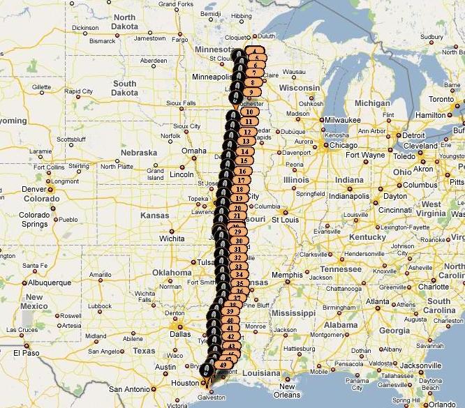
When I flew from Houston to Minneapolis on Sunday, into the teeth of 30 knot headwinds, I figured I’d have a nice ride home on Tuesday. But no good deed goes unpunished, since the high pressure area generating the northerly flow on the way up had shifted just far enough east to provide southerly flow and 30 knot headwinds for the return as well. Fortunately, the winds decreased with altitude (odd in the winter) so the higher I went, the less the effect would be. The forecast for weather was good - clear (and cold) skies down into southern Missouri, with broken to scattered clouds the rest of the way. I picked Neosho (EOS) as a refueling spot, slightly more than halfway home, a place I have landed before, with reasonable fuel prices. If I hit more headwinds, I had plenty of options in northern and central Missouri as well.
I was glad that I’d left the Valkyrie in a heated hangar for two nights, as it was ready to go for a morning departure, despite the cold temperatures. I launched off Anoka County airport as the clock ticked over 0800, and scooted around the east side of the Class B airspace, looking at old haunts and how the city had grown since I lived there in my youth. Sure enough, the southerly flow was there, with 35 knots of headwind down low. As soon as I cleared the Class B, I climbed up to 10.5 K, and was rewarded with virtually calm winds, and temperatures that weren’t so bad as on the trip up. The sun coming in to the bubble warmed my upper body as the standard one-hole heater kept my toes warm. Nevertheless, the thermal underwear under my flight suit was welcome!
The NEXRAD showed an interesting line of precipitation running east-west across the middle of Missouri - actually, all the way from Wichita in the west to east of St. Louis. Mostly green, it also had some yellow and a little orange embedded along my route. Squinting into the distance, I could see some high cloudiness, and wondered what this disturbance was all about. I hit the “animate” button on the 696, and saw that the line of precip was sliding east and dissipating in the west, so I decided that if it was still there in the hour it would take to get to it’s location, I could deviate into Kansas if needed. I am always worried about icing in any precipitation in the winter, so I kept an eye on the OAT, which seemed to be rising. As it turned out, no deviation was required, although I did dip down a thousand feet to duck under some high cloud remnants, and it was clearly dark and still precipitating to the east as I passed through. It was time to begin a descent into EOS anyway, so I dialed in a good rate, and followed the Flight Director to give it some more test time. It really gave a nice steady descent rate, something that I always have to do by eye and experience in general. The FD gave me a precise pitch angle to aim for, and that worked out every well.
It became clear on the way down to EOS that the forecast of scattered to broken layers down low were overly optimistic. Overcast with holes was more what I was seeing, with solid overcast to the south, topping out about 6,000’. I had no trouble making a visual descent into EOS for fuel, but with ceiling at about 2500’ AGL there and to the south, I took a closer look at what was happening at reporting stations along the rest of the route. Pretty much everywhere I was seeing the overcast about 2500, with some stations reporting breaks. The problem in that part of the world (western Arkansas) is that there are numerous hills and ridges, some quite high. When all of the reporting stations (down in the valleys) report overcast at 2500, that means that the ridges are often times shrouded in low visibility clouds. I have played “VFR-Dodge-Mountain” south of Fort Smith many years ago, and say “no thanks!” to that option now - it is nerve-wracking enough to follow a highway at low altitudes through hills in a slow airplane - doing it at RV speeds is just not fun! So while I was waiting for the fuel tanker to fill up the self-serve tanks (bad timing on my arrival - they had just started!), I logged in to Weathermeister, checked the detailed forecasts, and filed IFR to home. I was just passed the southern edge of the icing Airmet from the system that was north and east of me, so I was comfortable with the climb through the clouds in the area. Light green precip was showing up along the early part of the route, but it looked like the kind that never reaches the ground, and temperatures had been several degrees above freezing at the altitudes of the tops.
This is the kind of IFR I like - good ceilings (and visibility) at both the departure and arrival ends, a chance to cruise above the tops knowing that you are in the system and have bailout options below, and equipment that gives you the option to quickly aim for an alternate and shoot an approach with clear guidance (to someplace you have never been) in case of emergency. The clouds at the Houston end were showing broken, with bases around 3,000’, so I figured that I wouldn’t even have to shoot an approach when I got there. I lifted off of EOS with full tanks, dialed in the Center frequency and checked in, looking for my IFR clearance to Houston (with VFR visibility and plenty of cloud and ground clearance if I needed to wait). But the controller came back immediately with an IFR squawk and my clearance “as filed”, and I pushed on up through the deck of clouds to see clear and sunny on top to the south! A couple of hours cruising at 11K, and I was ready for a descent through the large holes in the broken layer at my destination (T78, Liberty Texas, with cheap fuel on the east side of town. It’s always good to top off before ending up at our home airpark, since we don’t have fuel there). The winds were gusting out of the south, giving my feet a good work-out on landing, but I was back in the warm weather, and couldn’t wait to get home and peel off the thermals!
This is how I like to use the IFR capability of the RV - known good weather at both ends, XM weather in the cockpit to monitor conditions in real-time, and lots of extra fuel (in this case, 2:15 of reserves) to detour if required. The capability to shoot low approaches with advanced EFIS representations (HITS and Flight Directors) and redundant Nav systems is something I save as a level of margin - I don’t go into a flight planning to use it. And weighing off a VFR scud-run in hills and valleys against a boring high cruise above the clouds with the knowledge that if the clouds don’t clear at the destination, you are already set up for an approach? Priceless! (Well, I am sure that Stein can work up a price for you…..)
Paul
Last edited: