What's new
Van's Air Force

Don't miss anything! Register now for full access to the definitive RV support community.

Enhancements for aprs.fi site

Sam Buchanan

been here awhile
There have been some recent goodies added to the aprs.fi tracking site that we use. You can find these new options in the "Preferences" menu:

aprs-enhanced2.jpg


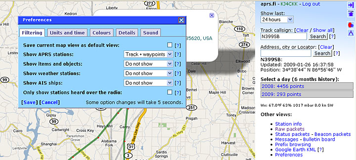
You can now customize the color of the track. I changed the track of N399SB from aqua to dark green so it would pop off the terrain map view better.

Another option is to set the units to "nautical". Now the speed will be displayed as knots instead of mph.

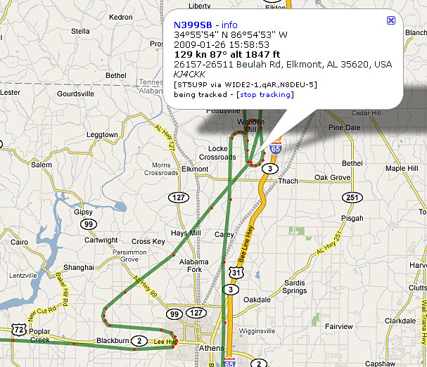
A really cool new feature is in the "Details" tab of the Preferences menu. We can now have the info bubble include a geocoded address of a particular beacon. This often provides a street (911) address of a beacon:

aprs-enhanced.jpg


Try clicking the icon with the horizontal arrow in the upper right corner of the map. It will expand the map to full screen width, really impressive if you don't need the menu visible.

APRS continues to evolve in ways that enhance our aviation use of the network. I enjoyed reading about Doug watching my recent flight--what he didn't notice was how there were three aircraft trackers in my area that were airborne the same afternoon. :)
 
Look at those sweet turns. There ought to be some sort of soothing music to go along with it!
 
Why more "dots" in the turns?

Why ARE there more "dots" in the turns? Going slower? Do you have any control over frequency of position reports?

That is one thing I do not like so much about SPOT. At 10 minute intervals you can cover a lot of territory so track is pretty spotty. I guess purpose is emergency location rather than tracking.

May have to get my HAM license after all these years. I never could get the code down 40 years ago when I tried. I don't think they even had the technician category back then?

Thanks Sam,
 
Why ARE there more "dots" in the turns? Going slower? Do you have any control over frequency of position reports?

That is one thing I do not like so much about SPOT. At 10 minute intervals you can cover a lot of territory so track is pretty spotty. I guess purpose is emergency location rather than tracking.

Modern APRS trackers include a feature called 'smart beaconing' - it simply sends more reports when you are in a turn. ;:D

You can control the frequency of reports, but except for turns reports more often than every minute are frowned upon (there is one shared frequency for all the trackers in an area and the protocol wasn't especially well designed)
 
Why ARE there more "dots" in the turns? Going slower? Do you have any control over frequency of position reports?

That is one thing I do not like so much about SPOT. At 10 minute intervals you can cover a lot of territory so track is pretty spotty. I guess purpose is emergency location rather than tracking.

May have to get my HAM license after all these years. I never could get the code down 40 years ago when I tried. I don't think they even had the technician category back then?

Thanks Sam,

Allen, here is a post that will explain SmartBeaconing:

http://www.vansairforce.com/community/showthread.php?t=28783

Go ahead and get the Tech license, easy to study and pass and no code. :)
 
Today I noticed the when mousing over a beacon, it shows you the digipeater and the igate that sent the packet. Thats pretty cool. No more poking around to see where the packets are going. Just hoover over a point.
 
So Mike during that trip over the water you are planning will be no digi/beacon ID experiments? Right?


Today I noticed the when mousing over a beacon, it shows you the digipeater and the igate that sent the packet. Thats pretty cool. No more poking around to see where the packets are going. Just hoover over a point.
 
Ill be transmitting.
Let the packets drop where they may.
Looking at the aprs map for key west, I dont see any igates for 100 miles.
Will be interesting to see how the distance works.
THere was a question about it on another thread.
 
Back
Top