Dear Oshkosh attendees,
as done last year, I am beginning to organize Show and Tell session where owners / builders of RV-10s invite other RV-10 builders / owners to come by at a certain time to ask questions and hear the build story. We had maybe 5 sessions with between 3 and 10 people showing up.
Last year was organized by a manually maintained Google Sheet. It was really hard to get position links into the sheet for on-site navigation to the parking position.
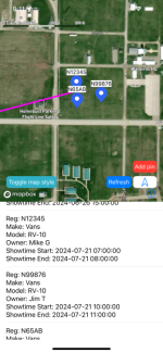
For this year, I wrote a little app called "PlaneTour" in the hope to get more sessions! Please sign up if you are flying to OSH with your RV-10 as soon as the app is online.

It's for iPhones/iPads but I am working on a web based form to suit other phone makes. If someone wants to quickly make an Android version, I can supply the json APIs of the backend. The map library is from MapBox which is also available for Android.

Right now it's in the queue at the Apple App Store. I'll post here once it's live.
The instructions are on the Wiki:
Martin
San Diego
as done last year, I am beginning to organize Show and Tell session where owners / builders of RV-10s invite other RV-10 builders / owners to come by at a certain time to ask questions and hear the build story. We had maybe 5 sessions with between 3 and 10 people showing up.
Last year was organized by a manually maintained Google Sheet. It was really hard to get position links into the sheet for on-site navigation to the parking position.
For this year, I wrote a little app called "PlaneTour" in the hope to get more sessions! Please sign up if you are flying to OSH with your RV-10 as soon as the app is online.

It's for iPhones/iPads but I am working on a web based form to suit other phone makes. If someone wants to quickly make an Android version, I can supply the json APIs of the backend. The map library is from MapBox which is also available for Android.

Right now it's in the queue at the Apple App Store. I'll post here once it's live.
The instructions are on the Wiki:
Martin
San Diego

