HFS
Well Known Member
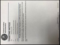
Got this from someone else, and as a privately owned (and licensed since 1949 (92CA)) airport operator I was interested to see that it will no longer be shown on VFR Sectionals after the November issue.
There may or may not be others of you out there this will affect - just thought I would bring it to your attention for your interest.
Thx - HFS
I apologize for the orientation of the pic - I tried (several times) to right it, but couldn't make it work - sorry.
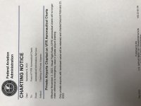
There may or may not be others of you out there this will affect - just thought I would bring it to your attention for your interest.
Thx - HFS
I apologize for the orientation of the pic - I tried (several times) to right it, but couldn't make it work - sorry.
")