SydneyACE

Member
How do you guys measure partial runway distances accurately?

Example: I was at a controlled airport recently and ground offered me Runway 30 at Alpha 2. (I was parked near where Alpha 2 intersects the runway, and I think he was trying to save me some taxi time.) By looking at the airport diagram I was able to make a quick guesstimate of the distance. The runway is 9,000ft total, and A2 was about 1/3 of the way from the end, so I quickly estimated about 6,000ft of usable runway from A2. The controller in this situation actually told me in his next transmission that I would have 5,700ft of runway.

It would also be handy to know exactly how much of a runway you're using when landing, if you get it stopped by "X" point...

Later I tried to use Foreflight to measure parts of different runways via the airport diagram. I couldn't come up with anything. It would be handy to be able to quickly and accurately measure parts of the runway. My best method as of now is to use a ruler and fancy scale conversions. Anyone else have a better method?

I think that every time I have been offered an intersection TO by a tower, they have told me the available runway length from that intersection. Even if they just offer it as an option, they provide the length. I am guessing their rule book tells them they must do this, as there is no real easy way for a pilot to do anything but guess.
 
Last edited:
I think that every time I have been offered an intersection TO by a tower, they have told me the available runway length from that intersection. Even if they just offer it as an option, they provide the length. I am guessing their rule book tells them they must do this, as there is no real easy way for a pilot to do anything but guess.

I think you're right, but it would be useful in other situations too.

Like, figuring out how much runway you used up during landing.
 
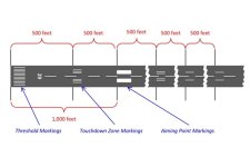
The runway aim point and touchdown points can help with the math. The Aim Points are approximately 1000ft from the approach end of the runway, and the touchdown points are 500ft apart.
 

Attachments

  • Runway.jpg
    Runway.jpg
    35.6 KB · Views: 287
Well... I think I got lost in the question.

If on the ground in your running airplane, you are limited (and I would ask if concerned). If sitting at your computer, Google Earth (ruler) is pretty great for such things.

If in the air, the runway markings already noted can help. In the backcountry, we overfly the runway at 60kts and count the seconds to get hundreds of feet.
 
With Foreflight on my iPad, the ruler tool is a quick and easy way to measure that distance. I know not everyone uses foreflight, but thats how i've done it in the past. If you have a EFIS, you may be able to use distance rings and positioning the map to make an estimate as well? There are probably some ways to utilize the technology we have available in our planes to get pretty close.
 
Standard center line stripes can help. They are 200' from start to start of next. IIRC it's 120' stripe and 80' space.
 
How do you guys measure partial runway distances accurately?

Later I tried to use Foreflight to measure parts of different runways via the airport diagram. I couldn't come up with anything.

From Foreflight:

Tip of the Week: Quickly measure distance on the map by holding down two fingers until the ruler appears. Slide your fingers to position the ruler where you want it.
 
Well... I think I got lost in the question.

If on the ground in your running airplane, you are limited (and I would ask if concerned). If sitting at your computer, Google Earth (ruler) is pretty great for such things.

If in the air, the runway markings already noted can help. In the backcountry, we overfly the runway at 60kts and count the seconds to get hundreds of feet.

Nice! The Google Earth Ruler is perfect! I hadn't messed with that before.

Also, the flyover at 60kts is a good idea, although probably not super accurate due to winds. I'll have to do a little research on that technique. Thank you.
 
From Foreflight:

Tip of the Week: Quickly measure distance on the map by holding down two fingers until the ruler appears. Slide your fingers to position the ruler where you want it.

I was trying to do it from the airport diagram page. I'll have to try it from the main map. I don't have my iPad with me at the moment. I didn't realize that the airport would show up in detail from the map page. I was assuming it wouldn't be precise enough for what I was trying to do. I'll mess with it when I get home.
Thank you.

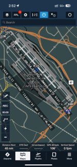
The Aeronautical layer effectively shows the airport diagram on top of whatever map layer you have (VFR, Aerial, etc.)

Heres a screenshot from my phone showing SJC and some random measurement with the ruler. This is just the Aeronautical map layer with nothing else selected.

IMG_5099.jpg
 
If in the air, the runway markings already noted can help. In the backcountry, we overfly the runway at 60kts and count the seconds to get hundreds of feet.
But these are RV's... Do it at 180kt and it's 300' per second. If you can count 6 Mississippi's you've got 1800' to land on, and your start and end points will be more accurate the lower you are... :)
 
How do you guys measure partial runway distances accurately?

Example: I was at a controlled airport recently and ground offered me Runway 30 at Alpha 2. (I was parked near where Alpha 2 intersects the runway, and I think he was trying to save me some taxi time.) By looking at the airport diagram I was able to make a quick guesstimate of the distance. The runway is 9,000ft total, and A2 was about 1/3 of the way from the end, so I quickly estimated about 6,000ft of usable runway from A2. The controller in this situation actually told me in his next transmission that I would have 5,700ft of runway.

It would also be handy to know exactly how much of a runway you're using when landing, if you get it stopped by "X" point...

Later I tried to use Foreflight to measure parts of different runways via the airport diagram. I couldn't come up with anything. It would be handy to be able to quickly and accurately measure parts of the runway. My best method as of now is to use a ruler and fancy scale conversions. Anyone else have a better method?
I use the Google earth measuring function, but to address the OP situation, can you just ask the tower what the takeoff distance remaining at whatever intersection they are offering? Seems that if they offer it, they should have an idea of runway remaining..
 
Every tower cab I've visited has an airport diagram marked with runway length remaining from every taxiway or runway intersection. Just ask the controllers.
 
Can't speak for USA tower controllers, but here up North, as a controller offering an intersection departure, it's mandatory to inform the pilot of the remaining runway distance. It's not if the request comes from the pilot.
 
Can't speak for USA tower controllers, but here up North, as a controller offering an intersection departure, it's mandatory to inform the pilot of the remaining runway distance. It's not if the request comes from the pilot.

I do recall a few times in GVA when the grass runway was closed the controller asking if I can accept an intersection departure with "only" 2000 meters remaining. I thought he was kidding, but perhaps it is a requirement.

Alas, the grass runway is now permanently closed. :(
 
If it’s a controlled airport, I just ask the tower. If its pre-flight planning or post-flight analysis - Google Earth is my go-to measuring tool…..
 
Landing runway length determination

But these are RV's... Do it at 180kt and it's 300' per second. If you can count 6 Mississippi's you've got 1800' to land on, and your start and end points will be more accurate the lower you are... :)

In the Cub, as I fly downwind at pattern altitude, the length of runway I can see between the lift struts is all I need to land or depart. I haven't determined what to measure that with in SuzieQ as I have not had a reason to yet. One width of the wing on downwind? I need to determine that sometime....:)
 
I guess my example of being offered a partial runway takeoff wasn't a great example as they did (and seemingly always do) tell you the distance.

I've been practicing for shorter fields and have been using landmarks along the runway to gauge landing distances. I'll aim for a certain spot on the runway for touchdown, then get stopped and see where I'm at in relation to taxiways, runway markings, or other landmarks next to the runway.

I did confirm that I can use the measuring tool on Foreflight to measure on the airport diagram from the map page. I did not know that the airport diagram would show up if I zoomed in far enough! That's awesome. I feel dumb, I never tried zooming in that far, and didn't assume the diagram even showed up there.

It's not perfect for using runway markings, as those don't show up on the airport diagrams. Fortunately, Google Earth works perfect for this since the satelite images show the markings.

Thanks again for all the helpful tips guys!
 
It's just far too easy to decline the offer unless in is striking obvious. Besides, you need to warm up and do cockpit checks, etc anyway...