grumman41

Active Member
I’m sure I’ll get roasted here as there is a lot of support for the AFS EFIS. My experience has been Honeywell, Collin’s , Garmin with several generations of each with smaller “GA” boxes thrown in for good measure.
First, I’m very glad my RV6 has EFIS of some type as the info makes it so much easier for x country trips which is my main use. I’ve read several articles by R Leffler and he has some solid advice concerning bouncing between internal flight plans, etc. Most of the AFS “architecture “ seems ok for VFR flying but lacks structure and clarity for weather flying. Garmin has a learning curve but is very intuitive for most pilots. I have a basic understanding of the internal flight plan but I’m still developing a safe, effective cockpit setup for weather flying. I welcome input on how you manage your avionics for weather flying.
GTN 650
Trutrack autopilot
5600 PFD
5600 MFD
Remote audio panel
Remote autopilot controls (not a fan for IFR flying)
I use an AFS 5400 as my primary EFIS plus an old .legacy 3500 for moving map. The 5400 is indeed VFR-only, as is true of any non-TSO'd navigators. In my case, I have an Avidyne IFD440 sending its data to both the 5400, the 3500, and the autopilot can be slaved to either the 5400 or the IFD440 (switched). Likewise, I can switch to either the 5400 or the IFD440 as my GPS navigational source. If find both to be intuitive, but generally prefer the IFD440 as its FMS is pretty intuitive (and legal for IFR).
 
I’m sure I’ll get roasted here as there is a lot of support for the AFS EFIS. My experience has been Honeywell, Collin’s , Garmin with several generations of each with smaller “GA” boxes thrown in for good measure.
First, I’m very glad my RV6 has EFIS of some type as the info makes it so much easier for x country trips which is my main use. I’ve read several articles by R Leffler and he has some solid advice concerning bouncing between internal flight plans, etc. Most of the AFS “architecture “ seems ok for VFR flying but lacks structure and clarity for weather flying. Garmin has a learning curve but is very intuitive for most pilots. I have a basic understanding of the internal flight plan but I’m still developing a safe, effective cockpit setup for weather flying. I welcome input on how you manage your avionics for weather flying.
GTN 650
Trutrack autopilot
5600 PFD
5600 MFD
Remote audio panel
Remote autopilot controls (not a fan for IFR flying)
I fly two AF5600T w/ upgraded CPU etc (similar to AF6000) (PFD/MFD) with ext knob panel & AP panel - driven by GTNxi, have an AdvFlt GPS puck antenna as a 2nd NAV source. It feels very similar (within reason) to the EFIS systems I flew in my career doing avionics design/development in a multitude of jet-A powered planes. Internal Flt plans are a back-up only capability.
 
Thanks for your input, I would agree that the internal flight plan is the part that i wouldnt do as a developer. Having to “sync” auto pilot to EFIS altitude is a bit strange also. I’ve never touched a GTN 650 prior but it’s been very easy even with approaches, departures, etc.
 
Thanks for your input, I would agree that the internal flight plan is the part that i wouldnt do as a developer. Having to “sync” auto pilot to EFIS altitude is a bit strange also. I’ve never touched a GTN 650 prior but it’s been very easy even with approaches, departures, etc.
I suspect the "sync" you speak of is due to your separate AP installation, The 5600T & s/w incorporate a very capable AP (just add servo's, and in my opinion the AP panel). I like to have the internal FP capability in case primary primary navigator goes TU or if copilot wants to play with something different while not affecting GTN Nav. Avionics have progressed rapidly (everybody's), your installation might benefit from a few changes if you're so inclined.
 
The way my panel is set up under SOURCE I have three options, gnav1, gps2 and intfp. I understand the concept of intfp for the AFS system, with one gps in my system (GTN650), would this be gps2? What is gnav1? Is this usually standard for all AFS installations?
 
The way my panel is set up under SOURCE I have three options, gnav1, gps2 and intfp. I understand the concept of intfp for the AFS system, with one gps in my system (GTN650), would this be gps2? What is gnav1? Is this usually standard for all AFS installations?
I suspect you have a backup Dynon GPS-250? If you don't you should so that the map works if you have an electrical failure.

Depending how many external Navigation devices are connected to the EFIS you could have the following options:

[GNAV1]
Selects a GPS Navigator (GPS+NAV) (IFD440, IFD540, IFD550, GTN650, GTN750)

[GNAV2] Selects second GPS Navigator (IFD440, IFD540, IFD550, GTN650, GTN750)

[GPS2] Selects attached GPS (Dynon GPS-250, Dynon GPS-2020, Garmin 696, Aera 760, …)

[NAV1] Selects attached NAV Radio (SL30, GNC255)

[INTFP] Selects CDI to follow the EFIS Internal Flight Plan. The EFIS will automatically decide which attached GPS to use for position data and will switch GPS sources if the active GPS signal is lost.

In most IFR installations you will have:

GNAV1- GTN650xi or IFD540 the main IFR navigator that has GPS and a NAV Radio sending the EFIS the flight plan
GPS2- Dynon GPS-250, This is a backup GPS that is powered by the EFIS backup battery
INTFP- Uses the internal EFIS flight plan feature.

When you select GNAV1 the EFIS should display and the CDI should follow the flight plan from the IFR navigator.
When you select INTFP the EFIS should display and the CDI should follow a flight plan that you have entered using the EFIS Flight Plan Menu.

In my RV-10 with an Avidyne IFD550, Garmin GTN650xi and Dynon GPS-250 I have the following options:

GNAV1- IFD550
GNAV2- GTN650xi
GPS3- GPS-250


In my case selecting GPS3 does not make sense since the Dynon GPS-250 does not have a flight plan to send, If I had a Garmin 696 it would display the flight plan from it when I select GPS3.

Rob Hickman
Advanced Flight Systems
 
You will find Install & Pilots Guides here:
The files are fairly large - but you should download & read... lots of good stuff.
I sense you only have the one GPS (GTN650) - it's likely going to be interfaced as GNAV1, GPS2 is in all likely hood to be unavailable since not installed.
In GNAV1 the GPS position & NAV data come from your GTN. You can independently select CRS or Bearing sources - they will either come from the GTN or INTERNAL.
The internal , for your case as I understand it, will get it's GPS position data from GTN but will generate it's own CRS etc & Bearing from internal flight plan if you tell it to.
If you had a secondary GPS source then indeed you could select GPS2 as your GPS position source while still using GNAV1 for CRS & Bearing (includes flight plans etc)
Hope this helps.
 
Thanks for the input gentlemen, I’m slowly getting this sorted in my mind. I do have the manual and need to spend a bit more time on it. I looked at my equipment list and don’t see a second GPS so I don’t know why under source it gives me an option of GPS2? It does look like it switches when selected.
 
(I don’t know why under source it gives me an option of GPS2? It does look like it switches when selected.) - sounds confusing or misleading!

Did you know you can capture screen shots of the EFIS display by pressing & holding the EFIS bottom right button for a 3 second count ?
These screen shots can be transferred to you SDcard later by tapping Set-Logs-Scrnshots (of course must have a SDcard installed or will go to USB stick in back)

So - Maybe look at your setup screens & see what GPS2 is set to:
Set-CAL (hold for 3 seconds) - should yield Instrument Cal screen (attached pdf p 1 of 5)
select Admin Setting(attached pdf p 2 of 5)
select 9. GPS/NAV 2 (attached pdf p 4 of 5)
Looking at your setup, possibly, if your sure you don't have a GPS2, then consider selecting the last option (None) - but be careful & knowledgeable about what your doing in here!
 

Attachments

  • Pages from PFD ScrnShots.pdf
    505.8 KB · Views: 4
I might be wrong, but in my AFS with TruTrak setup altimeter sync isn't necessary.
The manual says:
The autopilot has a built in altimeter that must be synced to the aircraft altimeter for proper operation of the altitude select and pre-‐select modes.
I never use those modes directly from the autopilot's control, only via the EFIS. As long as I control the autopilot via the EFIS it climbs to the correct altitude, and I never sync the altimeter.
 
Thanks for the input gentlemen, I’m slowly getting this sorted in my mind. I do have the manual and need to spend a bit more time on it. I looked at my equipment list and don’t see a second GPS so I don’t know why under source it gives me an option of GPS2? It does look like it switches when selected.
Did you purchase and install the avionics or buy an airplane with it already installed?

I suspect you have a GPS-250, you can verify by pressing:

CHECK > ABOUT > NAVSRC then press the GNAV1 or GPS2 touch buttons to see the status of each connected GPS.

You could call our tech support number (503) 263-0037 from the plane so we can help you verify that everything is working.

This is a good video on how to use the EFIS with an IFD540, similar to using a GTN.


Rob Hickman
Advanced Flight Systems
 
I have the AFD 6000 it is a great IFR EFIS when paired with a certified NAV source. It is pretty much the same as 5600 with a better display and faster processor. They run the same software. You underestimate AFS until you use it. Check the software version. They keep adding cool features. Updated it if it is very old. Go on YouTube and find the Advance flight systems videos.
 
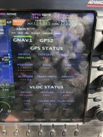
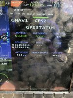
Not great quality but here is a few screen shots from my AFS PFD today. I really didn’t know how to interpret what I was seeing here. It looks like the GPS2 is getting a signal? I have a detailed equipment list but don’t see another GPS or antenna listed. GNAV1 is definitely the GTN 650.
 

Attachments

  • IMG_8568.jpeg
    IMG_8568.jpeg
    2.3 MB · Views: 27
  • IMG_8567.jpeg
    IMG_8567.jpeg
    2.5 MB · Views: 27
I see no attachments (screen shots) ?
Also - from earlier "Did you know you can capture screen shots of the EFIS display by pressing & holding the EFIS bottom right button for a 3 second count ?
These screen shots can be transferred to you SDcard later by tapping Set-Logs-Scrnshots (of course must have a SDcard installed or will go to USB stick in back)"
These will be high quality either .BMP (if early s/w) or .JPG (if later s/w).
 
Not great quality but here is a few screen shots from my AFS PFD today. I really didn’t know how to interpret what I was seeing here. It looks like the GPS2 is getting a signal? I have a detailed equipment list but don’t see another GPS or antenna listed. GNAV1 is definitely the GTN 650.
Email me the picture or call me from the plane: [email protected]
 
Oops, I forgot to add pictures but edited the original post with pictures. To answer, I didn’t try to do a screen shot on the EFIS yet.
 
Oops, I forgot to add pictures but edited the original post with pictures. To answer, I didn’t try to do a screen shot on the EFIS yet.
From what I see - You DO have a GPS puck antenna which is receiving data (GPS2) - Now you need to go physically find it. By the way, you likely took the pic from the PFD or left screen If you do the same thing from the other screen you'll likely get a nice screen showing all the Sat's the receiver is picking up etc. The GPS puck antenna's are typically connected to a serial port on the MFD screen.
The Pic for GNAV1 appears to not have reception of Sat's yet, but the GTN is ON.
Attached find 2 PDF's - the scrnshots of my PDF (with comments) and my MFD (with comments) - shows what yours will likely appears as
I really think Rob's advice to call their tech support from the plane is a GREAT offer!
 

Attachments

  • MFD ScrnShots 6-12-24 gnd.pdf
    328.3 KB · Views: 8
  • PFD ScrnShots 6-12-24 gnd.pdf
    434.3 KB · Views: 4
Thanks for the info! I’m going to be out on a trip but will sort thru and report back when I get back. This has been a different learning experience as most of my training on ”advanced avionics suites” has been at a formalized center with a detailed list of equipment, simulator and experienced instructor.
Concerning the puck antenna, there still has to be a second GPS receiver somewhere or is it internal to the AFS?
 
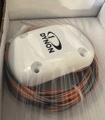
The Dynon GPS-250 is a single unit, the GPS receiver is mounted inside the Antenna. It should be mounted on the top of the aircraft, it could have been located on the glare shield or under the engine cowl.

Dynon GPS-250.jpg
 
Thanks, I had no idea this even existed. I have zero experience with exp aircraft so this is like starting over. I’m currently teaching my daughter to fly and reminiscing about some of the terminology used in past aircraft. My current aircraft (Pilatus NG), magenta needles is designated as FMS. This is interesting as I don’t see ”the box” as a true FMS, it is only GPS. There two antenna and receivers but “mixed” and no option to select either GPS. On the same aircraft nav1 and nav2 would designate loc1, nav1, loc2 and nav2 depending on the nav range (frequency) selected. On some of the early Collin’s 4 suites there was a LRN switch for GPS (long range navigation) with some having input from INS (Inertial) also.
 
"I have zero experience with exp aircraft so this is like starting over."
I urge you to create comprehensives functional diagrams of all your aircraft systems (Fuel, Electrical, Pitot-Static, Avionics including ADAHRS, EFIS back-up battery etc.) & components, physically find the piece parts & confirm how they interconnect.
Experimental aircraft are ALL different, have different levels of documentation - some documentation provided by a previous owner may be better than others.
As an example - You have a GTN650 which has GPS & VOR/LOC capabilities. Many plane builder/operators do NOT install VOR/LOC/GS antenna's so even if you tune a VOR or LOC freq - it's unusable. So Identify & verify while on the ground before you need something in the air.
There is NO Flight Safety Training center or courses for these planes, but there ARE a lot of people out here who will help you.
Hopefully this helps.
Happy reading.
 
Thanks, I had no idea this even existed. I have zero experience with exp aircraft so this is like starting over. I’m currently teaching my daughter to fly and reminiscing about some of the terminology used in past aircraft. My current aircraft (Pilatus NG), magenta needles is designated as FMS. This is interesting as I don’t see ”the box” as a true FMS, it is only GPS. There two antenna and receivers but “mixed” and no option to select either GPS. On the same aircraft nav1 and nav2 would designate loc1, nav1, loc2 and nav2 depending on the nav range (frequency) selected. On some of the early Collin’s 4 suites there was a LRN switch for GPS (long range navigation) with some having input from INS (Inertial) also.
You really need to call Rob at AFS.
He can help you understand how your aircraft is configured and answer your questions.

Download the manual.
It is really nicely documented with images of each screen.
 
I might be wrong, but in my AFS with TruTrak setup altimeter sync isn't necessary.
The manual says:

I never use those modes directly from the autopilot's control, only via the EFIS. As long as I control the autopilot via the EFIS it climbs to the correct altitude, and I never sync the altimeter.
 
Follow up question, please reference my equipment list from the original post.
When I’m attempting to use nav with the autopilot the button will only show tan and not lock into nave mode (green). I have tried this in GNAV1, GPS2 and internal flight plan mode. I’m aware of the limits to transition to “green nav” and have centered the CDI on each attempt. All other modes of the auto pilot seem to be functioning correct, I just can’t get the nav to lock on. I haven’t tried nav with ground based navigation.
 
Last edited: