
Van's Air Force
You are using an out of date browser. It may not display this or other websites correctly.
You should upgrade or use an alternative browser.
You should upgrade or use an alternative browser.
My experience so far with the IPad in the cockpit
- Thread starter Brantel
- Start date

brian
Well Known Member
temporary fix OK
I was able to temporarily make it work by just clamping it to my regular kneeboard and clamping a shop rag over that. I'd lift the rag some when i wanted to read it. Pretty cobby, but it worked. I have a real mount and 2 different glare shields coming from Amazon. Will report on how effective they are when i try them out.
I was able to temporarily make it work by just clamping it to my regular kneeboard and clamping a shop rag over that. I'd lift the rag some when i wanted to read it. Pretty cobby, but it worked. I have a real mount and 2 different glare shields coming from Amazon. Will report on how effective they are when i try them out.
brian
Well Known Member
some definitive answers on glare shields
I bought and installed 2 of the most-recommended glare screens mentioned here. I got them from Amazon. Here are my impressions and the results of my testing with them.
POWER SUPPORT HD:
http://www.amazon.com/gp/product/B004U5EJQM
costs twice as much
packaging nearly impossible to open
1 piece included
no instructions whatsoever - outside of packaging is entirely in Japanese
MEDIA DEVIL:
http://www.amazon.com/gp/product/B004ZXZK4O
costs half as much
you get 2 pieces
comes with very detailed instructions with the package, and web support with more instructions for getting a good fit
PERFORMANCE:
For testing, I put the Power Support over one half of the screen and the Media Devil over the other half. Then I slid the WingX sectional back and forth under each half, so I was comparing the same part of the sectional. A previous poster had mentioned that the Power Support cut down on the brightness. I could see no reduction in brightness from either half; they appeared to be identical. For glare reduction and readability, I found the Power Support to be VERY SLIGHTLY less glare and more readable in the glare than the Media Devil.
OTHER:
The Media Devil comes with a protective sheet on BOTH sides. First, you clean the screen with the cloth provided in both kits. You pull one tab, remove the bottom protective sheet, then carefully lay it on, using the plastic card provided with the Media Devil to smooth out bubbles. A credit card would work equally well. When you're all done, you pull off the top protective sheet. This second top protective sheet gave the Media Devil a smoother surface after installation than the Power Support.
The Media Devil instructions also described how to use something like shipping tape to remove any tiny dust particles that get trapped under the shield during installation.
It's ironic - my first installation, done at the hangar and in a hurry because I was ready to take off, was the cleanest. Later at home, when I was doing this testing, I had a bear of a time getting it so there were no tiny dust particles trapped under the screen. It's pretty easy to get bubbles out, especially using the plastic card provided with the Media Devil or a credit card, but getting those last "dust dots" out can be hard. Sometimes going after one seemed to introduce one (or more) additional new ones. And my house is pretty dust-free; certainly more so than the hangar. So, my advice is that if you'd gotten the dust dots and bubbles out of the main viewing area, but maybe some left over the black screen border, just leave them.
Overall, especially with all the good instructions and the fact that the Power Support effectively costs 4 times as much for each sheet, I'd recommend the Media Devil.
AviatorBoy
I'm New Here
Do most find a Yoke mountable device preferable over the current iPad kneeboard solution?
I am a software developer interested in creating the best tool for the cockpit.
I know there are currently many systems like the Garmin 696, and combinations of various software (ForeFlight, Xwing) with the iPad.
Do you think you can build a better system and application? I think so.
Please spend 12 minutes on the following survey to help me understand your needs and your thoughts on the limitations of existing solutions.
http://kellogg.qualtrics.com/SE/?SID=SV_0i9J5FSxbYZryUk
Last edited:
Mike S
Senior Curmudgeon
Welcome to VAF!!!!
Tom, welcome to VAF.
My wife and I just flew to Osh and back using the Ipad, and a couple other panel mounted GPS devices, the I pad was the easiest and most helpful by far.
The RV series does not use a yoke, so your question about yoke mounting is moot.
I have Skycharts in my Ipad, and find it to be pretty good, wish I could rubber band the route, and it would be sweet if it had real time weather capability.
AviatorBoy
I'm New Here
Mike, Thanks for the warm welcome.
Sorry, thought I might capture the attention of a few pilots who flew non-RV aircraft.
It sounds like a lot would like real-time weather? But, is that feature alone enough to cause you to buy another non-iPad device?
Also, my understanding on latest pricing is that real-time weather WSI or ADS-B or XM is really expensive!
Please fill out my survey, your wisdom would really help me understand your needs. If you'd be so kindly to forward it on to your aviation friends too, I'd be forever grateful.
http://kellogg.qualtrics.com/SE/?SID=SV_0i9J5FSxbYZryUk
brian
Well Known Member
Also, my understanding on latest pricing is that real-time weather WSI or ADS-B or XM is really expensive!
Yes, very expensive. I'd hoped to get a "show special" at OSH on the Skyradar ADS-B, but they weren't offering any, so I didn't buy. I think the choices for ADS-B are going to be increasing and the prices decreasing with time. By far, the most economic real-time weather now is a handheld Garmin with XM WX. The Garmin includes the receiver and antenna, an expensive option for panel-mount GPSs, so the only cost is $35/mo.
Mike S
Senior Curmudgeon
Please fill out my survey, your wisdom would really help me understand your needs.
http://kellogg.qualtrics.com/SE/?SID=SV_0i9J5FSxbYZryUk
Done.......
brian
Well Known Member
My wife and I just flew to Osh and back using the Ipad, and a couple other panel mounted GPS devices, the I pad was the easiest and most helpful by far.
I have Skycharts in my Ipad, and find it to be pretty good, wish I could rubber band the route, and it would be sweet if it had real time weather capability.
Try WingX and ForeFlight. It costs little or nothing to try them out, and they both have powerful rubberbanding.
I flew to OSH & back (from NH) with the Garmin 496 and iPad with WingX, Foreflight, and Garmin Pilot My-Cast. I used all 3 extensively before flying, for planning the trip and getting accustomed to using them. I found WingX clearly superior to the others, FF was "OK", with a couple things it did better than WingX, and the Garmin MyCast was a distant 3rd place. I also have FlightGuide3 iEFB, which is just sectionals & little or no route planning & Moving Map. If I get a chance, I hope to write up a detailed review here of all them and their plusses and minuses.
I use the iPad in portrait mode, "upside-down", so the button is on top. It's in portrait mode to better fit how I mount it (on a RAM mount between the seats). With a side-by-side plane, portrait minimizes how much width gets used up. It's upside-down so that the cover hinges on the right, away from me. Normally, I don't have it open all the time, but I cover and open it as needed. Also, I bought yet another ipad holder at OSH (Vogel's brand), because the RAM brand holder interferes with the cover mounting and closing properly. The new one doesn't interfere with the cover, but I did find out after I bought it and used it for the trip home that it lets the iPad swivel freely, rather than locked down, which isn't great, but wasn't a problem on the flight.
I saw a plane at OSH that had the iPad mounted over on the RT side, at about a 45 degree angle, facing the pilot, so I think I will try making a RAM mount that goes on that brace (sorry - don't have the part number) that goes between the panel and the canopy opening.
The much-discussed screen glare was not a problem at all for me on any of the legs. When the sun was hitting the iPad directly, I just laid my cardboard "HBC (homebuilt camping)/VFR (VFR departure)" sign on the top of the glare shield and that shaded the iPad.
I'm sure it's only a matter of time before makers of EFIS and autopilot systems incorporate Bluetooth and/or wi-fi. In fact, I think there was one vendor at OSH who announced such a thing. The iPad and its apps are incredibly useful for flight planning, especially a long trip.
Last edited:
rleffler
Well Known Member
Try WingX and ForeFlight. It costs little or nothing to try them out, and they both have powerful rubberbanding.
I'm sure it's only a matter of time before makers of EFIS and autopilot systems incorporate Bluetooth and/or wi-fi. In fact, I think there was one vendor at OSH who announced such a thing. The iPad and it apps are incredibly useful for flight planning, especially a long trip.
Navworx has a wi-fi option on their ADS600-B that allows ForeFligiht and WingX (or will shortly) to receive traffic and wx from ADSB.
bob
brian
Well Known Member
Navworx has a wi-fi option on their ADS600-B that allows ForeFligiht and WingX (or will shortly) to receive traffic and wx from ADSB.
aha - worX. I'd heard about Navworx, but couldn't find it anywhere because I wasn't spelling it with an X.
I looked it up, but it's very expensive. Almost $3k for the ADS-B and the wireless link to the iPad, in 2 boxes. That's about 80 months of XM subscription on the GPSMap 496.
The Skyradar ADS-B is all in one box and costs $950 for the current single-band version and $1100 for the new dual-band ver coming out in Sept.
I'd thought the Skyradar was too expensive, but the Navworx makes it seem like a good deal. I guess I'll just stick with my XM subscription.
rleffler
Well Known Member
aha - worX. I'd heard about Navworx, but couldn't find it anywhere because I wasn't spelling it with an X.
I looked it up, but it's very expensive. Almost $3k for the ADS-B and the wireless link to the iPad, in 2 boxes. That's about 80 months of XM subscription on the GPSMap 496.
The Skyradar ADS-B is all in one box and costs $950 for the current single-band version and $1100 for the new dual-band ver coming out in Sept.
I'd thought the Skyradar was too expensive, but the Navworx makes it seem like a good deal. I guess I'll just stick with my XM subscription.
You are comparing apples and oranges......
The ADS600-B is a transceiver, whereas the Skyradar is just a receiver. The other difference appears to be that Navworx will integrate with your EFIS, GNS-430/GTN-650, and GTX330, whereas the Skyradar appears to just support the Apple devices at the moment.
Not that this makes one better than the other, just different missions and requirements.
lluciani
Active Member
Not seeing the glare problem reported by others
I have about 20 hours of flying x-country with an iPad strapped to my inexpensive kneeboard. Some was at night but most in broad daylight in my RV8. Cloudy and clear.
The iPad screen is polarized. I'm not sure if this is to reduce glare or a side effect of something else. I have confirmed this with my polarized sunglasses. With them on the screen is black in portrait orientation.
I don't know if the mildly tinted canopy or polarization makes a difference but I have not had any problems with glare. None. Not even with the noon sun in my RV8 at 10,000 feet.
I think having it on a kneeboard in portrait orientation is the way to minimize glare. I am also using ForeFlight which I think is fantastic.
n981ms
Well Known Member
E Filing flight plan with Foreflight from Bahamas works
I posted this elsewhere but will here also. I filed IFR from the Bahamas to Fort Pierce while in the Bahamas with Foreflight on the Ipad. I suspect fltplan.com and other electronic filings would also work. Gotta love the Ipad. When in flight weather is available and affordable it will be just about perfect. I think it is the best thing for aviation since the gps.
I posted this elsewhere but will here also. I filed IFR from the Bahamas to Fort Pierce while in the Bahamas with Foreflight on the Ipad. I suspect fltplan.com and other electronic filings would also work. Gotta love the Ipad. When in flight weather is available and affordable it will be just about perfect. I think it is the best thing for aviation since the gps.
humptybump
Well Known Member
I find ForeFlight on the iPad to be a great planning tool. I wish it's weather briefing info were better organized. I also find it is good for situational awareness inflight. However, it has failed too many times on me to be my primary "integrated" GPS. I'll most likely get a Garmin 696 until I decide to do a glass panel.
I love my iPad.
However, the reasons against it for my primary GPS are:
(1) I need a GPS that will feed the autopilot.
(2) I need a device that does not lock up (the iPad can lock up although I've found if I do a full reboot of the iPad as part of my pre-flight work, it is fine)
(3) I need a device that is more heat tolerant (even in a 65degree cockpit, when the face of the iPad was in direct sun, it shut down after about an hour; directing a vent at it solved the problem) - the iPad was not hot to the touch but the internal sensor disagreed.
I'm sure there will be configurations that will eventually work but "simple is good" and there is not much simpler that a serial cable from GPS to AP.
deej
Well Known Member
Navworx has a wi-fi option on their ADS600-B that allows ForeFligiht and WingX (or will shortly) to receive traffic and wx from ADSB.
Ah! This is EXACTLY what I've been waiting for! Any idea when this will be available? They don't have any info on their website yet saying they will work with an iPad. I'm looking for WingX integration in particular.
-Dj
w1curtis
Well Known Member
RN-370
it is a Roving Networks RN-370 WiFi module. You have to select the "Buy Now" tab to order it from Navworx. But it is a generic device that you can buy from any Electronics supplier.
http://www.rovingnetworks.com/WiFi-Serial.php
http://www.rovingnetworks.com/Docs/WiFly-RN-370-UM.pdf
Ah! This is EXACTLY what I've been waiting for! Any idea when this will be available? They don't have any info on their website yet saying they will work with an iPad. I'm looking for WingX integration in particular.
it is a Roving Networks RN-370 WiFi module. You have to select the "Buy Now" tab to order it from Navworx. But it is a generic device that you can buy from any Electronics supplier.
http://www.rovingnetworks.com/WiFi-Serial.php
http://www.rovingnetworks.com/Docs/WiFly-RN-370-UM.pdf
RV7AV8R
Well Known Member
iPad used Seattle to osh
I used my iPad on the trip to OSH and back. It was very helpful to pan ahead looking for alternate airports and for airport information. The gps feature was not so useful to me since I have a panel mount gps. I have an 18 inch Ram mount between the seats (rv7) which worked well but it can catch the right stick ptt button and lock the stick. Not an issue once I figured out why the stick wouldn't move. The most valuable tool on this flight where weather was an issue was xm on my 396, especially metars. The combination of 396 and iPad with Foreflight made the flight easy.
I used my iPad on the trip to OSH and back. It was very helpful to pan ahead looking for alternate airports and for airport information. The gps feature was not so useful to me since I have a panel mount gps. I have an 18 inch Ram mount between the seats (rv7) which worked well but it can catch the right stick ptt button and lock the stick. Not an issue once I figured out why the stick wouldn't move. The most valuable tool on this flight where weather was an issue was xm on my 396, especially metars. The combination of 396 and iPad with Foreflight made the flight easy.
rleffler
Well Known Member
As William already stated the wifi device is available from multiple sources, including Navworx.Ah! This is EXACTLY what I've been waiting for! Any idea when this will be available? They don't have any info on their website yet saying they will work with an iPad. I'm looking for WingX integration in particular.
-Dj
WingX is already supporting this feature. Foreflight support I was told would be soon.
deej
Well Known Member
WingX is already supporting this feature..
Thanks!
In the ADS-B setup for WingX, it looks like it is only currently supporting FIS-B (weather), but not yet TIS-B (traffic). Did you happen to talk to Hilton or NavWorx at OSH and did they give any indication when TIS-B from the NavWorx device would be supported in WingX?
-Dj
rleffler
Well Known Member
Thanks!
In the ADS-B setup for WingX, it looks like it is only currently supporting FIS-B (weather), but not yet TIS-B (traffic). Did you happen to talk to Hilton or NavWorx at OSH and did they give any indication when TIS-B from the NavWorx device would be supported in WingX?
-Dj
Bill Moffett implied both traffic and weather at OSH. However, only the Hilton folks can answer that question. Give them a call and ask.
deej
Well Known Member
Bill Moffett implied both traffic and weather at OSH. However, only the Hilton folks can answer that question. Give them a call and ask.
The response from Hilton is:
"We have not tested the NavWorx hardware with WingX Pro7 although the NavWorx folks tell us that they have and it works fine. WingX Pro7 currently does not show traffic from ADS-In receivers and we are making a determination if we should in the future."
-Dj
David Paule
Well Known Member
I have an early iPad and use SkyCharts Pro. Since the data presentation is poor (this is the line of data at the bottom I'm referring to) I clip an Airmap 600C where it's handy, and have that set to the data box display. I put the same route info in both, and can change both in the air.
Since the two systems are separate they provide some redundancy to each other.
Dave
Since the two systems are separate they provide some redundancy to each other.
Dave
David-aviator
Well Known Member
Really Impressive Technology...
I've read just about every page of this thread trying to get spun up on the IPAD in an RV - like answering the question, what's all the fuss about?
The technology of this device is totally amazing. I was blown away in 1985 when the MAC was introduced and have been a fan ever since, this thing is at least 10 light years beyond it. Wow!
But that being said, as far as a moving map is concerned, what is the big deal? My old Garmin 295 is a pretty good navigator, how is the IPAD better other than it is 10 years newer? A moving map is a moving map.
It appears the IPAD's most useful function is replacing a bag full of charts and approach plates. Now that is a good idea. The airlines are going for it not out of any love for pilots, the IPAD is cheaper than paper or they would not do it.
The IPAD is truly a marvel. But in my book it is a fad right now. I spend too much time on the internet as is and do not need to be carrying that thing around so as to be "connected" perhaps even in flight via G3 cell phone service.
How the devil will one keep an eye out for enemy fighters with a functioning IPAD on board?
pierre smith
Well Known Member
Hi David
I carry my iPad on cross-countries but seldom look at it, since I have a 496 and 430W.
I can instantly tap on an airport and pull up all the approach plates if needed.
On long trips, my wife will move around the map to see interesting places or to know exactly where we are, relative to cities she knows.
The absence of cumbersome paper charts is worth every cent.
Best,
RV7AV8R
Well Known Member
iPad failed to keep up
This weekend my iPad had problems keeping up and also would show positions 20-50 miles in error. My 396 also had problems but was better than the iPad. I think it may have been the reported (aopa) sunspot activity, but of course have no way to know for sure. If it was sunspots, the iPad is much more sensitive to them than the garmin 396.
This weekend my iPad had problems keeping up and also would show positions 20-50 miles in error. My 396 also had problems but was better than the iPad. I think it may have been the reported (aopa) sunspot activity, but of course have no way to know for sure. If it was sunspots, the iPad is much more sensitive to them than the garmin 396.
deej
Well Known Member
But that being said, as far as a moving map is concerned, what is the big deal? My old Garmin 295 is a pretty good navigator, how is the IPAD better other than it is 10 years newer? A moving map is a moving map.
Interestingly enough I just replaced my Garmin 295 with the iPad running WingX because I was so much more impressed with the capabilities of the iPad.
Here are some of the reasons:
1) Screen size and quality. The 295 was okay, but the size of the display on the iPad makes it much easier to see, and the quality is much better.
2) Terrain. WingX has it, 295 does not.
3) Cost of database updates. WingX - $99 per year. 295 - somewhere around $45 every 6 weeks.
4) Flight planning on WingX is far superior to the 295. In addition, you can file flight plans right from the iPad.
5) Weather. WingX has it, 295 does not. WingX also has the capability to do ADS-B with the purchase of an external unit, which I am interested in, and the 295 does not.
6) As noted, easy access to charts and sectionals w/o paper. Major plus to WingX for much easier access to the A/FD information, and it is presented on the same screen so you don't have to leave the map screen to get to it versus the 295.
7) Software updates to add new features exists on WingX, no updates available for the aging 295. An example is last month WingX added 3D synthetic vision and an obstacle database that you can purchase for an additional $99 per year. That's $198 per year for full charts, terrain database, obstacle database, and 3D vision with updates every 6 weeks.
8) Other misc things that just make WingX far superior to the 295. I flew with them both in the plane to compare, and after 2 flights I was completely convinced.
The one thing I miss from the 295 is the graphical HSI displayed side by side to the moving map. WingX does have a simple course indicator, but I don't like it as much as the full HSI that the 295 offers. I've written WingX to ask if they might be able to add this.
I think the 295 is a great little GPS, and I'll keep it in my flight bag as a backup, but if you test fly the 295 and the iPad I have no doubt you'll figure out the "big deal" in no time...
-Dj
Cary Brooks
Member
iPad w/foreflight
Man what an awesome tool. I use the I pad with a GNS 5870 MFI. Blutooth external gps I slip on the dash. I have had it to 300knts at 24000 ft with 10 meter accuracy in a king air 200, RV 7,8 and 10s. The fore flight HD has geo referenced approach plates and taxi ways that work beautifully. Looking for cheap fuel type in the closest airport identifier and boom all the surrounding airports and fuel prices pop up. Want tom plan a flight put departure and destination identifiers with altitude and wind corrections are automatically calculated, along with fuel burn, eta the works. Plan an IFR flight legs are figured with everything you need. Want to do you weather brief and file your flight plan just hit the send key. There is always the HUD app that serves as a back up glass panel in case of a failure and with the 3 accelerometers built in works fine. Gps altitude is accurate to 100ft. Not bad for a back up. I was dodging pop up weather this week end on my way to Port Aransas tx and when my satellite weather didn't update I switched fro vfr to radar and had the info I needed. It will also give you current metars for airports on your route once I learned everything this piece of equipment can do I realized what an amazing tool it really is. My daughter and son play games on it if they get bored in the cockpit and I also plug it in to my mp3 jack on my intercom for some great tunes. I have Bose a20 headsets and the sound is second to none. Learn what it can do for you and don't be hating just because your eyes ain't what they used to be.
Man what an awesome tool. I use the I pad with a GNS 5870 MFI. Blutooth external gps I slip on the dash. I have had it to 300knts at 24000 ft with 10 meter accuracy in a king air 200, RV 7,8 and 10s. The fore flight HD has geo referenced approach plates and taxi ways that work beautifully. Looking for cheap fuel type in the closest airport identifier and boom all the surrounding airports and fuel prices pop up. Want tom plan a flight put departure and destination identifiers with altitude and wind corrections are automatically calculated, along with fuel burn, eta the works. Plan an IFR flight legs are figured with everything you need. Want to do you weather brief and file your flight plan just hit the send key. There is always the HUD app that serves as a back up glass panel in case of a failure and with the 3 accelerometers built in works fine. Gps altitude is accurate to 100ft. Not bad for a back up. I was dodging pop up weather this week end on my way to Port Aransas tx and when my satellite weather didn't update I switched fro vfr to radar and had the info I needed. It will also give you current metars for airports on your route once I learned everything this piece of equipment can do I realized what an amazing tool it really is. My daughter and son play games on it if they get bored in the cockpit and I also plug it in to my mp3 jack on my intercom for some great tunes. I have Bose a20 headsets and the sound is second to none. Learn what it can do for you and don't be hating just because your eyes ain't what they used to be.
Here's the direct link to the story:
http://www.macrumors.com/2011/08/23...00-ipads-to-pilots-as-electronic-flight-bags/
Think we'll be able to have our iPads on during critical phases of flight from now on? Dare to dream...
http://www.macrumors.com/2011/08/23...00-ipads-to-pilots-as-electronic-flight-bags/
Think we'll be able to have our iPads on during critical phases of flight from now on? Dare to dream...
Our company is supposedly going to issue iPads as well, since our Lido charts were designed for EFB's and having crew sets is a pretty large aggravation. Hopefully it will happen soon.
App idea for iPad...
Is there anything like this that anyone has ever heard of? Copying IFR clearances have always been tough for me, especially on long unfamiliar legs. I hate getting yelled at by controllers right before going into the clouds. The iPad seems ripe for this type of app. Picture your screen with the standard DRAFT down the left side. 1) Before calling for you clearance you would input your expected destination next to D. 2) Then next to your route (R) would be columns with every possible en-route airway and VOR marker, ordered by most likely with a big DIRECT button. As the controller reads you your clearance you would just click on the names followed by an airway or "direct" button. As you did, your choices would diminish making it easier to find the next one. Altitudes (A) would be in list appropriate for direction of travel of course. All possible departure frequencies (F) would pop up and finally an easy way to enter your transponder code. The time and frustration saved would make IFR much more enjoyable for the GA pilot. Any thoughts?
Is there anything like this that anyone has ever heard of? Copying IFR clearances have always been tough for me, especially on long unfamiliar legs. I hate getting yelled at by controllers right before going into the clouds. The iPad seems ripe for this type of app. Picture your screen with the standard DRAFT down the left side. 1) Before calling for you clearance you would input your expected destination next to D. 2) Then next to your route (R) would be columns with every possible en-route airway and VOR marker, ordered by most likely with a big DIRECT button. As the controller reads you your clearance you would just click on the names followed by an airway or "direct" button. As you did, your choices would diminish making it easier to find the next one. Altitudes (A) would be in list appropriate for direction of travel of course. All possible departure frequencies (F) would pop up and finally an easy way to enter your transponder code. The time and frustration saved would make IFR much more enjoyable for the GA pilot. Any thoughts?
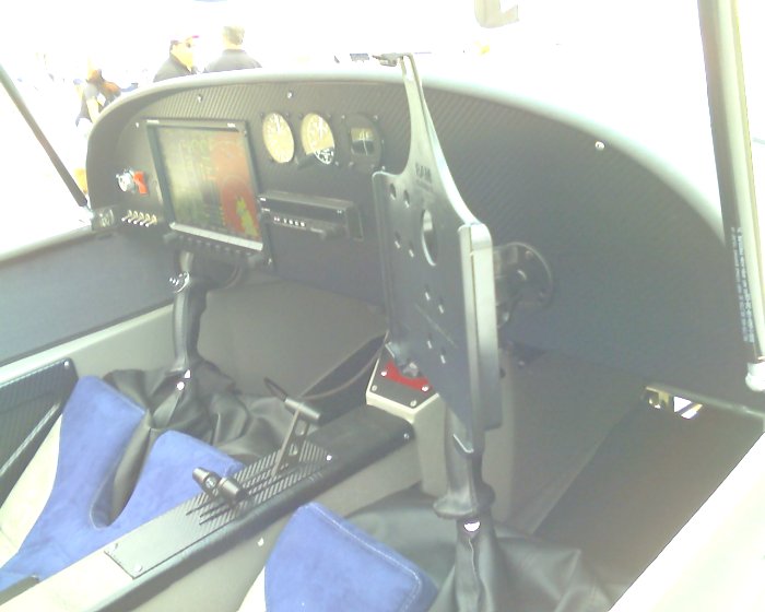
iPad2 in RV12
Last July, I flew a 2400 nm VFR cross country; Lorain OH to Petaluma CA, in my RV12 using the iPad2. It was mounted on the center tunnel under the panel, visible but unaffected by glare. I took no paper charts and the Foreflight software and moving map skirted me past MOAs, restricted areas, the US-Mexican border and across mountains within my and the RV12's capability. I also had a backup on my iPhone and a Garmin 496. I used the 12's DC power plug to keep the iPad and iPhone charged. Using the iPad to plan the legs also allowed an accurate route for Wx briefing and filing flight plans. It was a successful flight.
Last July, I flew a 2400 nm VFR cross country; Lorain OH to Petaluma CA, in my RV12 using the iPad2. It was mounted on the center tunnel under the panel, visible but unaffected by glare. I took no paper charts and the Foreflight software and moving map skirted me past MOAs, restricted areas, the US-Mexican border and across mountains within my and the RV12's capability. I also had a backup on my iPhone and a Garmin 496. I used the 12's DC power plug to keep the iPad and iPhone charged. Using the iPad to plan the legs also allowed an accurate route for Wx briefing and filing flight plans. It was a successful flight.
panhandler1956
Well Known Member
Last July, I flew a 2400 nm VFR cross country; Lorain OH to Petaluma CA, in my RV12 using the iPad2. It was mounted on the center tunnel under the panel, visible but unaffected by glare. I took no paper charts and the Foreflight software and moving map skirted me past MOAs, restricted areas, the US-Mexican border and across mountains within my and the RV12's capability. I also had a backup on my iPhone and a Garmin 496. I used the 12's DC power plug to keep the iPad and iPhone charged. Using the iPad to plan the legs also allowed an accurate route for Wx briefing and filing flight plans. It was a successful flight.
That's cool - on several different levels.
JerryG150
Well Known Member
hope it works ...
I cancelled my XM weather for my Gamin 496 in my RV-12. I was hoping to use my new Ipad2 Wi-Fi, Iphone4 with hotspot and bluetooth GNS5870 MFI instead.
I'm hoping my hotspot Iphone4 will send a signal to the Ipad2 via Wi-Fi and my Ipad2 will receive GPS from my Bluetooth and I'll have a moving GPS with weather (radar and satellite views via Foreflight maps).
Do you think I will I receive all the necessary signals @ 5,000' and 140 knots on my Iphone4 (yes, I paid for the data and hotspot feature on my AT&T Iphone4) to send the hotspot signal to my Ipad2 Wi-Fi while it is receiving bluetooth info from my GNS 5870 MFI (GPS)?
I tried it once, but I think my settings were incorrect on the Ipad2 (wrong network) and it was a no go. Instead on removing the Ipad2 from my kneeboard holder and reworking the settings in my Ipads2 ... I decided to just fly the plane.
Think it should work ... or am I just dreaming?
n5lp
fugio ergo sum
...Do you think I will I receive all the necessary signals @ 5,000' and 140 knots on my Iphone4...
I have fiddled around with this some. On occasion I have received data at altitude but it is certainly nothing to count on.
The picture below is an exception. That photo was taken and immediately uploaded to Facebook one day when I happened to notice that I had 3G data coverage at 10,000 feet in the middle of nowhere.

Last edited:
You'll probably get better cell tower reception at or below 3,000' AGL. It becomes hit or miss above that in my experience. This due to the horizontal propagation inherent in cell antennae. You can get an external cell antenna (Don Pansier) and a Wilson amplifier (like the truckers use) and get acceptable cell data as high as 10K or more. Of course, you probably know cell use in flight is contrary to FCC regs in the U.S.
w1curtis
Well Known Member
Is there anything like this that anyone has ever heard of? Copying IFR clearances have always been tough for me, especially on long unfamiliar legs. I hate getting yelled at by controllers right before going into the clouds. The iPad seems ripe for this type of app. Picture your screen with the standard DRAFT down the left side. 1) Before calling for you clearance you would input your expected destination next to D. 2) Then next to your route (R) would be columns with every possible en-route airway and VOR marker, ordered by most likely with a big DIRECT button. As the controller reads you your clearance you would just click on the names followed by an airway or "direct" button. As you did, your choices would diminish making it easier to find the next one. Altitudes (A) would be in list appropriate for direction of travel of course. All possible departure frequencies (F) would pop up and finally an easy way to enter your transponder code. The time and frustration saved would make IFR much more enjoyable for the GA pilot. Any thoughts?
I think this may be of interest to you. Since Foreflight has airway decoding, I cant see paying $20 for this app.

http://itunes.apple.com/us/app/airways/id389813509?mt=8&ls=1

