What's new
Van's Air Force

Don't miss anything! Register now for full access to the definitive RV support community.

Known APRS Coverage Holes

petehowell

Well Known Member
How about we post known holes in APRS coverage and document with APRS.fi pics where possible. I know transmit power, antenna, sunspots and other things affect coverage, but I think we can get a good idea of bad spots. We might even be able to get someone to install a digi for us.

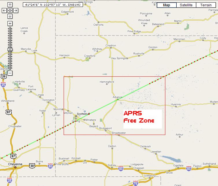
I'll start - Western Nebraska

West%20NE.JPG
 
A potential approach ...

Pete,

Might it be possible for someone to scan the "APRS database" and plot ALL of the points on a map similar to what "FlightAware" does to show all the traffic in the air?

It would not matter so much on a first pass as to the source of the transmissions, those places that have NO data would be initial places we would suspect.

Just a thought.

James
 
Using the total database of points is a great idea. Dump all transmitted points into a GIS, select say a 1 mile radius around each one, then invert the resulting coverage so the absence of coverage becomes the feature. Very simple in a GIS. Someone post where the continental US data is and I can have it done.
 
Pete,

Might it be possible for someone to scan the "APRS database" and plot ALL of the points on a map similar to what "FlightAware" does to show all the traffic in the air?

It would not matter so much on a first pass as to the source of the transmissions, those places that have NO data would be initial places we would suspect.

Just a thought.

James

Using the total database of points is a great idea. Dump all transmitted points into a GIS, select say a 1 mile radius around each one, then invert the resulting coverage so the absence of coverage becomes the feature. Very simple in a GIS. Someone post where the continental US data is and I can have it done.

You guys are much more versed in databases than I but I'm struggling to see how this would work. According to the blog belonging to the author of aprs.fi there is no way to strip out just airborne trackers:

Features being planned (in no specific order):

· list of flying objects (might not be possible in practice)


But even if you could, based on what I have observed, there are usually only 2-4 active aircraft trackers nationwide at any particular moment. As much as we like APRS, we are a tiny population compared to all aviation traffic. That is one reason I don't put much stock in the old-timers who say we are "destroying" the APRS network.

If you want to see APRS aircraft currently moving Look for the little airplane symbols

If you want to see a nationwide map of digipeaters, here they are:

This map may not be totally up to date and doesn't call out iGates.

Maybe I've totally missed what ya'll are talking about doing with the database. Not sure where you can grab the national database, but here are some links you might find interesting:

Static snapshot of last three seconds of beacons nationwide

Live iGate nationwide display

I still don't see how a database can reliably find the coverage holes since coverage depends on antenna, altitude, transmitter power, atmospheric conditions, ground traffic, terrain, etc, etc. Seems coverage appraisal would have to come primarily from actual flight experience.

But.....carry on! :)
 
Last edited:
You guys are much more versed in databases than I but I'm struggling to see how this would work. According to the blog belonging to the author of aprs.fi there is no way to strip out just airborne trackers:

<< snip >>

I still don't see how a database can reliably find the coverage holes since coverage depends on antenna, altitude, transmitter power, atmospheric conditions, ground traffic, terrain, etc, etc. Seems coverage appraisal would have to come primarily from actual flight experience.

But.....carry on! :)

Sam the idea is to simply plot ALL instances of APRS "pings". Would not matter if it was from the ground on a truck or from an airplane. Wherever you see a response, a plane is likely to be picked up there as aerial tends to be better than terrestrial.

Where there are no responses means there are likely no people and/or no igates. This would only serve as a first pass.

All data would be "plotted". Imagine plotting all of your flights and all of my flights and all of your buddy's truck-based transmissions. We would get a sense of SOME of the coverage that exists in the Southeast.

James
 
After looking at the real-time i-gate display it's pretty amazing that there is coverage in Nevada and Utah. They must have a decent RF digi backbone.

Here's a list of APRS servers http://www.aprs-is.net/APRSServers.aspx if you want to capture your own data.

Here's another interesting page you might find helpful http://aprsworld.net/

I think plotting the database is going to look a lot like a high altitude view of the ground at night. You're going to get a pretty good idea of where the activity is and where it isn't.

Paige
 
I talked to our GIS expert...yes, if given a list of received hits, she can easily create a map of the US with no hits.

So I need a list of all valid received pings from any kind of vehicle over, say, the last year. Minimum I need is just x and y (lat-lon). Datum and coordinate system used by each ping would be good too, but if not available we will assume NAD-83 and UTM, which is the most common for GPS. I don't need time, type of vehicle, really any other data, though that stuff won't hurt either.

Pings in the last few seconds, current aircraft, locations of digipeaters, etc. won't work. I assume the pings over the last few months or year will be several hundred thousand or a million or so but that's OK. Does someone in the APRS community collect this and keep it online?
 
Back
Top