What's new
Van's Air Force

Don't miss anything! Register now for full access to the definitive RV support community.

The Great North Road

n5lp

fugio ergo sum
DSC02331.jpg

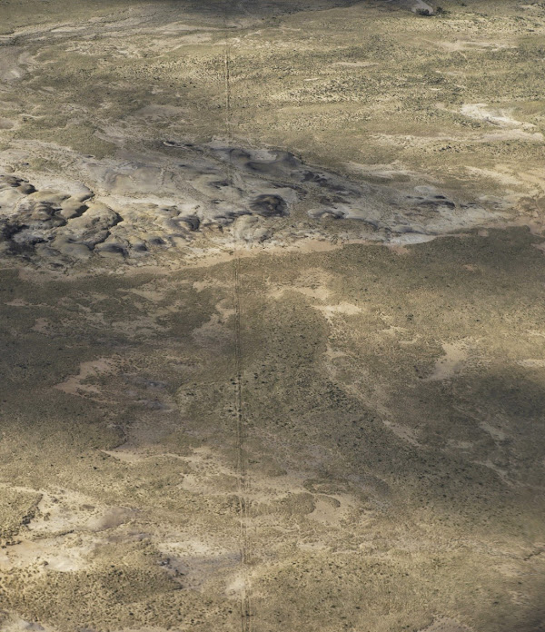
I like taking pictures from the RV. This is one of the least visually striking ones I would ever share publicly. Obviously desolate dry country and there is a linear feature from top to bottom. What might that be? Power line, road, fence? It does seem unusual that the feature goes pretty much straight no matter what it is crossing. There is no deviating for gullies and hills.

Well what is actually so unusual is that this is a road and it is around 1,000 years old and this section is almost exactly on a true north track. It is only because of our dry climate here that something so old is visible for so long.

This road average 9 meters wide but is sometimes wider and up to 4 lanes. It seems that it was more ceremonial than practical.

My RV flying has gone through several phases. Lots of aerobatics at the beginning, then long cross countries and now I mostly use it to look at stuff and there is really a lot of stuff to look at. I feel privileged.

Greatnorthsolstice.jpg


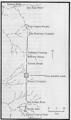
This graphic is from the Solstice Project
 
Last edited:
Great Stuff!

Larry,

Always love your aerial photos and background info.

Any more pics of the mystery airport from a while back?
 
Pete, I haven't seen any changes or activity at the secret airport for a long time. It seemed to go dormant along with changes in the US military mission in the mideast.

On the other hand there were TFRs this week at Jeff Bezo's rocket launch facility which is only a short distance away from the secret airport. I need to get over there again to see if I can figure out anything. Every time I go there there seems to be new pads or buildings.
 
Last edited:
Larry,
I'm curious. Did you know about The Great North Road and go looking or did you see the line and find what it was?
 
Larry,
I'm curious. Did you know about The Great North Road and go looking or did you see the line and find what it was?

Dave, there are many linear features out here, particularly pipelines, and I would never have figured out what this was if I just happened upon it. I had read about this years before, but it was a lecture on Chacoan culture at the local museum that finally motivated me to go look at it.

I have probably previously posted photos of interesting linear features that look like roads but are dikes that go for 10s of miles in very straight lines.
 
Larry,

We live in Durango and have taken guests to Chimney Rock several times. The guides there have pointed out a trail that goes directly from there to the Salmon Ruins. You can barely make out this trail, but the interesting part is that it heads straight no matter how difficult the terrain. Mesa Verde had a wonderful display in their museum fifteen years ago. It was a collection of photographs taken 100 years ago, placed next to recent photos taken from the same spots. In one picture you could see a tree that had fallen over a trail, still visible there 100 years later! You are right, this is a fascinating place to live. Thanks for your posts...they are always fun to read.

Jim
 
not that unusual .....

amazing stuff you find Larry, thanks for sharing....
but

I've seen lines like this many times.....


I think it's from the ancient 'Google Earth' gods, where they stitched the planet together.

right?

anyone?........

too early?:D
 
Last edited:
Larry, a(nother) fascinating picture that leads to another fascinating subject. Thanks for sharing these with us.

Have you viewed the Sun Dagger site from the air, which seems to have been the precipitating event for the Solstice Project? Perhaps you have a pic of that to share?

Jack
 
...Have you viewed the Sun Dagger site from the air, which seems to have been the precipitating event for the Solstice Project? Perhaps you have a pic of that to share?

Jack

I don't have a photo of that Jack. I have seen a television documentary about it but never thought of it as a subject for an aerial photo.
 
Thanks Larry

Larry, you brought to mind another spiritual road I try to follow:

...small is the gate and narrow the road that leads to life... Matt 7:13

Seems those ancient Navajo were looking for the same path. Thanks for the photo. I'm planning a trip to the Navajo Nation in June, I'll be looking for that remarkable feature.

John
 
It is fascinating to think about the circumstances under which that road or marker was built 1000 years ago.

The obvious thing about it is whoever did it had a tool to make it straight and the time and resources to do it. This mystery is how come?

Thanks for posting it Larry.
 
Found it Larry

Larry, Flew home from Cortez, Co to Baton Rouge Friday and diverted over to the north side of the Chaco complex to look for the Great North Road. It's hard to see just north of the Canyon and my photos didn't do it justice, but there was a definite track heading due north across the desert. Those canyons and mesas are truly beautiful in the early morning light.

To correct something I said earlier, I talked with a Navajo man about the Chaco and he said he didn't think they were related. Someone else told me that the closest known relatives of the Navajo are the Eskimo based on genetics and linguistics, but I haven't verified it and don't claim any special knowledge. John
 
Last edited:
Back
Top