
Van's Air Force
You are using an out of date browser. It may not display this or other websites correctly.
You should upgrade or use an alternative browser.
You should upgrade or use an alternative browser.
GRT and charts
- Thread starter BobTurner
- Start date

GRT web site now has info about geo referenced charts for the HX and HXr
Sweet! Great addition -- thanks for posting, and thanks GRT!
Outstanding update!
We've been testing and flying this new release for several weeks now and I have to say its outstanding. The information available makes flying safer and easier.
I used to always feel I needed my iPad with WingX handy for all the need to know and nice to have information, especially while IFR.
Now with this upgrade from GRT and Seattle I have everything I need right in front of me. I haven't opened my iPad in weeks in the cockpit. It's now my backup set of maps and charts.
Just remember, we still have to look outside...
Kahuna
Moderatoring
Yep its been running great over the past month or so. GRT has been taking our feedback, making changes, and now released. I guess my old approach plates application will be going away as its not needed anymore. Having the geo-referenced plates, charts, maps, and things, makes my old application to get the plates obsolete.
RVbySDI
Well Known Member
well, except for the difference in having to now pay for a subscription. Kahuna, I know there was some work involved on your end in being able to compile the data but it was nice to have it without having to pay a subscription for it.Yep its been running great over the past month or so. GRT has been taking our feedback, making changes, and now released. I guess my old approach plates application will be going away as its not needed anymore. Having the geo-referenced plates, charts, maps, and things, makes my old application to get the plates obsolete.
Kahuna
Moderatoring
well, except for the difference in having to now pay for a subscription. Kahuna, I know there was some work involved on your end in being able to compile the data but it was nice to have it without having to pay a subscription for it.
Dont worry. I wont be deleting it. It still works. And I will keep it up. It gets used by a lot of folks and mostly not by GRT users. Anyone that wanted the PDF plates on some device so they could have them in an organized fashion.
Yep its been running great over the past month or so. GRT has been taking our feedback, making changes, and now released. I guess my old approach plates application will be going away as its not needed anymore. Having the geo-referenced plates, charts, maps, and things, makes my old application to get the plates obsolete.
Is geo-referenced maps are also part of it and supported? I looked it pricing and it was not saying any thing on the geo-referenced, only that the charts, DP, Airport diagram/taxi way is included?
Any chance of this coming to the Sport SX series or is there a hardware limitation?
Is geo-referenced maps are also part of it and supported? I looked it pricing and it was not saying any thing on the geo-referenced, only that the charts, DP, Airport diagram/taxi way is included?
Everything is georeferenced.
KatieB
Well Known Member
Any chance of this coming to the Sport SX series or is there a hardware limitation?
No, sorry-- There are limitations with the Sport processor. Plus, the ability to display charts is something that sets the HX apart from the already-feature-rich Sport.
KatieB
Well Known Member
Dont worry. I wont be deleting it. It still works. And I will keep it up. It gets used by a lot of folks and mostly not by GRT users. Anyone that wanted the PDF plates on some device so they could have them in an organized fashion.
Mike, we really appreciate your work with the PDF approach plates over the years. They will still work for those who don't mind the extra work with setting up the download and don't care about geo-referenced data.
And we really appreciate all of your Team's work in getting these babies tested out for us in the real world.

KatieB
Well Known Member
Sectionals
In addition to geo-referenced approach plate data, a Seattle Avionics subscription also adds Sectionals, seen here:
 [/URL]
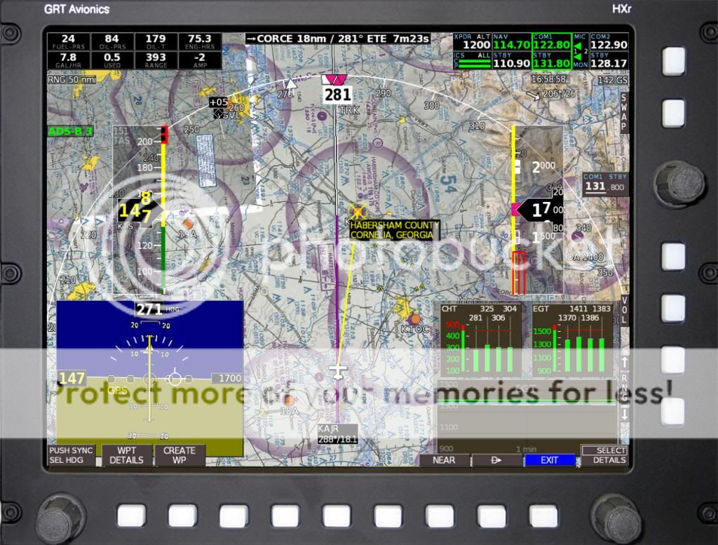
You can choose a VFR-only package that includes U.S. Sectionals and airport diagrams. We are currently the only EFIS vendor that offers a VFR-only package through Seattle Avionics.
In addition to geo-referenced approach plate data, a Seattle Avionics subscription also adds Sectionals, seen here:

You can choose a VFR-only package that includes U.S. Sectionals and airport diagrams. We are currently the only EFIS vendor that offers a VFR-only package through Seattle Avionics.
KatieB
Well Known Member
And for the HX guys...
One of the things I like about it is that we've kept many of the features of the regular moving map, such as the Map Selection Tool (shown above on the full-screen HXr Sectional) and extended runway centerlines, shown here.
 [/URL][/IMG]
One of the things I like about it is that we've kept many of the features of the regular moving map, such as the Map Selection Tool (shown above on the full-screen HXr Sectional) and extended runway centerlines, shown here.
Last edited:
KatieB
Well Known Member
Airspace Alerts & Chart Markings
If the EFIS calculates that your path will take you into "bustable" airspace, the yellow outline appears. Restricted and Prohibited areas are outlined in red for extra awareness.
I also like that the labels on the airports and navaids rotate with your map view, so if you use Track Up, you don't have to read them upside down.
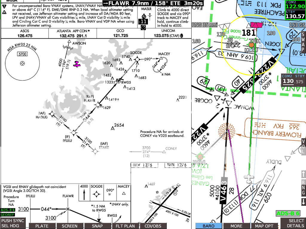
This is a raw screenshot from an HXr displaying both the approach plate and enroute chart, something that would be useful for transition into the terminal area if you have a second HXr screen. Here, the pilot was cleared to FLAWR and is now on ATC vectors to intercept the approach. The green line is the heading bug projection.
If the EFIS calculates that your path will take you into "bustable" airspace, the yellow outline appears. Restricted and Prohibited areas are outlined in red for extra awareness.
I also like that the labels on the airports and navaids rotate with your map view, so if you use Track Up, you don't have to read them upside down.
This is a raw screenshot from an HXr displaying both the approach plate and enroute chart, something that would be useful for transition into the terminal area if you have a second HXr screen. Here, the pilot was cleared to FLAWR and is now on ATC vectors to intercept the approach. The green line is the heading bug projection.


KatieB
Well Known Member
Oshkosh Arrival
The flight plan is drawn out on the chart like it normally would be for the moving map. The line is NOT GPS dependent, so if you lose GPS signal, the line stays on the chart-- just like it would as a pencil line on a paper chart. Additionally, if GPS is lost, the EFIS goes into "Dead Reckoning" mode and can calculate the aircraft's position fairly accurately for some time using the AHRS data. I actually used this feature myself a long time ago when I lost GPS signal on my way to an airshow in a Sport-equipped Jabiru LSA. I was amazed at how accurate it was-- I didn't even get lost. Anyway... here's the next screenshot, approaching RIPON.
 [/URL][/IMG]
Here, the ADS-B traffic came into view on the PFD as well.
 [/URL][/IMG]
The flight plan is drawn out on the chart like it normally would be for the moving map. The line is NOT GPS dependent, so if you lose GPS signal, the line stays on the chart-- just like it would as a pencil line on a paper chart. Additionally, if GPS is lost, the EFIS goes into "Dead Reckoning" mode and can calculate the aircraft's position fairly accurately for some time using the AHRS data. I actually used this feature myself a long time ago when I lost GPS signal on my way to an airshow in a Sport-equipped Jabiru LSA. I was amazed at how accurate it was-- I didn't even get lost. Anyway... here's the next screenshot, approaching RIPON.
Here, the ADS-B traffic came into view on the PFD as well.
Yeah, it's on an oil rig in the Gulf, just a couple of miles away.
Say, what are the three pink triangles in my picture? (The ones near the programmed destination, KRKP.)
I think they are the TRK that's steering the system. The two together are are indicatiing the actual track you programed into the GPS and the single is the desired track, so if you overlay the single between the two triangle you'll be flying on the desired track. In the NORTH up mode with the map centered like that it's hard for me to tell. Your actual track is the little white arrow way out in front of your plane and the display is telling you your heading is 046. It looks like you have ARC turned off so you do not get the compass rose displayed.
Look up at Post #16 and see the magenta triangle and squares. Those are Heading. The HDG is indicated by to Rectangles and a Triangle. If HDG is the active mode, they Rectangle/Triangle will be magenta and if TRK or ENAV or GNAV is active, the triangles will be Magenta. When not selected as the active lateral mode those indications are in white.
Last edited:
I think they are the TRK that's steering the system. The two together are are indicatiing the actual track you programed into the GPS and the single is the desired track, so if you overlay the single between the two triangle you'll be flying on the desired track. In the NORTH up mode with the map centered like that it's hard for me to tell. Your actual track is the little white arrow way out in front of your plane and the display is telling you your heading is 046. It looks like you have ARC turned off so you do not get the compass rose displayed.
Look up at Post #16 and see the magenta triangle and squares. Those are Heading. The HDG is indicated by to Rectangles and a Triangle. If HDG is the active mode, they Rectangle/Triangle will be magenta and if TRK or ENAV or GNAV is active, the triangles will be Magenta. When not selected as the active lateral mode those indications are in white.
Thanks for the explanation!
dmaib
Well Known Member
Thanks GRT!
I finally got the new software (2a) loaded in my Hxr and subscribed to the Seattle Avionics geo-referenced charts and plates. Got it all fired up in the hangar today and it really rocks!
Sorry no pix, but there are plenty before me on this thread and mine looks just like theirs! Hope to actually fly with it tomorrow.
Thanks again, GRT!
Kenny Gene
Well Known Member
GRT HX screens and Seatlle Avionics
Hey Troops,
Anyone out there have GRT HX screens that has downloaded 6a and Geo-Referenced charts without problems and charts appear on HX EFIS?? Boy do I want to hear from you!! PM will work also,
Kenny Gene
Wichita Kansas area
Rv 7a 294TC AWC 09-07 690 hrs sold 11-11
Rv 10 484TC AWC 10-10 350 hrs
Hey Troops,
Anyone out there have GRT HX screens that has downloaded 6a and Geo-Referenced charts without problems and charts appear on HX EFIS?? Boy do I want to hear from you!! PM will work also,
Kenny Gene
Wichita Kansas area
Rv 7a 294TC AWC 09-07 690 hrs sold 11-11
Rv 10 484TC AWC 10-10 350 hrs
tommylewis
Well Known Member
it works
I have HXs in both of our RVs and have loaded 6a and subscribed to the IFR stuff from Seattle Avionics. It works well. Today my wife did a practice IFR approach with the approach plate on the screen and it works great. What is the problem you are having?
I have HXs in both of our RVs and have loaded 6a and subscribed to the IFR stuff from Seattle Avionics. It works well. Today my wife did a practice IFR approach with the approach plate on the screen and it works great. What is the problem you are having?
Kenny Gene
Well Known Member
GRT HX with Seattle Avionics
I have 6a, inset memory stick before turning on master and nothing,, I have reviewed the GRT HX display settings and these are in "auto" and nothing!! I don't even get the soft key option for sec, charts or lo,,, my memory stick when clicking right key, properties, has 6.06 GB and I have plates, low and 38 states selected for sectionals. I'm Really frustrated!!
Kenny Gene
KatieB
Well Known Member
I have 6a, inset memory stick before turning on master and nothing,, I have reviewed the GRT HX display settings and these are in "auto" and nothing!! I don't even get the soft key option for sec, charts or lo,,, my memory stick when clicking right key, properties, has 6.06 GB and I have plates, low and 38 states selected for sectionals. I'm Really frustrated!!
Kenny Gene
Hi Kenny,
Sorry to hear it's not working for you. Here are a couple of questions to start with-- Are you using the Seattle Avionics Data Manager to download your files with a Windows PC, or are you using a Mac?
Also- What brand & size USB stick are you using? Sounds to me like the HX display unit is not recognizing the charts on the stick. The chart files could be in the wrong folder, or your USB stick might be in a format not recognized by the EFIS, which requires FAT32.
Kenny Gene
Well Known Member
Thank you everyone
Thank you everyone for your ideas. I did delete off one memory stick "chart data" file and re-downloaded Seattle Avionics, but I've not been able to get back to my 10 to try it out, however I'm doubtful this will be any different because I see that the files and file size on all 3 of my memory sticks are exactly the same. I'm going to re-load the GRT's with 6a and see if this works.
Thanks so much and I'll report back.
Kenny Gene

