What's new
Van's Air Force

Don't miss anything! Register now for full access to the definitive RV support community.

ForeFlight 8

I just watched a couple of videos on the new version of ForeFlight. I've used this app on my iPad for years and the next version looks like it will be awesome.
 
ForeFlight 8 is great -

I know there's always the Garmin Pilot vs ForeFlight debate, but ForeFlight8 looks impressive.

https://youtu.be/5ChSwhl4EUY

I've spent a few days with FF v8.0 and the demo video and announcements don't do it justice. Totally impressed with the new map technology, worldwide info, aeronautical info superbly displayed, and fast. Using Pro version and haven't re-visited the Basic features, but this is fantastic. It takes a little time to review all the changes. This is not something that one should load today, and fly tomorrow ... enough change to take your time to become accustomed. Then it will start to feel like an extension of your mind.

Context sensitive data is displayed with a few touches, and the buttonology seems to flow well. Readability is also much better graphically.

Not flying with it yet, trying to get ready for AW inspecition and first flight now. However, someone who is flying should do a quick review and comment.
 
I'll actually be using it in the air this week for my instrument checkride. So far, I've flown with it using the sim (x-plane) and I followed along with it on a commercial flight this weekend. The new map is FANTASTIC for IFR work. It's very clean and using the map in track up with right-side up labels is tremendous. The dynamic display of info depending on zoom level is great.

The TFR alert is also a really nifty feature.

For VFR work, I bet they'll be adding some stuff to make it even better. Currently, altitudes aren't displayed on airspace. You have to press the airspace to get the details.

So far, I think it's a great update. It gives them a solid foundation to continue adding great features.
 
I have made a few flights with it as well. I think with their new map features I may actually end up flying with no sectional chart display anywhere. I always used the sectional chart on the iPad and the normal mapping display on the EFIS, but this changes things now.

On another Foreflight note, I got the logbook feature and transferred all my data from LogTen Pro. The transfer was a pain, but I finally got it figured out. Doing it a second time would be much easier. There are some features that are badly lacking after using LogTen Pro. It doesn't have a "next leg" feature, and it doesn't calculate flight time by Hobbs out/in times. It is nicely integrated, though. It is going to take some time to get used to, but I think I am going to like it. I haven't used a paper logbook in probably 4-5 years.
 
Jesse, it will track/log time by Hobbs/Tach for the logbook. Go into the logbook area and press Settings. There is an option for Hobbs/tach time.
 
That's turned on. I guess if you sent it from the flight plan area it doesn't work because it fills in the planned flight time instead. I would think the Hobbs would automatically trump that number.
 
I'm flying with ForeFlight v. 8.0.1 Pro and Stratus II v. 2.1. I absolutely love it! My iPad got me safely across the Country and back last year. I navigated several Class B airspaces and was able to dodge storms with confidence. The MOS forecast "images" for ceilings and visibility were always spot on. The geo-referenced taxi charts were a great help at unfamiliar airports. Well worth the money.
 
I noticed that with the VFR sectionals turned off, the new maps load and scroll much smoother on the older ipads, as well - I have a 3rd gen iPad and also a 1st gen iPad mini. Maybe now I will be able to use them a while longer.

Chris
 
I'm flying with ForeFlight v. 8.0.1 Pro and Stratus II v. 2.1. I absolutely love it! My iPad got me safely across the Country and back last year. I navigated several Class B airspaces and was able to dodge storms with confidence. The MOS forecast "images" for ceilings and visibility were always spot on. The geo-referenced taxi charts were a great help at unfamiliar airports. Well worth the money.

Could you elaborate on the MOS forecast images a bit. I am a firefight user, but don't believe I know how view these.
Thanks,

Larry
 
I don't like that the new maps do NOT display the private strips. In a forced landing situation I would like to know where they are.
 
I don't like that the new maps do NOT display the private strips. In a forced landing situation I would like to know where they are.


There is an option in the setup menu to display private strips. They then show at higher zoom levels.
 
The first thing I noticed was that FF8 has some weird rules about which city names are displayed as you zoom out. For example, in MN towards the center of the state, a little town called Lakeville is displayed as you zoom in towards Minnesota. Only as you zoom in quite a bit further are other little towns, such as Minneapolis (the one with the class B airport) and St. Paul displayed. I would have thought larger towns would have been displayed when zoomed out before smaller towns.

The second thing I noticed was that the town naming feature apparently can't be turned off.

The third thing I noticed is the bug with displayed METARS fully decoded in weather briefs is still there from the later flavors of v7.

Oh, and it displays a non-sectional/IFR vector chart too if you want. I'm really only interested in the VFR and IFR charts so no biggie for my situation.

All in all, it's hard to be disappointed with this update since it didn't cost any extra, but it's pretty hard for me to be excited about it either.
 
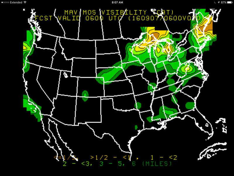
Could you elaborate on the MOS forecast images a bit.
Sure thing. "MOS" stands for Model Output Statistics and is a magic numerical technique used to slice and dice weather model output and produce graphical guidance. On the bottom of your Foreflight screen, tap on "Imagery". Then over on the left of the screen there is a menu category reading "GFS MOS" and two subcategories "Ceiling Forecast" and "Visibility Forecast". Tapping Visibility Forecast, for example, will bring up thumbnails of the forecast charts for the entire US (in my case) from 6 hrs out to 84 hours out (!). The map is color-coded to represent visibilities from <1/2 mi. to 6 miles. Last year I flew across the Country and back and found both the visibility and ceiling forecasts to be excellent planning tools. They never once let me down. The only thing you have to keep in mind is that Visibility is ground visibility, and Ceiling doesn't tell you anything about the thickness of the layer. Well heck, a picture is worth a thousand words. I just picked this one at random:

0G2HWM.png
 
All in all, it's hard to be disappointed with this update since it didn't cost any extra, but it's pretty hard for me to be excited about it either.

Its an extra cost to us. We have the Pro plan at $150 a year,and the new maps are not included. The Pro plan is no longer available and now you have to buy the Pro Plus plan at $200 a year or stay on Pro plan and not get the maps. There is new Basic Plus plan (basic plan discontinued) at 99 a year that includes new maps but it doesnt lacks some features we use.
 
Its an extra cost to us. We have the Pro plan at $150 a year,and the new maps are not included. The Pro plan is no longer available and now you have to buy the Pro Plus plan at $200 a year or stay on Pro plan and not get the maps. There is new Basic Plus plan (basic plan discontinued) at 99 a year that includes new maps but it doesnt lacks some features we use.

I was able to maintain my $79 basic subscription when I renewed a week ago. I am sure the new maps are nice, but I find the sectionals to be adequate for my needs.

Larry
 
I was able to maintain my $79 basic subscription when I renewed a week ago. I am sure the new maps are nice, but I find the sectionals to be adequate for my needs.

Larry

Would love to get Foreflight however the $US 200 ($CAN one million) is too much. Of course if Stratux works with it I might be persuaded. I read that there were difficulties with Ver 7. and Stratux

Currently using FltplanGo, I find from time to time allthough the Startux is connected to the App and it is reading numerous aircraft, they are not painted on the Map.
 
Last edited:
Would love to get Foreflight however the $US 200 ($CAN one million) is too much. Of course if Stratux works with it I might be persuaded. I read that there were difficulties with Ver 7. and Stratux

Currently using FltplanGo, I find from time to time allthough the Startux is connected to the App and it is reading numerous aircraft, they are not painted on the Map.

I have no issues using FF 7 or 8 with Stratux

Chris
 
I was able to maintain my $79 basic subscription when I renewed a week ago. I am sure the new maps are nice, but I find the sectionals to be adequate for my needs.

Larry

I too use that for VFR, and the only extra feature I would like are the ground referenced Taxiway PDF charts.

Unfortunately it seems you have to buy the full IFR package to get that feature...:(
 
I know that arguing Foreflight vs Garmin Pilot vs WingX is like arguing which EFIS is best. And they all are good. But if you're unhappy now, take a look at WingX. Among other things, WingX will run on a less expensive iPad (less memory needed). Most recent software update seems to have made the lettering sharper, easier to read.
Disclaimer: As a cfi WingX is free to me. But I chose to use it even when I had to pay for it!
 
I have the old basic plan. And I see no reason to upgrade. I am now looking at Wing X pro for the future.
 
Back
Top