What's new
Van's Air Force

Don't miss anything! Register now for full access to the definitive RV support community.

Bad weather decisions....good flight choices

Ron Lee

Well Known Member
Two days ago I decided to make a try at going to the west coast (California). Initial stops were at Catalina Island since that is a small overwater flight compared to the Bahamas, Redwood NP (National Park), Yosemite NP and Sequoia NP. Then I checked something and saw that hotel rates were about one-half of weekend rates in Las Vegas so I cut out Redwood NP and planned on making my first stop at Las Vegas to spend the night.

I am not a huge Las Vegas fan but a great deal at Luxor, the multi-color M&Ms at M&M World and the Bellagio fountains would be a change of pace.

Yesterday morning I checked the ADDS satellite map of the western USA with flight conditions and it was not good. Mountain obscuration in Colorado, Southern Utah and northern NM and AZ are iffy for this weather wuss. Some TAFs look better so I decided to wait and see if the sun would improve conditions. Off to Jills for breakfast.

When I returned home I saw a better satellite map that suggested a viable path south towards Albuquerque, southwest towards St Johns AZ then west and north to Las Vegas.

I decide to head south and hope that it clears in the northern NM/AZ area. Take-off at 1045 AM. As I am heading south I can see reasonably well to the west but there is no guarantee that just beyond where I can see it becomes an opportunity to hit a mountain or accumulate ice so I keep heading south. This is looking basically west and you can see what may be low clouds in the far distance...or maybe not.
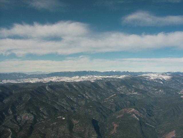
AEGStartSmall.jpg


Stop at Double Eagle NM (AEG) near Albuquerque for fuel and an update of satellite imagery and a FSS briefing. VFR not recommended for the direct flight so I elect to continue the trip south AROUND the weather.

When I get in the plane and input the direct AEG to VGT path in the GPS I made a quick mental calculation that adding in the trip towards St Johns would not leave adequate time to complete the trip in daylight so I bail and returned to Meadow Lake.

Another shot coming home. I believe that this is northern NM east of the Rockies near Las Vegas NM:
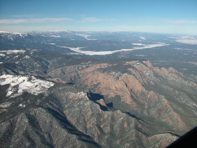
AEGEndSmall.jpg


In retrospect here is where I made the mistake that cancelled this trip. The ADDS surface chart did show a low in the area and some orange lines that may be troughs. I should have assumed that no improvement was likely. Once I found out that a viable route was around the system I should have left about two to 2.5 hours earlier than I did. That would have allowed time to get to VGT before sunset.

So I made a mistake in assessing the weather and not quickly making a change in my flight path to work around the weather but I did make safe flight choices overall by not succumbing to "get there-itis" or worrying about losing my hotel room cost.

I did call Luxor when I got home and was able to have the reservation charge refunded because I was prevented from getting there by personal plane (weather).

One difference between this flight and the one to the Bahamas. On the Bahamas trip I was more geared for warm weather to include having snorkeling gear and a wetsuit. On this trip I had a bag with winter gear (snow boots, hats, gloves, ski pants, etc) plus firestarting material, space blanket, sleeping bag.
 
Last edited:
Well done

Good job, Ron.

A successful career as a pilot requires filling that log book up one carefully executed flight at a time. A old, experienced, and still alive pilot buddy of mine summed it up once by saying "Bill, you never really HAVE to go anywhere in an airplane." Hmmm....
 
Graci Bill

That quote is exactly right but I can understand how people succumb to get there/home-itis. It is tempting. I know I am not the best pilot around. My saving grace is that I make up for shortcomings with usually good judgement. Except for not deciding to go the long route earlier of course.

I have used FSS more in that last few months than ever before and I have been very happy with them.

I am visually oriented so weather charts with flight conditions like on ADDS are very useful to me more than just numbers (METARS/TAFS) from FSS.

I am going to have to check out weathermeister.com again since my recollection is that it provides everything needed to make good decisions about a trip like this.

I just signed up for weathermeister and am glad I did. This will simplify the weather info element. The Flight conditions chart in some ways is better than ADDS since it seems to have far more sites. My initial opinion is that I would like to see a satellite picture superimposed upon his flight conditions map. But I have to use it more before suggesting that as an option.
 
Last edited:
Sounds like you made some sound choices and wise decisions to me.

In retrospect I wouldn't say you made any mistakes. Weather is really unpredictable no matter how recent the forecast. Don't think I could have done any better and maybe even worse.
 
weathermeister is a great product for flight planning. If you are doing any crosscountry at all it is a must have. I am a VFR pilot and makes the go nogo discisions alot easier.
 
Excellent!

Excellent tool use and decision-making Ron - you're going to have a lot of fun and get a lot of use out of your RV. Since you seem to be in a traveling mood, and willing to "go take a look" with a firm conviction to turning around if you don't like what you see, you might want to seriously look into XM weather - it has changed the way I fly, and gives you real-time information to make your decisions, rather than having to rely on a mental image generated from Flightwatch descriptions - or older data that you saw on the ground.

Weatehr is always changing while we are enroute, and the range and speed of the RV's make real-time weatehr information a very valuable commodity.

If you're going to take a trip a month, the fee is worth it in my opinion - you can never have too much information!

Paul
 
Get-There-Itis Fears?

Get-there-itis is not a bad thing if you are trying to get somewhere. Every cross country flight is a challenge and you have a flexible "big picture" approach to meeting the challenge. I'm sure that XM weather is excellent and I would certainly value it in my cockpit but it is not an option for me. It's my opinion that big weather systems do not change so fast that you cannot see the major potential problems that will affect your flight before you takeoff. This should fore arm you with an alternate strategy. The area where you operating is especially tough because of the high ground level mountains and restricted areas. When you are flying VFR you should be able to avoid weather confrontations by deviating to a less threatening route always keeping in mind that that too can be shut down and developing a new deviation plan real time based on your fore knowledge of the big weather picture obtained before flight, the lay of the land & airport locations, Flight Watch updates, in route monitoring (ATIS, AWOS, ASOS, etc.) and tactically what you see outside the cockpit. If you have a spare GPS like the old handheld GPS90 I have mounted between the seats it can be helpful to select your ultimate destination on it to keep track of the exact direction to it while you deviate as required to avoid bad weather (fly to the light and lowering terrain). I my flying I have never misjudged the weather so greatly that I found it necessary to return to my takeoff airport after I have committed to a trip (which can be a bigger challenge than just finding a place to land) but if the weather is threatening I don't start the trip.

You need to feel right about the flight you are conducting and having met you at Memphis and reading your posts I know you are a pilot who is in control of what he is doing, but still, there is a lot to this low altitude flying travel. If you continue flying to distant locations with the same intensity you are now, the same flight conducted by you a year from now may be flown differently. Actually, that comes across in your writing.

Bob Axsom
 
snipped:

I'm sure that XM weather is excellent and I would certainly value it in my cockpit but it is not an option for me. It's my opinion that big weather systems do not change so fast that you cannot see the major potential problems that will affect your flight before you takeoff.

Well...... out here in the mountain west, the weather situations certainly change and can do it fast. If an area of 500 miles across is effected by a large storm system, that's one thing, but new technology such as XM weather allows you to pick and choose alternate & safe mountain passes /valleys that you just can't see in while flight. In a few hours time (or less), these weather systems can simply move eastward, or swirl around and backtrack. And of course, the alternative is to sit on the ground, while conditions just 50 to a hundred miles in another direction are great! I know this, because some of my favorite flights have been in the winter months such as late November, with less than blue skies.

With all the "mountain wacking" that continues to go on out here, I'm a true advocate for technology such as XM weather, terrain mapping, and especially the 3D synthetic mesh overlays that will be the future.

L.Adamson -- Utah
 
If I can't see out there I don't fly

To each his own but I have flown through that area (everywhere from Yellowstone to El Paso) a lot in the last 25 years or so and in an RV-6A in that country I don't takeoff if I can't see where I'm flying with my eyes.

Bob Axsom
 
RE:Destroying Perfectly Good Airplanes

Ron

Great Pix and info.

I have always wondered why good intentioned folks choose to destroy perfectly good airplanes. My heart and prayers go out to them and their families.....but......why not take the position, "weather doesn't really care how many hour I have flown, how good a pilot I am, how many times I have cheated fate, and last but not least how many times scud running has allowed me to get where I REALLY needed to be??????

Check out this story from this past week!

http://www.ksl.com/index.php?nid=148&sid=2316743

Frank @ SGU RV7A.......ndy......but close.........
 
Last edited:
Good article Frank

That may have been the same system that caused problems for me Thursday. Get there-itis probably killed three more people.

My goal is that Rv pilots NEVER succumb to this problem. It is 100% preventable as is running out of fuel.

If we as a community become man enough to accept flight limitations then less people will die, kids will have fathers as they grow up, more RVs will be available to buy, and my insurance rates may decrease.

A true win-win situation.
 
Ron

Check out this story from this past week!

http://www.ksl.com/index.php?nid=148&sid=2316743

Four years ago an instructor & IFR student hit a mountain ridge very close to this one. Night conditions and no moon light. They didn't see the upcoming mountain at all.

It came down to not reviewing the sectional & using a crusing altitude that was too low. They were using a GPS for a direct course before opening an IFR flight plan while airborne, but not the newer varity with large moving map & terrain avoidance. Luckily, both survived, as the plane hit trees on a ridge line, combined with snow................and cell phones worked!

What is interesting, is that both of these flights had flight instructors on board. Obviously, someone wasn't doing their homework for flights that were less than perfect VFR daylight conditions.

But regarding the "accident" where the two survived; we flew this same flight in good VFR conditions with a RV9A and Garmin 296, and the altitude set at the same as theirs. The Garmin gave plenty of warning, as expected! I'm sure it would have done the same for the three that perished last week!

Bottom line............

Whether it's these two accidents, Scott Crossfield (weather), the American Airlines 757 in Columbia, the Hendricks Motorsports mountain crash, and a long list of others including high and low time pilots....

"New technology" can make a whopping difference when it comes to saving lives as well as aircraft, even when the pilots initally "screw up"; including those occasions, such as taking off on the "wrong" & shorter runway...

edit: Pic of (two) accident area. Wide valleys used for VFR flights are on both sides of this range.

http://img228.imageshack.us/img228/7479/dsc03227reducedop6.jpg


L.Adamson
 
Last edited:
Scudrunning

Here is the thing: If you scud run, do it right! Go slow, and be prepared to land on a road or field if the conditions warrant. Don't fly where you can't see! I liked Van's article, "Confessions of a Scud Runner"

Ron

Great Pix and info.

I have always wondered why good intentioned folks choose to destroy perfectly good airplanes. My heart and prayers go out to them and their families.....but......why not take the position, "weather doesn't really care how many hour I have flown, how good a pilot I am, how many times I have cheated fate, and last but not least how many times scud running has allowed me to get where I REALLY needed to be??????

Check out this story from this past week!

http://www.ksl.com/index.php?nid=148&sid=2316743

Frank @ SGU RV7A.......ndy......but close.........
 
Last edited:
"New technology" can make a whopping difference when it comes to saving lives as well as aircraft, even when the pilots initally "screw up"; including those occasions, such as taking off on the "wrong" & shorter runway...

New technology can also lead a person to taking risks that they otherwise might not take, ala all the Cirrus crashes in bad weather because that fancy Garmin glass panel made them feel bulletproof.

Be on your guard, folks.
 
New technology can also lead a person to taking risks that they otherwise might not take, ala all the Cirrus crashes in bad weather because that fancy Garmin glass panel made them feel bulletproof.

Be on your guard, folks.

So, given the choice between "fancy" glass....or not; what would you rather see in the cockpit, as a " riding along passenger" in example's such as this? And note, there are many accidents such as the one listed here...

NTSB Identification: LAX05FA015.
The docket is stored in the Docket Management System (DMS). Please contact Records Management Division
14 CFR Part 91: General Aviation
Accident occurred Sunday, October 24, 2004 in San Diego, CA
Probable Cause Approval Date: 5/26/2006
Aircraft: Learjet 35A, registration: N30DK
Injuries: 5 Fatal.
The Safety Board adopted the final report of this accident investigation, including the analysis and probable cause, on May 23, 2006. The Board's full report is available on : http://www.ntsb.gov/publictn/2006/AAB0605.pdf

On October 24, 2004, about 0025 Pacific daylight time, a Learjet 35A twin-turbofan airplane, N30DK, registered to and operated by Med Flight Air Ambulance, Inc. (MFAA), collided into mountainous terrain shortly after takeoff from Brown Field Municipal Airport (SDM), near San Diego, California. The captain, the copilot, and the three medical crewmembers received fatal injuries, and the airplane was destroyed. The repositioning flight was operated under the provisions of 14 Code of Federal Regulations (CFR) Part 91 with an instrument flight rules (IFR) flight plan filed. Night visual meteorological conditions prevailed. The flight, which was the fourth and final leg of a trip that originated the previous day, departed SDM at 0023.

The National Transportation Safety Board determines the probable cause(s) of this accident as follows:

The failure of the flight crew to maintain terrain clearance during a VFR departure, which resulted in controlled flight into terrain, and the air traffic controller's issuance of a clearance that transferred the responsibility for terrain clearance from the flight crew to the controller, failure to provide terrain clearance instructions to the flight crew, and failure to advise the flight crew of the MSAW alerts. Contributing to the accident was the pilots' fatigue, which likely contributed to their degraded decision-making.


It's very true that glass & especially older GPS's that just dipicted a straight line ,without a "big picture" moving map, have led to accidents.

However, are we better off sticking to the old way, and the added possibilities of additional "flight into terrain" accidents; or do we embrace new technology and avoid using words such as "fancy" and "toys" (use of these words, bug's me) when it comes this new fangled life saving equipment?

I've had this thing about "flight into terrain", ever since a DC-8 plowed into a mountain close to home. I guess it's now a personal agenda to keep up with electronics, and everything else that can help prevent this in the future. And, of course, I had to have the very first moving map aviation GPS's that Garmin made, in the early ninties. Have a whole collection, now.

L.Adamson
 
Last edited:
So, given the choice between "fancy" glass....or not; what would you rather see in the cockpit, as a " riding along passenger" in example's such as this?

What would I rather see in the cockpit as a 'riding along passenger'? I'd rather see an alert, competent, well trained pilot with good judgment in the left seat. High technology in the cockpit means little to me if the driver is not on the ball and paying attention to all the factors required to conduct a safe flight.

Sorry if I stepped on your toes with the use of the word 'fancy'. But to me a lot of this stuff is 'new fangled' and 'fancy', and doesn't mean it has no useful purpose or is unnecessarily 'glitzy'. Just trying to make the point that we shouldn't place too much reliance on it at the expense of what's between our ears.

Notice I didn't use the word 'toys'. That's because I believe they are tools, and some of them are pretty darn fancy tools. But a tool of any sort can be abused when poor judgment is applied to it's use.
 
Last edited:
Sorry if I stepped on your toes with the use of the word 'fancy'. But to me a lot of this stuff is 'new fangled' and 'fancy', and doesn't mean it has no useful purpose or is unnecessarily 'glitzy'. .

And my apology, as I sometimes get a bit bent too easily...

Afterall, you didn't use the word toy. :)

L.Adamson
 
Back
Top