
Van's Air Force
You are using an out of date browser. It may not display this or other websites correctly.
You should upgrade or use an alternative browser.
You should upgrade or use an alternative browser.
New (March 1, 2016) Garmin aera 660 Portable GPS
- Thread starter g3xpert
- Start date

One thing I have found is that if I plug it into the wall charger, it turns on. If I turn it off after it powers up, the screen stays black and there's no indication that any charging is occurring. I'm still not sure if it charges in this state or not.
I sort of wondered this too. I noticed the same thing.
Where's our tech????

Shawn25854
Well Known Member
If I remember when I turned my off here at home it faintly said "charging" or something like that on the screen.
Update......
I did the update last night and put it on the wall charger. It powered on as soon as I plugged it in so I turned it off, screen is black. Took it off the charger this evening, wouldn't power up, r&R battery, came on. But, it was one bar LESS on the battery condition than when I put it on the charger last night.
So......looks like I'm back to square one.
Is there a way to turn off the background? I mean the green/yellow shading.
I can do it by selecting the decluter. But I have to do that every time. and when it auto zooms in the back ground comes back.
I really don't see the point of the green/yellow. For me it just detracts from the clarity.
Hello Tomww,
It seems you are referring to Topo Shading. From the map page select Menu and deselect Topo Shading.
See page 23 of the Rev. B manual.
Thanks,
Steve
Another thing I noticed was, the battery indicator never did show "fully charged". Even after being on the charger for 24 hrs. I'll check it this evening to see if that was something else with the update.
Hello RV10Man,
Page 3 of the Rev. B manual explains that a new battery will not show full charge until discharged and charged back up. The battery pack includes a battery fuel gauge IC that needs to "learn" the capacity of this battery and will adjust for the meaning of "full charge" as the battery pack ages.
Page 3 of the manual also explains how battery charging mode works when you turn the unit off after plugging in the wall charger.
We keep hoping you will contact us with regard to the issue you keep reporting with needing to remove and re-install the battery pack. Please email [email protected] so we can work this issue with you.
It seems possible that you have a slightly bent battery contact that is barely making connection with the battery pack that re-establishes this connection each time the battery is removed and re-installed.
Thanks,
Steve
Thanks Steve. I will contact you.
Hello Tomww,
It seems you are referring to Topo Shading. From the map page select Menu and deselect Topo Shading.
See page 23 of the Rev. B manual.
Thanks,
Steve
Hi Steve
That was what I meant, sorry I wasn't very clear.
I had tried what you suggested and it didn't work, lots of times before posting on here. I just sat here for several minuets reading the manual and doing it, then reseting it, then turning it off gain. I was getting a bit fed up.
Then I took the SD card out of the slot. Now it works fine! Not only that the topo shading is far better than it was. But I will probably leave it of most of the time as we don't hve much in the way of mountains here in the UK.
Hello Tom,
Ok, that makes sense.
All Aera 660 units come with a worldwide basemap that generally gets the job done, but the Atlantic units also ship with an SD card that includes quite a bit of additional enhanced basemap detail for Europe.
Obviously too much detail for your taste, so just leave the SD card out of the unit and it will work fine.
Thanks,
Steve
Overall Garmin Portable lineage question.
Is there a chart that gives the specs of the 660/795/796 side by side?
The 660 appears to be recently available and may contain newer processor/speed over the older 795/796? Are newer 795/796 models coming soon? Any time horizon we may consider for this?
Is there a chart that gives the specs of the 660/795/796 side by side?
The 660 appears to be recently available and may contain newer processor/speed over the older 795/796? Are newer 795/796 models coming soon? Any time horizon we may consider for this?
Hello Tom,
Ok, that makes sense.
All Aera 660 units come with a worldwide basemap that generally gets the job done, but the Atlantic units also ship with an SD card that includes quite a bit of additional enhanced basemap detail for Europe.
Obviously too much detail for your taste, so just leave the SD card out of the unit and it will work fine.
Thanks,
Steve
I didn't know about the enhanced database. Thanks for the info. I do prefer the display without the enhancement.
But my problem with the TOPO shading remains to a certain extent. If I turn it on it will not turn off. I had to reinsert the SD card and remove it. When I removed it the TOPO turned off. I will leave the TOPO turned off, but I am a bit uncomfortable that there may be a problem. Is this something that could be a problem with my particular GPS? Maybe your bug fixing team should be told if it is unlikely to be restricted to my GPS.
Thanks
Tom
I saw a "charging" screen once as well... When I first got mine, and was doing the initial "full charge", I had powered it on and off a couple of times while playing with it, and then plugged it in to leave it overnight and this "charging" graphic came up on an otherwise black screen. I hadn't seen it before, and I have yet to see it again.If I remember when I turned my off here at home it faintly said "charging" or something like that on the screen.
I'll go read page 3 in the manual as suggested and see if it sheds any light.
Overall Garmin Portable lineage question.
Is there a chart that gives the specs of the 660/795/796 side by side?
The 660 appears to be recently available and may contain newer processor/speed over the older 795/796? Are newer 795/796 models coming soon? Any time horizon we may consider for this?
Hello,
We don't have a chart for side by side comparison, but the product pages for the Aera 796 and Aera 660 provide spec pages and you can go to the manuals page and download those for more information.
It is true that newer products incorporate newer technology that is usually faster and more capable, and the Aera 660 is no exception. The Aera 660 incorporates some nice new features like WiFi download of databases and software, but the 795/796 units also perform nicely even when doing things like panning/zooming on the IFR/VFR charts. So, it mostly comes down to whether you want a 5" or 7" display.
It is somewhat of a big deal to announce when a new product is about to be launched or even in development, so don't expect Garmin to leak out their product development activities on a public forum too often - even one as great as this!
Thanks,
Steve
I didn't know about the enhanced database. Thanks for the info. I do prefer the display without the enhancement.
But my problem with the TOPO shading remains to a certain extent. If I turn it on it will not turn off. I had to reinsert the SD card and remove it. When I removed it the TOPO turned off. I will leave the TOPO turned off, but I am a bit uncomfortable that there may be a problem. Is this something that could be a problem with my particular GPS? Maybe your bug fixing team should be told if it is unlikely to be restricted to my GPS.
Thanks
Tom
Hello Tom,
It would probably be better to contact us directly if this doesn't help.
We are quite certain that the Map, Menu, Topo Shading control works perfectly, but perhaps its operation is being complicated by the insertion/removal of that European VFR Basemap Enhancements SD card since that dramatically changes what is shown underneath the aviation navigation data.
We recommend you power-off the Aera 660, remove that SD card, and never re-insert it again.
Power on the Aera 660 without this card and verify that Topo Shading is turned off (if that is what you prefer).
Reading your posting I thought of something else. Perhaps you not only don't like Topo Shading on your map but also don't like Metro Area shading. If not, from the map page select Menu, Setup, Misc and turn off Metro Area shading.
Thanks,
Steve
"....but the Atlantic units also ship with an SD card that includes quite a bit of additional enhanced basemap detail for Europe."
So is the enhanced basemap available for download? (if I buy a 660 and fly in the US first and then return to Europe with it?)
Hello Control,
Yes, everyone who adds an Aera 660 to their FlyGarmin account will see a database category called "Map Enhancements".
Currently the only choice in the "Map Enhancements" category is this Europe enhanced basemap data with coverage for Albania, Austria, Belgium, Bosnia and Herzegovina, Bulgaria, Croatia, Cyprus, Czech Republic, Denmark, Estonia, Finland, France, Germany, Hungary, Iceland, Ireland, Italy, Kosovo, Latvia, Lithuania, Macedonia, Malta, Montenegro, Netherlands, Norway, Poland, Portugal, Romania, Serbia, Slovak Republic, Slovenia, Spain, Sweden, Switzerland, Turkey, and the United Kingdom for $39.99.
We obviously don't use this over here in the U.S., but Garmin's European pilot's like using these enhancements a lot and pushed to include this SD card containing this database for the Atlantic version - and we did. The list price of the Atlantic version (P/N 010-01518-01) is no higher than the Americas, so this is a bit of a bonus for European pilots.
If you buy a version other than Atlantic, you would need to buy both an SD card and pay for the download if you want this database, so it may not make sense for you to purchase an American version for use in Europe.
Thanks,
Steve
Hello,
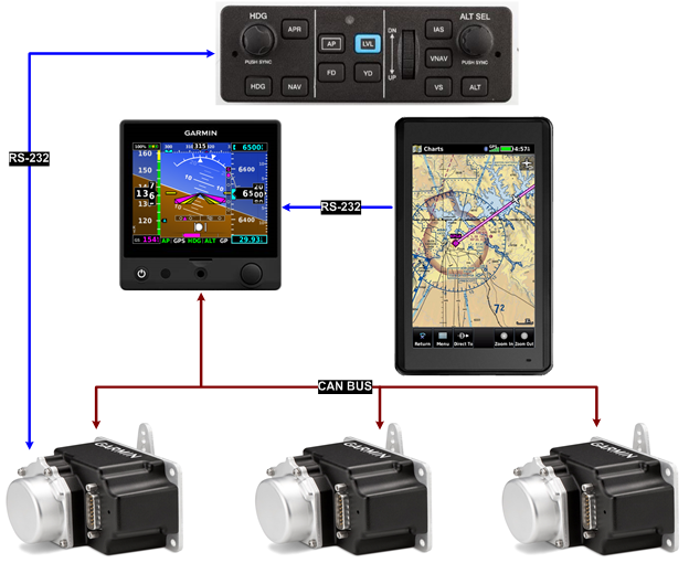
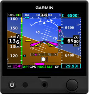
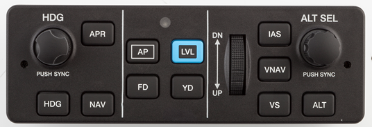
In case you didn't see this in the G5 Electronic Flight Instrument thread, we just wanted to mention that the aera 660 makes an excellent navigator for a small system with a G5, GMC 307 autopilot control panel, and servos. You can even fly coupled VNAV descents to pattern altitude with the aera 660 connected to the G5.
Thanks,
Steve
Steve,
My RV-8 is currently equipped with the following:
1. Garmin GNS 430W
2. Garmin GTX 345
3. Garmin Aera 660
4. TruTrak DigiTrak II
5. AFS 4500
I want to add the following to gain additional functionality, specifically:
1. Garmin GM 307 Autopilot Controller (replace TruTrak)
2. Garmin GSA 28 (X2) Autopilot servos
3. Garmin G5 Flight Instrument (Backup to AS 4500)(Replace ASI, VSI, ALT)
4. Garmin GAD 29 Nav Date Adaptor
Will the above proposed combination of items enable the use of the autopilot for GPS steering, WAAS LPV vertical approach guidance?
If the Garmin GNS 430W was being used for an IFR approach and the APR button on the GMC 307 autopilot control panel was activated, will the the autopilot fly the approach and will the Area 660 show the aircraft's position on the approach plate?
With a flight plan entered into 430W and the 307 was being used, what happens if the 430W goes off-line? Does the 660 become the navigator and drive the G5 and in turn the 307? Is it automatic?
When time permits, and if appropriate, could you please provide a flow chart (like the one you did above) illustrating the connectivity and flow with the GAD 29, GNS 430 and GTX 345 added to what you already have illustrated?
It would help me better understand.
Happy New Year!
Thank you,
Last edited:
Hello Tom,
It would probably be better to contact us directly if this doesn't help.
We are quite certain that the Map, Menu, Topo Shading control works perfectly, but perhaps its operation is being complicated by the insertion/removal of that European VFR Basemap Enhancements SD card since that dramatically changes what is shown underneath the aviation navigation data.
Glad to hear you are "quite certain" it works perfectly.
Unfortunately mine will not turn off the TOPO shading with the enhanced map. Maybe you confidence is misplaced?We recommend you power-off the Aera 660, remove that SD card, and never re-insert it again.
Power on the Aera 660 without this card and verify that Topo Shading is turned off (if that is what you prefer).
Reading your posting I thought of something else. Perhaps you not only don't like Topo Shading on your map but also don't like Metro Area shading. If not, from the map page select Menu, Setup, Misc and turn off Metro Area shading.
Thanks,
Steve
Removing the SD card has enabled me to turn off the TOPO shading. I find it better with the TOPO turned off as I find it easier to read the map.
Last edited:
Hello Charlie,
Thanks for your interest in these products.
Yes, the APR button on the GMC 307 tells the G5 autopilot flight director that you wish to couple to the GPS approach guidance being provided by the 430W. When flying an LPV approach (is there anything else?), pushing the APR button also arms the vertical mode to automatically capture the glidepath (GP) on the LPV approach. You can push your last button (the APR button) many miles outside the IAF on an LPV approach.
Yes, you can use the Aera 660 to display the approach plate which will also show the aircraft position on the approach.

No, there is no automatic fail-over to use the Aera 660 should the 430W fail. The G5 has a single serial interface to receive navigation guidance, and this can be configured for MapMX when interfaced to the 430W or NMEA when interfaced to the Aera 660.
As you probably know, the Aera 660 can be installed/configured to automatically receive the current flight plan from the 430W, so it makes a great backup navigator should the 430W fail. It would be possible to install a switch that you would only use to switch to using the Aera 660 as your navigator (coupled to the autopilot) should the 430W fail, but you would have to manually change the G5 RS-232 input from MapMX to NMEA to allow the G5 autopilot to follow the Aera 660, so this wouldn't be something you would want to use except as a "get home" backup. If you did, you would certainly fly home with a smile on your face with the autopilot coupled to the Aera 660 both laterally and vertically (with a flight director).
Thanks,
Steve
Thanks for your interest in these products.
Steve,
My RV-8 is currently equipped with the following:
1. Garmin GNS 430W
2. Garmin GTX 345
3. Garmin Aera 660
4. TruTrak DigiTrak II
5. AFS 4500
Yes, the G5 based autopilot will follow the guidance from the 430W and allow you to fly autopilot coupled LPV approaches with both lateral and vertical coupling (with a flight director).I want to add the following to gain additional functionality, specifically:
1. Garmin GM 307 Autopilot Controller (replace TruTrak)
2. Garmin GSA 28 (X2) Autopilot servos
3. Garmin G5 Flight Instrument (Backup to AS 4500)(Replace ASI, VSI, ALT)
4. Garmin GAD 29 Nav Date Adaptor
Will the above proposed combination of items enable the use of the autopilot for GPS steering, WAAS LPV vertical approach guidance?
If the Garmin GNS 430W was being used for an IFR approach and the APR button on the GMC 307 autopilot control panel was activated, will the the autopilot fly the approach and will the Area 660 show the aircraft's position on the approach plate?
Yes, the APR button on the GMC 307 tells the G5 autopilot flight director that you wish to couple to the GPS approach guidance being provided by the 430W. When flying an LPV approach (is there anything else?), pushing the APR button also arms the vertical mode to automatically capture the glidepath (GP) on the LPV approach. You can push your last button (the APR button) many miles outside the IAF on an LPV approach.
Yes, you can use the Aera 660 to display the approach plate which will also show the aircraft position on the approach.
With a flight plan entered into 430W and the 307 was being used, what happens if the 430W goes off-line? Does the 660 become the navigator and drive the G5 and in turn the 307? Is it automatic?
No, there is no automatic fail-over to use the Aera 660 should the 430W fail. The G5 has a single serial interface to receive navigation guidance, and this can be configured for MapMX when interfaced to the 430W or NMEA when interfaced to the Aera 660.
As you probably know, the Aera 660 can be installed/configured to automatically receive the current flight plan from the 430W, so it makes a great backup navigator should the 430W fail. It would be possible to install a switch that you would only use to switch to using the Aera 660 as your navigator (coupled to the autopilot) should the 430W fail, but you would have to manually change the G5 RS-232 input from MapMX to NMEA to allow the G5 autopilot to follow the Aera 660, so this wouldn't be something you would want to use except as a "get home" backup. If you did, you would certainly fly home with a smile on your face with the autopilot coupled to the Aera 660 both laterally and vertically (with a flight director).
Good idea!When time permits, and if appropriate, could you please provide a flow chart (like the one you did above) illustrating the connectivity and flow with the GAD 29, GNS 430 and GTX 345 added to what you already have illustrated?
It would help me better understand.
Thanks,
Steve
Steve,
Thank you for the quick and complete response.
I re-read every post in the "Garmin? Team X introduces the G5 electronic flight instrument" thread and found much to support your response to my questions and reinforce my very limited understanding of this stuff.
The posts I found most helpful over there were #77, 96 and 171. I'm listing them here as a reference for myself to go back to.
Thank you!
Charlie
BCP Boys
Well Known Member
If you did, you would certainly fly home with a smile on your face with the autopilot coupled to the Aera 660 both laterally and vertically (with a flight director).
Steve, Quick question on this. If you do lose the 430W in flight (or 650/750) how would the 660 provide vertical "guidance"? I know the 660 can provide Lateral guidance to the G5 which would steer the Autopilot, but I was not aware that the 660 would be able to provide vertical guidance if a primary IFR GPS fails. My understanding was that the only vertical information that a 660 could use to input in to an autopilot would be information similar to the VNAV profile but not as a back up to 430 on an LPV approach. That would be awesome if I am wrong
Steve, Quick question on this. If you do lose the 430W in flight (or 650/750) how would the 660 provide vertical "guidance"? I know the 660 can provide Lateral guidance to the G5 which would steer the Autopilot, but I was not aware that the 660 would be able to provide vertical guidance if a primary IFR GPS fails. My understanding was that the only vertical information that a 660 could use to input in to an autopilot would be information similar to the VNAV profile but not as a back up to 430 on an LPV approach. That would be awesome if I am wrong
Hello Amir,
The VNAV guidance provided by the Aera 660 is covered pretty well in this recent posting:
http://www.vansairforce.com/community/showpost.php?p=1138572&postcount=10
The Aera 660 is not an IFR navigator and does not provide vertical approach guidance, but makes a great backup GPS navigator.
Thanks,
Steve
I have been flying with the 660 for 6 weeks or so now. At current software level. In the MAP view at some point in about every flight I loose the terrain or map and it goes to a dark background. Depending on zoom level I might have portion of screen do this with a definite edge with terrain on one part and dark screen on the other part. If I cycle the power it will come back up with all the terrain again. Do I have some setting wrong or is this a known glitch? It is like it is not loading the maps out of memory correctly.
I have been flying with the 660 for 6 weeks or so now. At current software level. In the MAP view at some point in about every flight I loose the terrain or map and it goes to a dark background. Depending on zoom level I might have portion of screen do this with a definite edge with terrain on one part and dark screen on the other part. If I cycle the power it will come back up with all the terrain again. Do I have some setting wrong or is this a known glitch? It is like it is not loading the maps out of memory correctly.
Hello c210pa18,
Thank you for purchasing an Aera 660.
We are not aware of any problems like this in the current V2.80 software, but it is always best to contact us directly via email or phone (shown below) to receive product support since we will want to work directly with you and ask you questions like software and database versions in helping to resolve the issue.
Thanks,
Steve
Steve,
I occasionally have the same symptoms as c210pa18 above. The background goes dark as if in night mode. I have version 2.8 software as well.
Curious in St. Louis,
Oly
Hello Oly,
Same response. Please contact us directly so we can see screen shots, etc.
Not that an experienced 660 driver like you would do this, but you would be surprised how often we get a question like this when a customer hasn't disabled the display of non-coverage areas for NEXRAD, sees the purple overlay on the map, and thinks something is wrong!
Thanks,
Steve
Hmmm, Steve that went over my head, having driven the 496 for many years I'm not yet up to speed on this. So maybe that is my problem? If so I need a little more guidance. I went to the manual and am not finding what you are referring to here. I did call in and got help but was told lets try updating the data bases and see if that helps. I'm sill working on that and have been now for several hours. We will see if this helps.
Thanks Gerald
Hello Gerald,
Please take a look at this previous answer and see if that helps.
http://www.vansairforce.com/community/showpost.php?p=1115955&postcount=289
Thanks,
Steve
Looks like I will have to make use of your offer to "have my back" above. My FlyGarmin username is Snowflake6, btw.I couldn't find that you had created a free FlyGarmin account and added your Aera 660 to it, but once you do there will be a "Redeem a Coupon" button on the Aera 660 page. The process is pretty self explanatory, but if you have any questions or problems with choosing the free set of databases you want, just contact us by email/phone and we will make sure it works as expected. You are never "SOL" because we have your back (and the keys to make selection changes in FlyGarmin).
When I entered my coupon code, under IFR/VFR Charts, there were only three options given (US, Brazil, and something else that wasn't Canada). So how do I get the Canadian charts? For now I chose "US" because it wouldn't let me proceed without choosing one of them, and I don't need Brazil.
I'll assume you can help.Well, you can only load one set of IFR/VFR charts at a time, so you would have to choose, for example, if you want to subscribe to the Canada charts or the U.S. charts. If you purchase the North American database bundle, FlyGarmin asks you to select whether U.S. or Canada IFR/VFR charts are in your annual database bundle.
I took a look on the GPS after selecting the US charts. If I click on "Download", it pops up a screen showing all the states, and asking which ones I want to download. I haven't tried it, but i'm guessing if i chose them all I might hit a storage space limitation?
Given that you've built in the infrastructure and capability for selecting maps a-la-carte like this, please consider making the Canadian charts available in a similar fashion, and in conjunction with the US charts. I'd like the *western* Canadian charts, and the *northwestern* US charts. BC/Alberta/WA/OR, and maybe CA, would do.
I suspect most of your Canadian customers would also like the ability to have both the Canadian maps and a couple of adjacent US states... A majority of the population in Canada lives pretty close to the 49th parallel...
CDN/US CHARTS
''I suspect most of your Canadian customers would also like the ability to have both the Canadian maps and a couple of adjacent US states... A majority of the population in Canada lives pretty close to the 49th parallel... ''
I, for one will buy them for sure
Think about it Mr. Garmin..
Bruno
''I suspect most of your Canadian customers would also like the ability to have both the Canadian maps and a couple of adjacent US states... A majority of the population in Canada lives pretty close to the 49th parallel... ''
I, for one will buy them for sure
Think about it Mr. Garmin..
Bruno
Looks like I will have to make use of your offer to "have my back" above. My FlyGarmin username is Snowflake6, btw.
When I entered my coupon code, under IFR/VFR Charts, there were only three options given (US, Brazil, and something else that wasn't Canada). So how do I get the Canadian charts? For now I chose "US" because it wouldn't let me proceed without choosing one of them, and I don't need Brazil.
I took a look on the GPS after selecting the US charts. If I click on "Download", it pops up a screen showing all the states, and asking which ones I want to download. I haven't tried it, but i'm guessing if i chose them all I might hit a storage space limitation?
Given that you've built in the infrastructure and capability for selecting maps a-la-carte like this, please consider making the Canadian charts available in a similar fashion, and in conjunction with the US charts. I'd like the *western* Canadian charts, and the *northwestern* US charts. BC/Alberta/WA/OR, and maybe CA, would do.
I suspect most of your Canadian customers would also like the ability to have both the Canadian maps and a couple of adjacent US states... A majority of the population in Canada lives pretty close to the 49th parallel...
Hello Rob,
We corrected your account to include the Canadian IFR/VFR chart database for your coupon. If you have additional product support needs, please contact us directly rather than via a web forum.
All of the U.S. IFR/VFR charts can currently be loaded to the Aera 660 without running out of room.
Good idea to allow customers to select charts a-la-carte. We already have support for 23 countries, with more on the way, and for many of these we have to pay country specific fees (not chart specific) each time a customer purchases that country database, so there isn't presently a good way to do what you ask. We will, however, keep this in mind when discussing future subscription and data delivery options.
As mentioned in a previous post, if you want to do something like fly to Oshkosh once a year, you could buy a single U.S. IFR/VFR chart cycle for $39.99, load these charts for your U.S. travel, then re-load the Canada charts included in your annual subscription when you come home. Your North American database bundle includes navigation data for both the U.S. and Canada, so nothing to worry about for the core data which includes airports/runways/frequencies.
Thanks,
Steve
Two issues with my Aera 660
Members,
I have a few small issues with my Aera 660.
1. When looking at Weather and winds aloft, the wind barbs are so tiny I can hardly read them, even when I zoom in. Is there a way to increase their size?
2. During a weekend flight, my Aera 660 screen indicated several times -lost GPS Signal. As a footnote: My Aera 660 is hardwired to my GDL39-3D. The GDL39 is connected by Bluetooth to my Garmin App on Ipad. I also have a GTN650 in the cockpit. The ONLY device to lose GPS signal was my Aera 660. The 650 and the Garmin App seemed fine.
thanks,
Jeff
Excellent! Thanks very much. For this issue, honestly, I wouldn't even want to try calling Garmin directly. I know they would get me to the same result eventually, but I would have to give them the whole back story to get there. You're already aware of it from the history on this forum, so it was more efficient to do it this way.We corrected your account to include the Canadian IFR/VFR chart database for your coupon. If you have additional product support needs, please contact us directly rather than via a web forum.
While completely a-la-carte chart selection would be the ideal goal, it would be a good start if Garmin could allow the selection of charts a-la-carte from multiple purchased databases simultaneously. I see that I now have both IFR/VFR chart databases for Canada and the US available, but if I have some US charts installed and install any Canadian charts it boots out all of the US ones.Good idea to allow customers to select charts a-la-carte. We already have support for 23 countries, with more on the way, and for many of these we have to pay country specific fees (not chart specific) each time a customer purchases that country database, so there isn't presently a good way to do what you ask. We will, however, keep this in mind when discussing future subscription and data delivery options.
It's clearly not a storage issue, so either there is a technical issue preventing the display of both US and Canadian charts simultaneously (maybe they're in different formats?) or it's an arbitrary decision because nobody has thought to sell them together... Which seems silly given how many of your other databases are offered as a "North America" bundle.
Unfortunately this wouldn't really help either... I'm likely to fly east before I go south across the border, and after OSH i'm likely to cross back and forth into Canada to continue to the east coast. Multiple border crossings on one trip means I now have to find a good internet connection every day or two and completely swap databases... And hope I won't need to divert across the border while enroute.As mentioned in a previous post, if you want to do something like fly to Oshkosh once a year, you could buy a single U.S. IFR/VFR chart cycle for $39.99, load these charts for your U.S. travel, then re-load the Canada charts included in your annual subscription when you come home.
Realistically, half of the flights I make are over US airspace. Swapping data sets every time isn't an option, so i'll have to live with using the portion of the Canadian charts that overlap with the US. That will cover most of my local flying. For everthing else, i'll carry paper charts and/or use FltPlanGo on my phone or tablet.
Aera 660 Traffic/Terrain/Obstacle Audio Alerts
I'm using the Area 660 connected via Barewire cable to a Garmin GTX 345 ADSB All-In-One transponder. I have a Garmin 430W which is the certified GPS position source for the 345. I have a PS Engineering PM1200 Intercom with no vacant audio slots available to connect the 660 alert audio for traffic/terrain/obstacles.
Recently I made an audio cable connecting the 660 via the barewire cable to the 3.5mm jack on my Quiet Technologies Halo Headset. For those unfamiliar, the Halo headset provides a female 3.5mm auxiliary audio input jack for secondary audio sources with volume control.
Now, with the 660 connected to my headset, I get clear crisp audio alerts for traffic/terrain and obstacles in my headset.
The increased situational awareness I get with the audio alerts is very beneficial and adds aspects of safety by limiting my need to look inside and spend more time looking outside.
I really like that this combo provides alerts if you're on course to bust airspace.
For me, the 660 is proving to be a very nice addition to my panel.
Question for Garmin Experts.
Is there any advantage to getting the audio alerts from the GTX345 vs the 660?
I only have the one audio slot described above so I can't do both and think that might cause a conflict anyways.
Hello Charlie,
The traffic aural alerts provided by the GTX 345 (and GTX 45R) are a little fancier than the Aera 660. Instead of just saying "Traffic" it says things like "Traffic, 10 O?Clock, same altitude, two miles".
Most of us with portables don't connect the traffic audio from the GTX 345 and instead use the traffic/terrain/obstacle alerting from the portable, but if you had an audio panel like the GMA 245 which has 4 separately adjustable alert audio inputs, you could connect the Aera 660 audio to one alert input (with traffic aural alerts disabled) and the GTX 345 traffic audio to another alert input. Even the GTR 200 radio has 2 alert audio inputs (if you are using the GTR 200 as your intercom).
Thanks,
Steve
Last edited:
Hello Charlie,
The traffic aural alerts provided by the GTX 345 (and GTX 45R) are a little fancier than the Aera 660. Instead of just saying "Traffic" it says things like "Traffic, 10 O’Clock, same altitude, two miles".
Most of us with portables don't connect the traffic audio from the GTX 345 and instead use the traffic/terrain/obstacle alerting from the portable, but if you had an audio panel like the GMA 245 which has 4 separately adjustable alert audio inputs, you could connect the Aera 660 audio to one alert input (with traffic aural alerts disabled) and the GTX 345 traffic audio to another alert input. Even the GTR 200 radio has 2 alert audio inputs.
Thanks,
Steve
Thanks for the quick response!
Glad I asked. It would be nice to get the traffic alerts from the 345 and the other alerts from the 660. The 660 lets you enable certain function while disabling others, Pretty cool.
Both the GMA 245 and GTR 200 are on my list. I'm considering doing my panel in a stepping stone approach. These two items may be a good next step considering I now only have one comm and would like to have two.
Thanks again!
RS-242 ??
I was just updating my area 660 Pilots Guide to Rev B. Page 30 of this new rev describes the CONNEXT feature using either Bluetooth or RS-242. Is the RS-242 a typo? Should this be RS-232? I was unable to find any info (google search) for the -242 electrical interface or protocols. Just curious.
I was just updating my area 660 Pilots Guide to Rev B. Page 30 of this new rev describes the CONNEXT feature using either Bluetooth or RS-242. Is the RS-242 a typo? Should this be RS-232? I was unable to find any info (google search) for the -242 electrical interface or protocols. Just curious.
FYI - I looked at Page 3 of the manual, and based on that and playing with it this is what I think i've figured out:Page 3 of the manual also explains how battery charging mode works when you turn the unit off after plugging in the wall charger.
- If you plug it in to the wall charger while the unit is turned off, the unit will turn on and boot up.
- If you wait for it to boot up, then turn it off by holding the power button, it will go completely off and enter charging mode.
- To confirm it's in charging mode, you can tap the touchscreen and see the battery symbol and charging message.
Last edited:
G3Xperts,
What's the latest news on the 660 being upgraded to have XM music and WX? This was a software upgrade that was suppose to have been done by the end of last year.....I'm patiently waiting.
Thanks,
Mark
Hello Mark,
Thank you, we appreciate your patience.
A couple of clarifications. This posting both didn't say it was a "software upgrade" and didn't say it was "to have been done by the end of last year".
We did say we hoped to have a solution available for SXM music and weather by the end of the year, but the timeline for developing significant new products and/or features isn't as predictable as all of us would like, so this is one of the reasons for the vagueness in the original posting.
We seldom pre-announce plans of this type, and schedule uncertainty is one of the reasons why.
Please note that we will not have any details on this solution until it is announced (so don't ask
).Thanks,
Steve

I was just updating my area 660 Pilots Guide to Rev B. Page 30 of this new rev describes the CONNEXT feature using either Bluetooth or RS-242. Is the RS-242 a typo? Should this be RS-232? I was unable to find any info (google search) for the -242 electrical interface or protocols. Just curious.
Hello Noel,
Yes, just a typo. As shown everywhere else, the Aera 660 has two RS-232 interfaces.
Thanks,
Steve
Soooo if y'all ever do get SXM available for the 660 will you announce it here in this thread or a new one? Looking to replace my 496 but not willing to give up the SXM stuff.
Hello N64GH,
You can bet we will announce it on VAF when a SXM weather/music solution becomes available for the Aera 660.
Thanks,
Steve
I picked up my 660 this morning, which has been turned off and sitting on my desk for a week, turned it on, and it popped up a "Battery Low" box as soon as it could. I plugged it in, updated firmware to 2.90 (I really like how easy it is to keep this unit up-to-date!) and then rebooted to see if I could find the Charging screen again.
After a number of power cycles I was able to figure out what the manual was saying. It says to put it in charging mode to connect an external power supply and hold the power button. It does not say that you need to do this *while the unit is turned on*. If you plug it in and hold the power button while it's turned off, it won't do anything interesting (other than say "READY" on the screen at some point.
If you turn the unit off while it is plugged into external power, it will go into charging mode. To confirm this, you can tap the touchscreen and you will see the battery symbol, and a battery charging message.
What i'm wondering now is how it went from a full battery to an empty battery when it's been turned off, and sitting in a heated office for a week. I hope it won't run down when it's installed in my panel, in an unheated hangar, and left for a week or two.
Last edited:
Jetguy
Well Known Member
Next software update request the font size increase by 2 points the, "Airspace Segment Altitude Limit Labeling"! Love the extra User selectable data Fields and the ability to show the current winds and altimeter for your destination in them if you have ADSB in capability. Great Job!
Update: This week it seems to be holding a charge just fine. I left it alone during the week and now this AM it still shows full charge when I turn it on. I'm still wondering how it discharged, but it seems to be okay now, anyway.
One thing I do notice is that the power button is *very* sensitive. You barely need to brush it and the unit starts turning on, which means you have to stand there and wait 30 seconds before you can turn it off again. This wasn't an issue with the older Aera 500 I had, you needed to hold the power button before anything would happen with it.
One thing I do notice is that the power button is *very* sensitive. You barely need to brush it and the unit starts turning on, which means you have to stand there and wait 30 seconds before you can turn it off again. This wasn't an issue with the older Aera 500 I had, you needed to hold the power button before anything would happen with it.
Aera 660 and Garmin VIRB Ultra 30 camera
Finally got around to getting a Garmin VIRB Ultra 30 camera mounted to replace the GO Pro. I think Garmin has broken the code with this one. Why do I have comments here in the Aera 660 you ask? Because not only is the 660 an awesome and capable GPS, is has a VIRB button in the menu to control the VIRB camera.
You are gonna love this- the best part is you can plug the camera into an onboard USB port and never have to worry about batteries again! I have mine plugged into a USB port for power, use Bluetooth from my headset to simultaneously record audio and stop and start recording with the 660 VIRB button. Don't know if the 660 shows a preview like you can get with the Garmin VIRB app on a phone but it does have Wifi so I'm going to try it and see. I can use the IPhone and Wifi with the app to see what the camera is recording though I don't know if you can do all this at once.
For those of you with a Go Pro, this was always my biggest complaint- the sh***y battery life. If I had an external audio source plugged in and tried to use Wifi (with the IPhone Go Pro app) as well, the battery would be lucky to last 20-30 minutes. And on top of that, the Wifi was very unstable and would kick off and the camera would freeze after only a couple minutes of use. If I didn't use the Wifi and pressed the record button before climbing in it would work fine but the battery never lasted more than 30-40 minutes.
Way to go Garmin- you hit this one out of the park. BTW- the video is much better than Go Pro in my opinion. Will try to get some video and post here on the forum soon.
Last edited:

