
Van's Air Force
You are using an out of date browser. It may not display this or other websites correctly.
You should upgrade or use an alternative browser.
You should upgrade or use an alternative browser.
Take Off Performance - Density Altitude
- Thread starter aerial
- Start date

az_gila
Well Known Member
Koch Chart
Items 1) and 3) would be covered by the standard FAA Koch Chart...
On page 3 of this safety document.
http://www.gofir.com/aviation_accident_prevention_program/docs/pdf/density_altitude.pdf
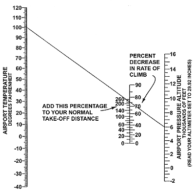
Our RVs should be pretty close to the physics of this chart...") Use Vans numbers as a baseline.
Use Vans numbers as a baseline.
Anything more exact should be done as actual testing with your specific aircraft.
gil A
Items 1) and 3) would be covered by the standard FAA Koch Chart...
On page 3 of this safety document.
http://www.gofir.com/aviation_accident_prevention_program/docs/pdf/density_altitude.pdf
Our RVs should be pretty close to the physics of this chart...
Use Vans numbers as a baseline.Anything more exact should be done as actual testing with your specific aircraft.
gil A
RVs use so many different engine and propeller combinations it would be almost impossible to get reliable data. Use of the Koch Chart should give some idea about what to expect.
I recently viewed a DVD in which a well respected and highly experienced pilot carefully tested several certified airplanes against the high altitude performance data provided in those airplane's pilot operation manuals. Not one of those certified airplanes could come within 20% of the performance data published in their POH under actual conditions.
What ever you calculate your performance to be, are you willing to bet your life and the lives of those who ride with you on your figures? Real experience in safe situations under actual conditions is the only way I know of to get a good estimate how your airplane will do. After you are in the air is a poor time to learn that you can't out climb the terrain.
Thank you, this is exactly what I was looking for. I am taking my checkride on Monday and the examiner has asked me to compute Take Off Performance at a high density altitude airport. I think he assumes I have access to a density altitude chart for my experimental.
Items 1) and 3) would be covered by the standard FAA Koch Chart...
On page 3 of this safety document.
http://www.gofir.com/aviation_accident_prevention_program/docs/pdf/density_altitude.pdf
gil A
An interesting function could be added to our EFIS.......a feature which will record the info. to build take-off data to customize our own table of take-off performance.
Our baro. pressure is entered as our normal procedure, OAT is measured and recorded so we will have density altitude.
With WAAS GPS built in or interfaced to the EFIS couldn't a distance be determined when an altitude change is detected?
A button push could tell the EFIS our starting point.
Something like this could help us gather very accurate info to develop our POH.
Glenn Wilkinson
rmartingt
Well Known Member
An interesting function could be added to our EFIS.......a feature which will record the info. to build take-off data to customize our own table of take-off performance.
Our baro. pressure is entered as our normal procedure, OAT is measured and recorded so we will have density altitude.
With WAAS GPS built in or interfaced to the EFIS couldn't a distance be determined when an altitude change is detected?
A button push could tell the EFIS our starting point.
Something like this could help us gather very accurate info to develop our POH.
Glenn Wilkinson
That information's probably already recorded, just not marked specifically for takeoff. I'd imagine if you run the engine up before releasing the brakes and look for a distinct altitude change (or the point 50ft above the runway) you would have good marking points for your takeoff run without having to have a special mark feature or takeoff function. It would require a little manual analysis of the recorded data, but it could be done already.

