jliltd
Well Known Member
Garmin Portables TFR Database Error
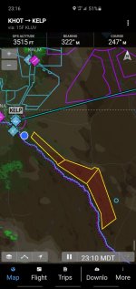
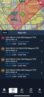
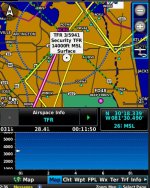
I have a question about the accuracy of Garmin's TFR descriptions as they are shown on the maps of our aera 660's and 760's. There are three contiguous TFRs along the border between the US and Mexico. 2/0045, 2/0046 and 2/0047. These are located down the Rio Grande from El Paso, Texas to Van Horn, Texas. Local pilots have run into arguments in the air because the Garmin database says these TFRs are from the surface up to FL13. However all the other "competitive" databases show these TFRs are from 10K to 13K. As does the FAA Notam web site. Not the surface up like Garmin's depictions state. So why would the Garmin database not state the proper altitudes of these TFRs? This would be very important information. The Garmin flyers are diverting around this airspace trusting their Garmin TFR information and not wanting to "virtually" violate the TFR. All the while the Foreflight, iFly, FlyQ, Avidyne flyers can just fly under it without violation per the official FAA NOTAM.
I have a question about the accuracy of Garmin's TFR descriptions as they are shown on the maps of our aera 660's and 760's. There are three contiguous TFRs along the border between the US and Mexico. 2/0045, 2/0046 and 2/0047. These are located down the Rio Grande from El Paso, Texas to Van Horn, Texas. Local pilots have run into arguments in the air because the Garmin database says these TFRs are from the surface up to FL13. However all the other "competitive" databases show these TFRs are from 10K to 13K. As does the FAA Notam web site. Not the surface up like Garmin's depictions state. So why would the Garmin database not state the proper altitudes of these TFRs? This would be very important information. The Garmin flyers are diverting around this airspace trusting their Garmin TFR information and not wanting to "virtually" violate the TFR. All the while the Foreflight, iFly, FlyQ, Avidyne flyers can just fly under it without violation per the official FAA NOTAM.
Last edited: