What's new
Van's Air Force

Don't miss anything! Register now for full access to the definitive RV support community.

AOPA Internet Flight Planner

n5lp

fugio ergo sum
InternetFP.jpg

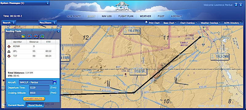
I liked the old AOPA Flight Planner application but it was a Windows product which made it a pain for me to use as I prefer Macs. I noticed a couple of weeks ago that AOPA announced the beta version of a new web based flight planner. Today I had time to look at it in some depth. I think it is a big winner.

The Internet Flight Planner is an integrated flight planning, flight plan filing, and weather briefing application. Like the old application it keeps your pilot and aircraft information stored. This application can also store your routes.

When you start the application it comes up in the "New Route" window. The other modules are available by buttons across the top of the window. In the "New Route" window you put in your route information such as departure and destination, time enroute, altitude, etc. If you don't know identifiers it can find them for you.

The next button is "Chart" which I consider the heart of the application. Your route will show on the configurable chart. The chart can show terrain or not, airways, obstructions, roads, localizers and other things. Most things can be toggled on or off. It also shows TFRs. You can drag the chart around and zoom in and out. From the chart window you can modify your route by double clicking on fixes, such as airports or intersections. It doesn't seem to work with user fixes. This route modification method isn't quite as nice as the old Windows application where you could just grab and drag the route line around. You can click on some items to get extra information. For instance you can show AOPA information on airports along the route, including gas prices, or get information on restricted areas or MOAs.

Various weather items can also be overlayed on the chart, such as winds aloft forecasts and NEXRAD radar. I believe this is the first time that I have ever seen a weather source that also has some lightning information at no extra cost, although the information seems to be quite basic.

As with the old application, you can print out your kneeboard NavLog and file a flight plan. You can also get the official DUATS briefing. Aside from the DUATS briefing there are graphical weather maps on the right side of the weather page of most things you might want. They are easily modified for altitude or animated in the case of satellite photos or radar information.

There are still a couple of things that are not implemented but I am very happy with this application that is available at no extra cost for AOPA members and that is available on pretty much any computer anywhere that can be connected to the internet.

http://www.aopa.org/aifp/welcome.cfm?
 
Someone posted a few weeks ago here about the new planner. I've been using it for "virtual trips" and I really like it. There are several differences from the previous version, and there are a few things that seem awkward, but so far, so good.
Don
 
Try a VFR trip...

...from Tucson (TUS) to Houston (SGR) at 9500 ft via Airways.

It will route you over 4000 miles around the Rockies way into Northern Canada and then South...:eek:

Not that I've got anything against the Canadians, eh (Red Deer, Alberta is on next summers travel list)...but it doesn't seem an efficient way to get from AZ to TX in winter....:)

I let the beta team know over a week ago, but no action yet.
It also won't take our airpark (57AZ) as an initial point - don't know abut other private strips...

I personally like SkyVector for very intial planning, and the free EAA version of AeroPlanner for actual flight planning - the map scanning feature in SkyVector is better and quicker than both the EAA and AOPA ones.

AirNav seems best for fuel prices, and a route links nicely from WeatherMeister.

For weather along a route, and winds aloft, then it's hard to beat Dan C's WeatherMeister (disclosure - I am a beta tester for it).

EAA AeroPlanner is here (use left side menu)

http://www.eaa.org/pilots/

www.skyvector.com

www.weathermeister.com

http://www.airnav.com/fuel/

..but everyone has their favorites... use the above links, try them all and pick...:)
 
For planning purposes, http://runwayfinder.com is a good quick tool to take a look at routing on a sectional overlay as well at conditions at local reporting stations. The nice thing is that it's a relatively fast interface.
 
MEA

...from Tucson (TUS) to Houston (SGR) at 9500 ft via Airways.

It will route you over 4000 miles around the Rockies way into Northern Canada and then South...:eek:

Not that I've got anything against the Canadians, eh (Red Deer, Alberta is on next summers travel list)...but it doesn't seem an efficient way to get from AZ to TX in winter....:)

I let the beta team know over a week ago, but no action yet.
It also won't take our airpark (57AZ) as an initial point - don't know abut other private strips...

The software is simply looking at the MEA (Minimum Enroute Altitude) as charted. The MEA in your example is 11000 feet between CIE and CUS on V16 so if you "file" for lower, you get a tour of the frozen north. I realize that some of this is due to the assumption of VOR navigation but I can't fault the system for making this call since you gave it a route based on Victor Airways. If you select "direct" then add a couple of waypoints (very easy, just click on the waypoint) it will accept 9500 as an enroute altitude.

John Clark
RV8 N18U "Sunshine"
KSBA
 
I am pretty sure the old version of the planner would do the same thing.

The software is simply looking at the MEA (Minimum Enroute Altitude) as charted. The MEA in your example is 11000 feet between CIE and CUS on V16 so if you "file" for lower, you get a tour of the frozen north. I realize that some of this is due to the assumption of VOR navigation but I can't fault the system for making this call since you gave it a route based on Victor Airways. If you select "direct" then add a couple of waypoints (very easy, just click on the waypoint) it will accept 9500 as an enroute altitude.

John Clark
RV8 N18U "Sunshine"
KSBA
 
Problem with DUAT

I checked out the new flight planner but could not use it due to the fact that it says my DUAT password is too long. I can go to the desktop realtime flight planner (AOPA) or the actual DTC DUAT website and log in just fine. Only the new web-based flight planner has a problem with my password. Anybody know what givs?
 
Back
Top