

Paul Eastham
Well Known Member
I didn't have time to take my wingtip off and run new wires before my upcoming summer trip, so I rigged up this totally-standalone tracker, using the Micro-Trak 300, a 9-volt battery and the new, tiny GPS3. All this contained in the MicroTrak shipping package, attached to the longeron in the baggage compartment with velcro, and with their lightweight antenna taped to the window.
I also mounted a power switch on the other endcap.
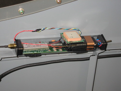
I calculate I should be able to get about 10 hours per battery, haven't reached the end of a battery yet. I'm getting pretty good tracks out of it, though there is some obvious blanking from the fuselage in certain areas.
The GPS3 is also cool because it has TTL output in addition to normal serial output, so you can use it for other projects too.
I'm headed across the Sierras tomorrow morning (~7-9AM PDT), if anyone wants to track! See my signature for the link.
Paul
I also mounted a power switch on the other endcap.
I calculate I should be able to get about 10 hours per battery, haven't reached the end of a battery yet. I'm getting pretty good tracks out of it, though there is some obvious blanking from the fuselage in certain areas.
The GPS3 is also cool because it has TTL output in addition to normal serial output, so you can use it for other projects too.
I'm headed across the Sierras tomorrow morning (~7-9AM PDT), if anyone wants to track! See my signature for the link.
Paul
")

