

All good things must come to an end, and so this morning I had to finish my Oshkosh/Minnesota visit with the flight back to the Houston area. Louise also had to head home to the D.C. area, so we looked at weather together the night before, and it sure looked like I was getting the short end of the stick! She had no predicted precip or weather at all - I had good stuff until Arkansas, and then it appeared that dodging thunderstorms was going to be the order of the day. Ah well...that's why we have all those great toys!
Launching a little before 0800 out of Anoka County (thanks again go to Alex and Pete for the use of their hangar!), I had a smooth three hours with no significant weather or turbulence all the way to Neosho, MO. The winds were showing head for the first 500 miles, increasing with altitude, so I settled in at 7500' burning 8.2 gph at 170 knots. The initial headwind did drop off down around Kansas City, but by that time, I was thinking arrival and looking ahead to the weather and terrain on the second leg.
Neosho was a nice stop with friendly folks to talk to while fueling - they are opening a brand new terminal in a few weeks, and it looks nice (although the locals figured it would increase the price of gas). I tagged up with Louise by cell phone - she had left ANE behind me, and was refueling somewhere southeast of Chicago. It is simply amazing the kind of connectivity we can have these days.
The big mass of storms that had my attention extended from Fort Smith down to Longview in Texas, and from a little east of Dallas to the Texarkana region. Drawing my course line on top of them, the shortest deviation would have been to the east, but something told me that the Louisiana area was more unstable than the Texas side, and I have a saying for summer weather - when in doubt, deviate west!. I plotted a course around the mess, and starting the deviation at Neosho (rather than going right up to it and then detouring), going all the way over almost to the DFW Class B, then heading back on course to the east side of Houston (cheap fuel at Liberty this month!), I was only adding 24 miles to the route, so I cranked it all into the flight plan and climbed to 12.5K to watch the weather unfold.
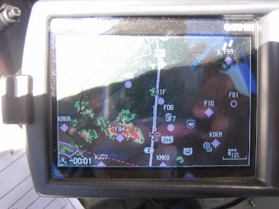
With nothing to do but check weather and watch the autopilot fly, I took a couple of pictures as a passed a cell northeast of Dallas. Here's what it looked like on the 396. Sorry for the glare - note the cell off the left wing with lightning, and the small cell without lightning of the nose.
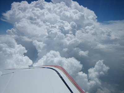
Here's what he cell to the left looked like in real life:
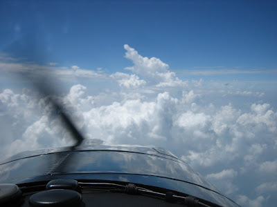
And here's what was off the nose at the same time:
After passing the cell to the left, I turned a few degrees left to avoid the one ahead, and shortly thereafter, I turned the corner on th whole mess and slid on down to Liberty. I kept looking east, and sure enough, the whole of Louisiana had popped into thundershowers, and finding a way through would have been a lot of work - down low, bumpy and hot. Glad I did it the way I did.
Total flight time for th day turned out to be almost exactly six hours, and the temperature in Houston a muggy 95 degrees. You know it's hot when you have both vents open at 12.5 and the air feels comfortable.
A day flying each way, a day at Oshkosh, a few days with the parents, and a nice day flying up to Duluth with Louise (a topic for another post....) and all possible with these dream machines called RV's. As I was wiping the bugs of the wings, the cell phone rang - Louise had made it home with her -6, so all is right with the world. Back to work again - I'm sure I have a lot to get caught up on before a shuttle launch attempt next week....
Launching a little before 0800 out of Anoka County (thanks again go to Alex and Pete for the use of their hangar!), I had a smooth three hours with no significant weather or turbulence all the way to Neosho, MO. The winds were showing head for the first 500 miles, increasing with altitude, so I settled in at 7500' burning 8.2 gph at 170 knots. The initial headwind did drop off down around Kansas City, but by that time, I was thinking arrival and looking ahead to the weather and terrain on the second leg.
Neosho was a nice stop with friendly folks to talk to while fueling - they are opening a brand new terminal in a few weeks, and it looks nice (although the locals figured it would increase the price of gas). I tagged up with Louise by cell phone - she had left ANE behind me, and was refueling somewhere southeast of Chicago. It is simply amazing the kind of connectivity we can have these days.
The big mass of storms that had my attention extended from Fort Smith down to Longview in Texas, and from a little east of Dallas to the Texarkana region. Drawing my course line on top of them, the shortest deviation would have been to the east, but something told me that the Louisiana area was more unstable than the Texas side, and I have a saying for summer weather - when in doubt, deviate west!. I plotted a course around the mess, and starting the deviation at Neosho (rather than going right up to it and then detouring), going all the way over almost to the DFW Class B, then heading back on course to the east side of Houston (cheap fuel at Liberty this month!), I was only adding 24 miles to the route, so I cranked it all into the flight plan and climbed to 12.5K to watch the weather unfold.
With nothing to do but check weather and watch the autopilot fly, I took a couple of pictures as a passed a cell northeast of Dallas. Here's what it looked like on the 396. Sorry for the glare - note the cell off the left wing with lightning, and the small cell without lightning of the nose.
Here's what he cell to the left looked like in real life:
And here's what was off the nose at the same time:
After passing the cell to the left, I turned a few degrees left to avoid the one ahead, and shortly thereafter, I turned the corner on th whole mess and slid on down to Liberty. I kept looking east, and sure enough, the whole of Louisiana had popped into thundershowers, and finding a way through would have been a lot of work - down low, bumpy and hot. Glad I did it the way I did.
Total flight time for th day turned out to be almost exactly six hours, and the temperature in Houston a muggy 95 degrees. You know it's hot when you have both vents open at 12.5 and the air feels comfortable.
A day flying each way, a day at Oshkosh, a few days with the parents, and a nice day flying up to Duluth with Louise (a topic for another post....) and all possible with these dream machines called RV's. As I was wiping the bugs of the wings, the cell phone rang - Louise had made it home with her -6, so all is right with the world. Back to work again - I'm sure I have a lot to get caught up on before a shuttle launch attempt next week....
Last edited:
 Both the XM and visual views were intimidating
